

You are here
Avalanche Advisory for 2017-02-15 06:11:32
- EXPIRED ON February 16, 2017 @ 6:11 amPublished on February 15, 2017 @ 6:11 am
- Issued by Nick Meyers - Shasta-Trinity National Forest
Bottom Line
The avalanche danger is LOW and normal caution is advised for today.
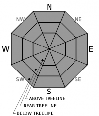
Tonight, the avalanche danger will rise with regards to new wind and storm slab problems, primarily near and above treeline. MODERATE to CONSIDERABE avalanche danger is likely to be met late tonight or tomorrow morning with high intensity wind and snowfall expected.
Instabilities will lie within new snow layers or at the old snow-new snow interface.


Avalanche Problem 1: Normal Caution
-
Character ?

-
Aspect/Elevation ?
-
Likelihood ?CertainVery LikelyLikelyPossible
 Unlikely
 -
Size ?HistoricVery LargeLargeSmall

Low danger and normal caution mean that there is a low likelihood of an avalanche occurring with the current conditions, but does not mean the backcountry is free of hazard. New wind and storm slabs will pose little to no issues today and normal caution is advised for daylight hours. Tonight, rain turning into high intensity snowfall and southerly wind will cause wind and storm slab avalanche danger to rise. Early tomorrow morning and into the AM hours will likely host the highest avalanche danger.
Forecast Discussion
Very good snowpack stability exists throughout the advisory area.. Despite this, there is never a 100% guarantee of safety in the backcountry. Basic avalanche rescue skills are essential, and backcountry travelers should always carry a beacon, shovel and probe. Watch for isolated instabilities and choose terrain appropriately. Make sure to have a plan before heading out and to exercise smart travel techniques to further reduce your risk.
Recent Observations
We have a balmy temperature of 49 degrees in Mt Shasta City this morning. Overnight lows at local weather stations are at or just above freezing. Winds were previously blowing out of the southeast yesterday until about 1800 and then switched to southwest, 10-15 mph. We do not have any new observations and conditions remain much the same as yesterday. No avalanche activity has occurred in over a week. No evidence of blowing snow and/or presence of a reactive wind slab problem has been observed. No evidence of wet loose instabilities were observed. Relatively uniform and smooth snow surfaces were found above 8400ft. One to three centimeters of moist snow rests atop a very firm and consolidated snowpack up to 9500ft. A few surfaces were glazed over by a thin ice lens. The majority of surfaces encountered were melted, but very supportable underneath, creating corn-like riding conditions.
Weather and Current Conditions
Weather Summary
An approaching front will make landfall today and has already started to produce some light precipitation to the west. Increasing clouds throughout the day with light rain will start us off. Overnight, winds and rain will ramp up with 1.27" of water expected and 6,600 foot snow levels. Today is warm with 9,700 foot levels forecasted and less than a quarter inch of water. Tomorrow, post frontal showers will bring up to a half inch of water and 5,700 foot snow levels. Winds are impressive with this storm and I would not doubt if 60+ mph winds were recorded on Gray Butte and guaranteed up at mid and upper mountain levels. This system will pass Thursday morning with the next system expected Friday into Saturday. Overall, models suggest a wet pattern of weather into next week with near or below normal temperatures.
===========================================================
In Mt Shasta City at 0500, we have a current temperature of 49 F with partly cloudy skies skies and breezy.
On Mt Shasta (South Side) in the last 24 hours...
Old Ski Bowl - 7,600ft. the current temperture is 34 degrees F. Temperatures have ranged from 34 F to 49 F. Snow on the ground totals 157 inches with no new snow and little settlement.
Grey Butte - 8,000 feet, the current temperature is 32 degrees F. Temperatures have ranged from 32 F to 47 F. Winds have averaged 10 mph with gusts to 28 mph, blowing southeast until 1700 and then switching to southwest.
Mt Eddy Range (West side of Interstate-5)...
Castle Lake - 5,800 feet, the current temperature is 36 degrees F. Temperatures have ranged from 36 F to 56 F. Snow on the ground totals 81 inches with no new snow and 3 inches of settlement.
Mt Eddy - 6,500 feet, the current temperature is 36 degrees F. Temperatures have ranged from 35 F to 52 F. Snow on the ground measures 78 inches with no new snow and 2 inches of settlement. Winds have averaged 1-2 mph with gusts to 19 mph, blowing southerly in direction.
THIS SEASON PRECIPITATION for MT SHASTA CITY: Since October 1st (the wet season), we have received 39.04 inches of water, normal is 25.67 inches, putting us at 152% of normal. For the month of February, we have received 6.78 inches of water, normal is 3.40, which is 199% of normal. And finally for the year of 2017, we received 17.88 inches of water, normal is 10.46 inches, putting us at 170% of normal.
Always check the weather before you attempt to climb Mt Shasta. Further, monitor the weather as you climb. Becoming caught on the mountain in any type of weather can compromise life and limb. Be prepared.
| 0600 temperature: | 38 |
| Max. temperature in the last 24 hours: | 50 |
| Average wind direction during the last 24 hours: | SE to SW |
| Average wind speed during the last 24 hours: | 5-10 mi/hr |
| Maximum wind gust in the last 24 hours: | 15 mi/hr |
| New snowfall in the last 24 hours: | 0 inches |
| Total snow depth: | 92 inches |
Two Day Mountain Weather Forecast
Produced in partnership with the Medford NWS
| For 7000 ft to 9000 ft | |||
|---|---|---|---|
|
Wednesday (4 a.m. to 10 p.m.) |
Wednesday Night (10 p.m. to 4 a.m.) |
Thursday (4 a.m. to 10 p.m.) |
|
| Weather | Rain showers likely before 4pm, then rain and snow showers likely. Cloudy. Breezy. Chance of precipitation is 60%. | Rain and snow likely before 10pm, then snow. The snow could be heavy at times. Windy. Chance of precipitation is 100%. | Snow before 10am, then snow showers, mainly after 10am. The snow could be heavy at times. Chance of precipitation is 100%. |
| Temperature (°F) | 41 | 30 | 34 |
| Wind (mi/hr) | South/Southeast 15-20 mph | South 25-30 mph | South/Southwest 10-15 mph |
| Precipitation SWE / Snowfall (in) | / .16" rain | / 10-15 | / 6-10 |
| For 9000 ft to 11000 ft | |||
| Wednesday | Wednesday Night | Thursday | |
| Weather | Snow showers likely, mainly between 10am and 4pm, then snow likely after 4pm. Cloudy. Windy. Chance of precipitation is 60%. | Snow. The snow could be heavy at times. Wind chill values as low as zero. Windy. Chance of precipitation is 100%. | Snow before 10am, then snow showers, mainly after 10am. The snow could be heavy at times. Wind chill values as low as -12. Windy. Chance of precipitation is 100%. |
| Temperature (°F) | 35 | 21 | 21 |
| Wind (mi/hr) | Southwest 40-45 mph | South/Southwest 0-1 | West/Southwest 30-40 mph |
| Precipitation SWE / Snowfall (in) | / 0-1 | / 12-17 | / 8-12 |

