

You are here
Avalanche Advisory for 2017-03-05 06:45:00
- EXPIRED ON March 6, 2017 @ 6:45 amPublished on March 5, 2017 @ 6:45 am
- Issued by Aaron Beverly - Mount Shasta Avalanche Center
Bottom Line
Avalanche danger near and above treeline is HIGH today due to the likelihood of natural and human-triggered wind slab avalanches. Secondary concerns are storm slabs below treeline and cornice falls at and above treeline. Avoiding avalanche terrain at all elevations and aspects is a wise approach to backcountry travel today. Avalanche terrain is a slope with an angle greater than 30 degrees. Avalanche danger below treeline is CONSIDERABLE due to isolated wind slabs and storm slabs.


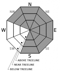
Avalanche Problem 1: Wind Slab
-
Character ?

-
Aspect/Elevation ?
-
Likelihood ?CertainVery LikelyLikelyPossible
 Unlikely
 -
Size ?HistoricVery LargeLargeSmall

Wind slabs are the primary concern in the backcountry today on leeward aspects. Winds have been blowing predominantly out of the southwest and west and will continue today and tomorrow, but some northwest winds have been measured. Observations verify that loading has occurred on southerly aspects in addition to northwest, north, northeast and east facing slopes. With 8-10 inches of snow received yesterday above Bunny Flat, and another 9-20" on the way, coupled with continued moderate to strong winds, expect windslabs to be several feet thick in places. Pay attention to the wind and stay clear of loaded areas greater than 30 degrees!
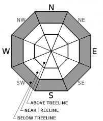
Avalanche Problem 2: Storm Slab
-
Character ?

-
Aspect/Elevation ?
-
Likelihood ?CertainVery LikelyLikelyPossible
Unlikely
-
Size ?HistoricVery LargeLargeSmall
Storm slabs may be encountered today in wind sheltered areas below treeline. Keep an eye out for consolidated snow atop a less dense layer in the new storm snow. Shooting cracks can indicate the presence of a storm slab. When in doubt, stick to slopes below 30 degrees!
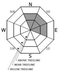
Avalanche Problem 3: Cornice
-
Character ?

-
Aspect/Elevation ?
-
Likelihood ?CertainVery LikelyLikelyPossible
Unlikely
-
Size ?HistoricVery LargeLargeSmall
With continued moderate to strong winds and plenty of new snow available for transport, expect existing cornices to grow. With added weight and increased overhangs, these cornices may break naturally or with the weight of an unsuspecting backcountry traveler. A falling cornice could easily trigger a wind slab avalanche today. When traveling along ridges make sure you are above terra firma. If unsure, steer well clear of those edges!
Forecast Discussion
4-10 inches of new snow was measured or observed within the forecast area. Another 9 to 20 inches is expected over the next 24 hours. New wind slabs will continue to grow today and tonight as winds continue to transport snow, and with the added weight, some natural avalanches are likely to be seen.
Recent Observations
A small wind slab avalanche was ski-triggered yesterday on a NW aspect of Right Peak at Castle Lake. The crown was 8-10 inches, twice the amount of the accumulated snow in the area. What better evidence that wind loading is occurring and avalanche danger is considerable? See the posted observation for more information.
Isolated wind slabs were also observed above Bunny Flat on north, east and southerly aspects.
Shallow storm slabs were seen below treeline where 2-3 inches of denser snow lay atop lighter less consolidated snow. New snow above Bunny was measured at 8-10 inches.
Weather and Current Conditions
Weather Summary
A winter weather advisory will be in effect until 4 p.m. today, with a winter storm warning in effect afterwards until Monday at 4 p.m.. With up to an inch of water still predicted through Monday afternoon, we could receive up to another foot of snow today and tomorrow. Snow levels could be as low as 500' today with a slight increase tomorrow to 1000-1500'. Windy and cold weather will prevail through tomorrow. After Tuesday, warmer temperatures and scattered rain and snow showers will prevail until the weekend.
===========================================================
In Mt Shasta City at 0500, we have a current temperature of 29 F.
On Mt Shasta (South Side) in the last 24 hours...
Sand Flat - 6750 ft, the current temperture is 20 degrees F. Temperatures have ranged from 20 F to 30 F. Snow on the ground totals 117 inches with 6 inches of new.
Old Ski Bowl - 7,600ft. This weather station is currently down. We apologize for the inconvenience.
Gray Butte - 8,000 feet, the current temperature is 14 degrees F. Temperatures have ranged from 24 F to 14 F. Winds have ranged from West to Southwest and switched to WNW averaging 23 mph with gusts to 56. Highest sustained wind was 37.
Mt Eddy Range (West side of Interstate-5)...
Castle Lake - 5,800 feet, the current temperature is 20 degrees F. Temperatures have ranged from 32 F to 15 F. Snow on the ground totals 112 with 5 inches of new..
Mt Eddy - 6,500 feet, the current temperature is 17 degrees F. Temperatures have ranged from 31 F to 17 F. Snow on the ground measures 107 inches with 4 inches of new. Winds have ranged from WSW to ESE, averaging 2 mph with gusts up to 10.
THIS SEASON PRECIPITATION for MT SHASTA CITY: Since October 1st (the wet season), we have received 43.62 inches of water, normal is 30.53 inches, putting us at 143% of normal. For the month of March, we have received .31 inches of water, normal is 1.03, which is 30 % of normal. And finally for the year of 2017, we received 22.46 inches of water, normal is 15.32 inches, putting us at 147% of normal.
Always check the weather before you attempt to climb Mt Shasta. Further, monitor the weather as you climb. Becoming caught on the mountain in any type of weather can compromise life and limb. Be prepared.
| 0600 temperature: | 17 |
| Max. temperature in the last 24 hours: | 30 |
| Average wind direction during the last 24 hours: | West Southwest |
| Average wind speed during the last 24 hours: | 23 mi/hr |
| Maximum wind gust in the last 24 hours: | 56 mi/hr |
| New snowfall in the last 24 hours: | 6 inches |
| Total snow depth: | 117 inches |
Two Day Mountain Weather Forecast
Produced in partnership with the Medford NWS
| For 7000 ft to 9000 ft | |||
|---|---|---|---|
|
Sunday (4 a.m. to 10 p.m.) |
Sunday Night (10 p.m. to 4 a.m.) |
Monday (4 a.m. to 10 p.m.) |
|
| Weather | Snow showers, windy, chance of precipitation 80%. | Snow showers, windy, chance of precipitation 100%. | Snow showers, breezy, chance of precipitation 90%. |
| Temperature (°F) | 24 | 18 | 28 |
| Wind (mi/hr) | West Southwest 10-15 mph | Southwest 10-15 mph | Southwest 10-15 mph |
| Precipitation SWE / Snowfall (in) | / 2-4 | / 3-6 | / 4-9 |
| For 9000 ft to 11000 ft | |||
| Sunday | Sunday Night | Monday | |
| Weather | Snow showers, windy, chance of precipitation 90% | Snow showers, windy, chance of precipitation 100% | Snow showers, chance of precipitation 90% |
| Temperature (°F) | 9 | -3 | -2 |
| Wind (mi/hr) | West 30-35 mph | West Southwest 2-4 | West 45-50 mph |
| Precipitation SWE / Snowfall (in) | / 2-4 | / 3-6 | / 4-9 |

