

You are here
Avalanche Advisory for 2017-03-06 06:50:00
- EXPIRED ON March 7, 2017 @ 6:50 amPublished on March 6, 2017 @ 6:50 am
- Issued by Aaron Beverly - Mount Shasta Avalanche Center
Bottom Line
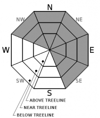
Avalanche danger near and above treeline is CONSIDERABLE today due to the potential for wind slab avalanches. Pay attention to where wind is blowing or has blown snow. A scoured area below a ridgetop indicates a wind loaded slope nearby. Secondary concerns are storm slabs below treeline and cornice falls at and above treeline. Remember, sticking to slopes less than 30 degrees keeps you out of avalanche terrain and still skiing awesome powder! Avalanche danger below treeline is MODERATE.


Avalanche Problem 1: Wind Slab
-
Character ?

-
Aspect/Elevation ?
-
Likelihood ?CertainVery LikelyLikelyPossible
 Unlikely
 -
Size ?HistoricVery LargeLargeSmall

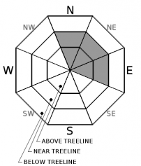
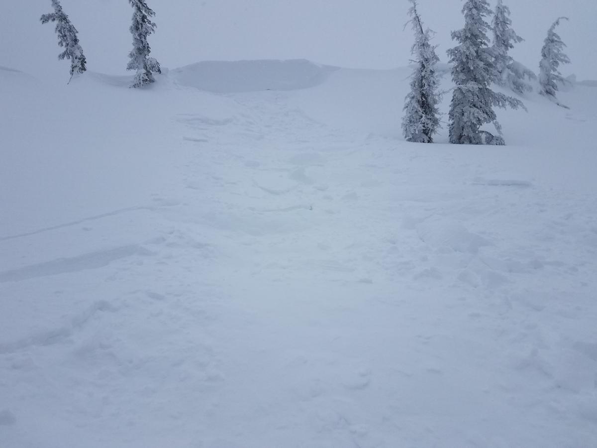
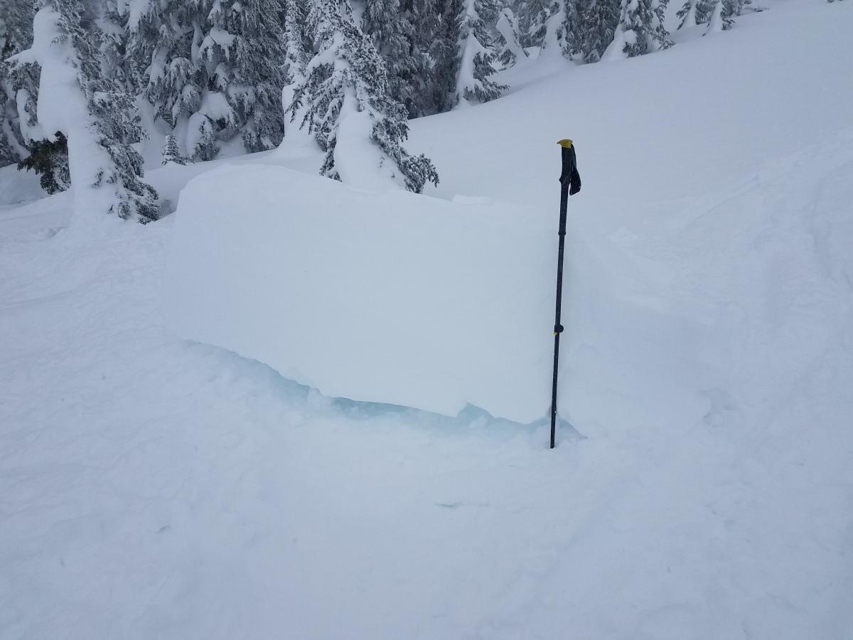
Wind slabs remain the primary concern today on leeward slopes. East facing aspects saw significant wind loading yesterday and with south and southwest winds today, expect to find new slabs forming in north and northeast facing areas. There is still plenty of snow available for transport and at least 6" of new snow predicted for today and tonight so slabs will continue to grow. Easily triggered wind slabs were observed yesterday in three zones within our forecast area. Pay attention to wind direction and look for scoured areas as evidence where loading is occuring. A loaded slope should be avoided today!
Avalanche Problem 2: Cornice
-
Character ?

-
Aspect/Elevation ?
-
Likelihood ?CertainVery LikelyLikelyPossible
Unlikely
-
Size ?HistoricVery LargeLargeSmall
Natural and ski triggered cornice falls were observed yesterday at the top of east facing slopes. These produced small wind slab avalanches below. Winds will be out of the south and southwest today and with more snow on the way, cornices on north and northeast facing aspects will continue to grow. Do not wander out too far on these as they will break even if not overhung. Travel on the windward side of ridges or where you know flat ground exists below you.
Avalanche Problem 3: Storm Slab
-
Character ?

-
Aspect/Elevation ?
-
Likelihood ?CertainVery LikelyLikelyPossible
Unlikely
-
Size ?HistoricVery LargeLargeSmall
Not much evidence of a storm slab problem was encountered yesterday in the backcountry. However, with the new snow today coupled with a warming trend, this remains a concern, as denser snow may be deposited on the existing low density snow. A storm slab forms when snow consolidates over a weaker layer or interface within newly fallen snow. Keep an eye out for these on slopes sheltered from the wind. They are usually the most dangerous above terrain traps. Check for shooting cracks on rollovers or next to tree wells as you travel in safe terrain. These could indicate the presence of a storm slab.
Forecast Discussion
Avalanche danger will remain elevated today due to wind slab avalanches. As this last storm passes through and we enter a period of warmer and more stable weather, expect to see improving conditions, but keep your guard up over the next few days. The snowpack will need a little time to adjust from these new storms.
Wind slab, storm slab and cornice fall are the primary concerns today, but unconsolidated snow atop a melt freeze crust will likely cause some sloughs to occur. These typically are not dangerous, but could sweep you off your feet and take you into undesirable terrain.
Get out and enjoy the last of that blower powder today as warmer weather is coming tonight and tomorrow.
Recent Observations
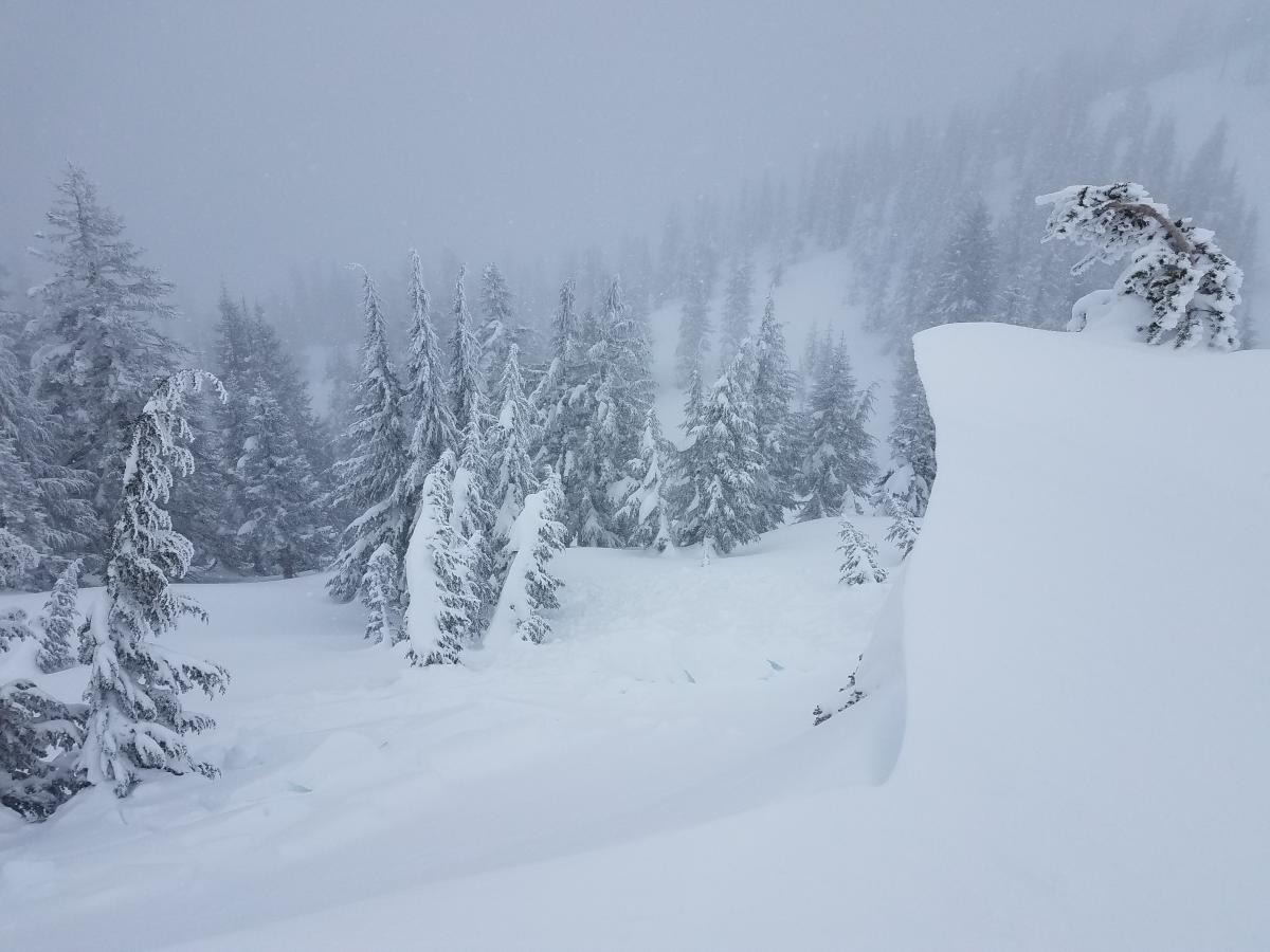
4-12 inches of low density snow was observed on Green Butte, in the Old Ski Bowl, and on Grey Butte yesterday. Wind throughout the day was primarily out of the west and windloading was significant on eastern aspects. Wind slabs were easily triggered and a natural wind slab avalanche occured on an east facing slope of Green Butte.
A natural cornice fall, about 50' in length was seen on the eastern aspect of Grey Butte between the weather station and summit. A large cornice fall was easily ski triggered in the same area producing a small wind slab slide. Similar results were seen on a tour up Green Butte Ridge.
Not much evidence of a storm slab problem was encountered. CT1 and shovel tilt failures were seen in the top 20cm of new snow, but no propagation was seen.
CT22 Sudden Planar and ECTN24 Resistant Planar failures were observed to occur within a density break in the old snow on a NE aspect of Grey Butte. No propagation failures. Deep tap tests yielded no failures down to the old rain crust. Sun exposed areas below 8500' will see new snow atop a melt-freeze crust. Some hard failures occured below this crust near Green Butte, but with no propagation.
Where the melt-freeze crust exists, loose snow sloughs were produced on steeper pitches.
Weather and Current Conditions
Weather Summary
A winter weather warning will remain in effect until 4 p.m. this afternoon. Snow levels will stay low today at about 2000-2500' and will then begin to rise tonight to 4000' and continue to rise tomorrow up to 6000'. We are likely to receive up to another 9" of snow by tomorrow afternoon. After Tuesday, warmer temperatures and scattered rain and snow showers will prevail through the remaining week.
===========================================================
In Mt Shasta City at 0500, we have a current temperature of 28 F.
On Mt Shasta (South Side) in the last 24 hours...
Sand Flat - 6750 ft, the current temperture is 15 degrees F. Temperatures have ranged from 10 F to 23 F. Snow on the ground totals 116 inches with no new snow and about an inch of new and an inch of settlement.
Old Ski Bowl - 7,600ft. the current temperture is 10 degrees F. Temperatures have ranged from 2 F to 16 F. Snow on the ground totals 190 inches with 4 inches of new snow and about an inch of settlement.
Gray Butte - 8,000 feet, the current temperature is 10 degrees F. Temperatures have ranged from 6 F to 18 F. Winds have ranged from West to West Northwest averaging 18 mph with gusts to 49. Highest sustained wind was 32.
Mt Eddy Range (West side of Interstate-5)...
Castle Lake - 5,800 feet, the current temperature is 17 degrees F. Temperatures have ranged from 13 F to 32 F. Snow on the ground totals 114 with 4 inches of new..
Mt Eddy - 6,500 feet, the current temperature is 15 degrees F. Temperatures have ranged from 12 F to 21 F. Snow on the ground measures 107 inches with a 6 inches of new. Winds have been southerly, averaging 2 mph with gusts up to 17.
THIS SEASON PRECIPITATION for MT SHASTA CITY: Since October 1st (the wet season), we have received 43.63 inches of water, normal is 30.77 inches, putting us at 142% of normal. For the month of March, we have received .32 inches of water, normal is 1.27, which is 25 % of normal. And finally for the year of 2017, we received 22.47 inches of water, normal is 15.56 inches, putting us at 144% of normal.
Always check the weather before you attempt to climb Mt Shasta. Further, monitor the weather as you climb. Becoming caught on the mountain in any type of weather can compromise life and limb. Be prepared.
| 0600 temperature: | 12 |
| Max. temperature in the last 24 hours: | 20 |
| Average wind direction during the last 24 hours: | West Northwest |
| Average wind speed during the last 24 hours: | 18 mi/hr |
| Maximum wind gust in the last 24 hours: | 49 mi/hr |
| New snowfall in the last 24 hours: | 0 inches |
| Total snow depth: | 153 inches |
Two Day Mountain Weather Forecast
Produced in partnership with the Medford NWS
| For 7000 ft to 9000 ft | |||
|---|---|---|---|
|
Monday (4 a.m. to 10 p.m.) |
Monday Night (10 p.m. to 4 a.m.) |
Tuesday (4 a.m. to 10 p.m.) |
|
| Weather | Snow showers before 4pm, then snow after 4pm. Breezy. Chance of precipitation 100%. | Snow. Breezy. Chance of precipitation is 90%. | Snow. Breezy. Chance of precipitation is 80%. |
| Temperature (°F) | 30 | 28 | 36 |
| Wind (mi/hr) | Southwest 18-27 mph | Southwest 9-12 mph | South 15-19 mph |
| Precipitation SWE / Snowfall (in) | / 3-7 | / 2-4 | / 2-4 |
| For 9000 ft to 11000 ft | |||
| Monday | Monday Night | Tuesday | |
| Weather | Snow showers before 4pm, then snow after 4pm. Windy. Chance of precipitation 90%. | Snow. Windy. Chance of precipitation is 80%. | Snow. Windy. Chance of precipitation is 80%. |
| Temperature (°F) | 12 | 16 | 25 |
| Wind (mi/hr) | West Southwest 48-50 mph | West 3-7 | West 37-40 mph |
| Precipitation SWE / Snowfall (in) | / 3-7 | / 2-4 | / 2-4 |

