

You are here
Avalanche Advisory for 2017-03-07 06:45:00
- EXPIRED ON March 8, 2017 @ 6:45 amPublished on March 7, 2017 @ 6:45 am
- Issued by Aaron Beverly - Mount Shasta Avalanche Center
Bottom Line
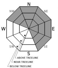
Avalanche danger near and above treeline is HIGH today due to the potential for wind slab avalanches. HIGH means natural and human-triggered avalanches are likely. Added weight from new and blowing snow may stress some windloaded slopes to their breaking point. Stay away from these slopes above, on, and below. Secondary concerns are storm slabs below treeline and cornice falls at and above treeline. Avalanche danger below treeline is CONSIDERABLE.


Avalanche Problem 1: Wind Slab
-
Character ?

-
Aspect/Elevation ?
-
Likelihood ?CertainVery LikelyLikelyPossible
 Unlikely
 -
Size ?HistoricVery LargeLargeSmall

Wind slabs will continue to be a significant concern today on leeward slopes. Winds near and above treeline have been predominantly out of the west but winds were observed at Castle Lake out of the southeast. A skier-triggered avalanche occurred on a northwest aspect at Castle Lake yesterday. Remember an obvious sign of avalanche danger is blowing snow. Another is a human-triggered avalanche. Be careful out there and be mindful of where wind is blowing snow. Avoid those slopes today.
At least 15 inches of snow has been received since Saturday. With moderate to strong winds, leeward slopes may have slabs up to 3' thick or more. These slabs could be sitting atop soft low density snow (a weak layer). A crust or firm layer beneath completes the perfect recipe for an avalanche.
Avalanche Problem 2: Cornice
-
Character ?

-
Aspect/Elevation ?
-
Likelihood ?CertainVery LikelyLikelyPossible
Unlikely
-
Size ?HistoricVery LargeLargeSmall
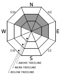
Cornices have and will continue to grow and adjust to the weight of newly fallen and wind transported snow. Give these wide berth as they are likely to break today. A falling cornice could trigger a wind slab avalanche on slopes below greater than 30 degrees. When traveling along ridges, put on your windbreaker, and stick to the windward side. Expect to find cornices on NW, N, NE, and E aspects.
Avalanche Problem 3: Storm Slab
-
Character ?

-
Aspect/Elevation ?
-
Likelihood ?CertainVery LikelyLikelyPossible
Unlikely
-
Size ?HistoricVery LargeLargeSmall
New snow received yesterday remained light and low density. No storm slabs were observed near the Mount Shasta Ski Park. However, some settlement has begun, and a warming trend with new snow could create an upside down configuration where a firmer or wetter/heavier slab-like layer forms on top of the looser snow beneath. You may encounter these today on slopes sheltered from the wind, particulary below treeline. Ski cut around tree wells and rollovers above short steep drops to test for the presence of this problem.
Forecast Discussion
We received 6-10 inches of snow since Sunday night. Yesterday saw plenty of wind transport of snow and with moderate to strong winds today, loading of leeward slopes will continue. With a few inches more expected today that could be wetter and heavier, these slopes and the cornices above them may have difficulty adjusting to the new weight. It is likely that we'll see a natural avalanche today. Stay off of wind loaded slopes above 30 degrees and be careful not to be right below one.
Warmer weather and decreasing precipitation will likely lead to a fairly rapid stablization of the snowpack over the next few days.
Recent Observations
3-4 inches of snow has fallen in the last 24 hours and 6-8" since Sunday night. Winds were strong yesterday, out of the west and west southwest, and transporting plenty of snow. At the ski park, 4" was received between 8 a.m. and 4 p.m. and at least double that was observed in wind loaded areas.
A skier triggered an avalanche yesterday on Left Peak (NW aspect) at Castle Lake that partially buried the skier. Slab slid on a layer in the new storm snow. Winds were moderate and out of the SE. See posted observation.
Weather and Current Conditions
Weather Summary
A winter weather advisory will be in effect until 4 p.m. this afternoon. Expect rising snow levels today and tomorrow as a warmer air flows into the area from the west. Weather data varies a bit as to what the exact levels will be. Anywhere from 3500' - 6000' today. By tomorrow, levels will definitely be above 6000' and may even as high as 7000'. Powder hounds will definitely want to get out this morning to enjoy the last of that light low-density snow.
===========================================================
In Mt Shasta City at 0500, we have a current temperature of 35 F.
On Mt Shasta (South Side) in the last 24 hours...
Sand Flat - 6750 ft, the current temperture is 23 degrees F. Temperatures have ranged from 15 F to 25 F. Snow on the ground totals 120 inches with 3 inches of new snow.
Old Ski Bowl - 7,600ft. the current temperture is 19 degrees F. Temperatures have ranged from 2 F to 20 F. Snow on the ground totals 198 inches with 3 inches of new snow and an inch of settlement.
Gray Butte - 8,000 feet, the current temperature is 18 degrees F. Temperatures have ranged from 10 F to 20 F. Winds have ranged from West to West Southwest and West Northwest averaging 18 mph with gusts to 35. Highest sustained wind was 21.
Mt Eddy Range (West side of Interstate-5)...
Castle Lake - 5,800 feet, the current temperature is 24 degrees F. Temperatures have ranged from 15 F to 32 F. Snow on the ground totals 120 with over 3 inches of new.
Mt Eddy - 6,500 feet, the current temperature is 22 degrees F. Temperatures have ranged from 15 F to 26 F. Snow on the ground measures 114 inches with a 2 inches of new. Winds have been southerly, averaging 2 mph with gusts up to 16.
THIS SEASON PRECIPITATION for MT SHASTA CITY: Since October 1st (the wet season), we have received 43.67 inches of water, normal is 31 inches, putting us at 141% of normal. For the month of March, we have received .36 inches of water, normal is 1.5, which is 24 % of normal. And finally for the year of 2017, we received 22.51 inches of water, normal is 15.79 inches, putting us at 143% of normal.
Always check the weather before you attempt to climb Mt Shasta. Further, monitor the weather as you climb. Becoming caught on the mountain in any type of weather can compromise life and limb. Be prepared.
| 0600 temperature: | 21 |
| Max. temperature in the last 24 hours: | 22 |
| Average wind direction during the last 24 hours: | West Southwest |
| Average wind speed during the last 24 hours: | 18 mi/hr |
| Maximum wind gust in the last 24 hours: | 35 mi/hr |
| New snowfall in the last 24 hours: | 6 inches |
| Total snow depth: | 159 inches |
Two Day Mountain Weather Forecast
Produced in partnership with the Medford NWS
| For 7000 ft to 9000 ft | |||
|---|---|---|---|
|
Tuesday (4 a.m. to 10 p.m.) |
Tuesday Night (10 p.m. to 4 a.m.) |
Wednesday (4 a.m. to 10 p.m.) |
|
| Weather | Snow likely. Cloudy. Breezy. Chance of precipitation is 70%. | Snow showers likely before 4am, then a chance of rain and snow showers. Mostly cloudy. Breezy. Chance of precipitation is 70%. | Rain and snow likely, mainly after 10am. Mostly cloudy. Breezy. Chance of precipitation is 60%. |
| Temperature (°F) | 35 | 30 | 41 |
| Wind (mi/hr) | South 16 mph | South 17 mph | South 13 mph |
| Precipitation SWE / Snowfall (in) | / 2-4 | / 2-4 | / <.5 |
| For 9000 ft to 11000 ft | |||
| Tuesday | Tuesday Night | Wednesday | |
| Weather | Snow likely. Cloudy. Windy. Chance of precipitation is 70%. | Snow likely before 10pm, then snow showers likely, mainly between 10pm and 4am. Mostly cloudy. Windy. Chance of precipitation is 70%. | A chance of snow showers before 10am, then snow likely after 10am. Mostly cloudy. Windy. Chance of precipitation is 60%. |
| Temperature (°F) | 27 | 21 | 27 |
| Wind (mi/hr) | West 43 mph | West 3-7 | West 43 mph |
| Precipitation SWE / Snowfall (in) | / 3-7 | / 2-4 | / 1 |

