

You are here
Avalanche Advisory for 2017-03-18 06:31:18
- EXPIRED ON March 19, 2017 @ 6:31 amPublished on March 18, 2017 @ 6:31 am
- Issued by Nick Meyers - Shasta-Trinity National Forest
Bottom Line
LOW danger this morning may increase to MODERATE danger later today. Strong southwest to northwest winds and new snow will contribute to fresh wind slab formation above treeline. This problem will be confined to primarily the upper slopes of Mt Shasta, above 9,000 feet. Below and near treeline, the avalanche danger will remain LOW.


Avalanche Problem 1: Wind Slab
-
Character ?

-
Aspect/Elevation ?
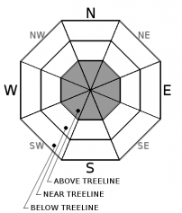
-
Likelihood ?CertainVery LikelyLikelyPossible
 Unlikely
 -
Size ?HistoricVery LargeLargeSmall

Strong southwest winds in addition to several inches of new snow could contribute to small, isolated wind slab formation above treeline, primarily > 9,000 feet. Winds will switch to northwest this afternoon and may continue to blow fresh snow around to different aspects. Again, this avalanche problem is only expected well above the rain/snow level, in areas where most people will not venture today due to poor visibility. If you come across sudden pillows of new snow, visible blowing snow, shooting cracks and/or recent avalanches... these will be your best indicator that you may be entering an area where this avalanche problem is a concern.
Forecast Discussion
Just shy of .5 inches of rain on snow has occurred overnight, up to 8,500 feet. While minor loose-wet instabilities are possible, it is unlikely to see this avalanche problem causing concern for backcountry riders today.
Recent Observations
We have received .42 inches of rain on snow overnight, recorded by the Old Ski Bowl weather stations. The rain began at 2100 hrs. Snow levels have remained upwards of 8,500 to 9,000 feet. Upper elevations may have a few inches of new snow however windy conditions have likely kept things scoured. Temperatures are several degrees warmer this morning. A tour of the east side of the forecast area yesterday revealed nothing notable.... old, broken cornices, a few very small, isolated loose-wet slides, soft corn snow and an otherwise strong, isothermal snowpack. Winds remained moderate for most of the day out of the southwest as high clouds began to filter in throughout the day. Mt Shasta remained obscured in a lenticular cloud.
Weather and Current Conditions
Weather Summary
Expect periods of light to moderate rain today. The front upon us will push east of the Cascades by late afternoon. Wind advisories remain in place. Winds will shift from southerly to northerly and when they do, you'll know when the front has moved through! Precipitation amounts will reach no more than a half inch of water with snow levels around 7,500 to 8,000 feet. Above treeline we could see a couple inches of fresh snow with perhaps a bit more up higher, however winds will likely keep things pretty scoured. Mostly cloudy skies and light precipitation is expected for Sunday.
===========================================================
In Mt Shasta City at 0500, we have a current temperature of 49 F.
On Mt Shasta (South Side) in the last 24 hours...
Sand Flat - 6750 ft, the current temperture is 37 degrees F. Temperatures have ranged from 32 F to 45 F. Snow on the ground totals 99 inches with no new snow and 2 inches of settlement.
Old Ski Bowl - 7,600ft. the current temperature is 35 degrees F. Temperatures have ranged from 35 F to 45 F. Snow on the ground totals 172 inches with only rain on snow (.42" - H20) and 3 inches of settlement.
Gray Butte - 8,000 feet, the current temperature is 35 degrees F. Temperatures have ranged from 32 F to 40 F. Winds have averaged 15-20 mph with gusts to 42 mph, blowing out of the northwest until late last night, switching to southwest.
Mt Eddy Range (West side of Interstate-5)...
Castle Lake - 5,800 feet, the current temperature is 38 degrees F. Temperatures have ranged from 37 F to 54 F. Snow on the ground totals 98 inches with no new snow and 2 inches of settlement.
Mt Eddy - 6,500 feet, the current temperature is 38 degrees F. Temperatures have ranged from 36 F to 43 F. Snow on the ground measures 90 inches with no new snow and 1 inch of settlement. Winds have averaged 2 mph with gusts to 12 mph, south/southwest.
THIS SEASON PRECIPITATION for MT SHASTA CITY: Since October 1st (the wet season), we have received 43.97 inches of water, normal is 33.38 inches, putting us at 131% of normal. For the month of March, we have received .66 inches of water, normal is 3.88 inches, which is 17% of normal. And finally for the year of 2017, we received 22.81 inches of water, normal is 18.17 inches, putting us at 125% of normal.
Always check the weather before you attempt to climb Mt Shasta. Further, monitor the weather as you climb. Becoming caught on the mountain in any type of weather can compromise life and limb. Be prepared.
| 0600 temperature: | 37 |
| Max. temperature in the last 24 hours: | 45 |
| Average wind direction during the last 24 hours: | Northwest, switching to southwest |
| Average wind speed during the last 24 hours: | 10-15 mi/hr |
| Maximum wind gust in the last 24 hours: | 20 mi/hr |
| New snowfall in the last 24 hours: | .42" - RAIN inches |
| Total snow depth: | 99 (-2) inches |
Two Day Mountain Weather Forecast
Produced in partnership with the Medford NWS
| For 7000 ft to 9000 ft | |||
|---|---|---|---|
|
Saturday (4 a.m. to 10 p.m.) |
Saturday Night (10 p.m. to 4 a.m.) |
Sunday (4 a.m. to 10 p.m.) |
|
| Weather | Rain before 11am, then rain and snow. Windy. Chance of precipitation is 100%. | Rain and snow showers. Breezy. Chance of precipitation is 90%. | Showers likely, mainly before 11am. Mostly cloudy. Chance of precipitation is 70%. |
| Temperature (°F) | 47 | 35 | 47 |
| Wind (mi/hr) | South 15-20 mph | Southwest 10-15 mph | South 5-10 mph |
| Precipitation SWE / Snowfall (in) | / 0-.5 | / 0-.5 | / 0-.5 |
| For 9000 ft to 11000 ft | |||
| Saturday | Saturday Night | Sunday | |
| Weather | Snow.Windy. Wind chill values as low as zero. Chance of precipitation is 100%. | Snow showers. Windy, Chance of precipitation is 90%. | Snow showers likely, mainly before 11am. Mostly cloudy. Windy. Chance of precipitation is 70%. |
| Temperature (°F) | 26 | 23 | 25 |
| Wind (mi/hr) | Southwest 50-55 mph | Southwest 4-6 | Southwest 15-20 mph |
| Precipitation SWE / Snowfall (in) | / 4-6 | / 1-3 | / 1-2 |

