

You are here
Avalanche Advisory for 2017-03-20 06:21:28
- EXPIRED ON March 21, 2017 @ 6:21 amPublished on March 20, 2017 @ 6:21 am
- Issued by Andrew Kiefer - Mt Shasta Avalanche Center
Bottom Line
The avalanche danger is MODERATE on all aspects above treeline. Variable winds have redistributed the recent snow in the alpine, creating fresh wind slabs on lee slopes and terrain features, primarily above 9000ft. LOW avalanche danger exists near treeline and below treeline.


Avalanche Problem 1: Wind Slab
-
Character ?

-
Aspect/Elevation ?
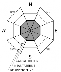
-
Likelihood ?CertainVery LikelyLikelyPossible
 Unlikely
 -
Size ?HistoricVery LargeLargeSmall

Strong and variable winds have redistributed the new snow in the alpine, forming isolated wind slabs in leeward terrain, primarily above 9000ft on Mount Shasta. Recent winds have blown from several directions including SE-S-SW-W-NW. Although N and E aspects are most suspect, all aspects above treeline should be evaluated for the presence of fresh wind slabs. Blowing snow was visible above treeline yesterday near the 8500-9000ft level and higher. Continue to watch for evidence of wind-transported snow, and avoid slopes 35 degrees and steeper where the wind slab problem exists.
Forecast Discussion
The stormy pattern will continue for now, and tonight and tomorrow look to deliver the most significant precipitation event of the week. Freezing levels will remain high during this time, and the avalanche concerns will likely be confined to upper elevation terrain on Mount Shasta.
Recent Observations
No significant signs of instability were observed yesterday in the Old Ski Bowl up to 9500ft. Light rain fell throughout the morning at Bunny flat and up to 7500ft. Above this elevation, the rain transitioned to snow, and between 7500-9500ft, 10-15cm of new snow had fallen overnight. The new snow was wet and heavy, and bonding very well to the old snow surface. Near the 8500ft level, the snow became noticeable drier. Blowing snow and small, loose-dry sluffing was observed on the east aspect of Green Butte. No wind slabs were present in the Old Ski Bowl. Westerly winds became moderate to strong above 8500ft, and wind slab development is likely above the 9000ft level, but was not observed. The upper snowpack is comprised of moist and wet snow, and is very uniform. Skies were fully obscured until 1130 when the clouds lifted to 12000ft for a brief period.
Weather and Current Conditions
Weather Summary
A low-pressure system is developing off of the northern California coast, and will bring heavy precipitation to the advisory area tonight and tomorrow. For today, rain and snow showers are likely before 11am before becoming scattered in the afternoon. Southerly winds will increase throughout the day, while little to no snow accumulation is expected. Beginning late tonight, precipitation will increase, and over 1 inch of water is expected by tomorrow. Freezing levels will remain near 7000ft for the next 24 hours, and definitive snow levels will likely be near 8000-8500ft.
===========================================================
In Mt Shasta City at 0500, we have a current temperature of 45 F.
On Mt Shasta (South Side) in the last 24 hours...
Sand Flat - 6,750 ft, the current temperture is 36 degrees F. Temperatures have ranged from 34 F to 40 F. Snow on the ground totals 97 inches with a trace of new snow and 1.4 inches of snow water equivalent.
Old Ski Bowl - 7,600ft. the current temperature is 33 degrees F. Temperatures have ranged from 32 F to 39 F. Snow on the ground totals 173 inches with 2 inches of settlement and .12 inches of snow water equivalent.
Gray Butte - 8,000 feet, the current temperature is 32 degrees F. Temperatures have ranged from 31 F to 35 F. Winds have averaged 5-15 mph with gusts to 35 mph, variable in direction, but blowing primarily out of the west/southwest.
Mt Eddy Range (West side of Interstate-5)...
Castle Lake - 5,800 feet, the current temperature is 36 degrees F. Temperatures have ranged from 36 F to 48 F. Snow on the ground totals 93 inches with no new snow and 1 inch of settlement due to rain on snow.
Mt Eddy - 6,500 feet, the current temperature is 37 degrees F. Temperatures have ranged from 35 F to 39 F. Snow on the ground measures 86 inches with 1 inch of new snow. Winds have averaged 1-3 mph with gusts to 16 mph, south/southeast shifting south/southwest.
THIS SEASON PRECIPITATION for MT SHASTA CITY: Since October 1st (the wet season), we have received 44.92 inches of water, normal is 33.72 inches, putting us at 133% of normal. For the month of March, we have received 1.62 inches of water, normal is 4.22 inches, which is 38% of normal. And finally for the year of 2017, we received 23.76 inches of water, normal is 18.51 inches, putting us at 128% of normal.
Always check the weather before you attempt to climb Mt Shasta. Further, monitor the weather as you climb. Becoming caught on the mountain in any type of weather can compromise life and limb. Be prepared.
| 0600 temperature: | 36 |
| Max. temperature in the last 24 hours: | 40 |
| Average wind direction during the last 24 hours: | Southwest |
| Average wind speed during the last 24 hours: | 5-10 mi/hr |
| Maximum wind gust in the last 24 hours: | 20 mi/hr |
| New snowfall in the last 24 hours: | trace inches |
| Total snow depth: | 97 inches |
Two Day Mountain Weather Forecast
Produced in partnership with the Medford NWS
| For 7000 ft to 9000 ft | |||
|---|---|---|---|
|
Monday (4 a.m. to 10 p.m.) |
Monday Night (10 p.m. to 4 a.m.) |
Tuesday (4 a.m. to 10 p.m.) |
|
| Weather | A mix of rain and snow showers likely, mainly before 11am. Breezy. Chance of precipitation 60%. | A mix of rain and snow, becoming all rain after 11pm. The rain could be heavy at times. Breezy. Chance of precipitation 100%. | Rain and snow showers. The rain and snow could be heavy at times. Some thunder is also possible. Breezy. Chance of precipitation 100%. |
| Temperature (°F) | 39 | 36 | 40 |
| Wind (mi/hr) | South/Southeast 23-28 mph | South 24-33 mph | South 18-23 mph |
| Precipitation SWE / Snowfall (in) | / 0-.25 | / 0-.5 | / 1-3 |
| For 9000 ft to 11000 ft | |||
| Monday | Monday Night | Tuesday | |
| Weather | Snow likely before 11am, then scattered snow showers after 11am. Chance of precipitation 60%. | Snow showers before 11pm, then snow after 11pm. The snow could be heavy at times. Windy. Chance precipitation 100%. | Snow showers. The snow could be heavy at times. Some thunder is also possible. Chance of precipitation 100%. |
| Temperature (°F) | 27 | 23 | 23 |
| Wind (mi/hr) | South/Southwest 32-42 mph | South/Southwest 1-3 | South/Southwest 60-70 mph |
| Precipitation SWE / Snowfall (in) | / 1-3 | / 12-18 | / 11-17 |

