

You are here
Avalanche Advisory for 2017-03-22 07:45:32
- EXPIRED ON March 23, 2017 @ 7:45 amPublished on March 22, 2017 @ 7:45 am
- Issued by Aaron Beverly - Mount Shasta Avalanche Center
Bottom Line
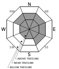
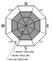
Avalanche danger is CONSIDERABLE near and above treeline. With 11 inches of new snow and poor bonding between the new snow and an underlying crust, wind slabs on leeward slopes will be sensitive to human trigger. With 4 inches of additional snow today and continued wind transport, natural avalanches are possible. Watch out for sloughing snow as well. Though less likely, isolated slabs could be encountered below treeline on slopes greater than 35 degrees. Below treeline, avalanche danger is MODERATE.


Avalanche Problem 1: Wind Slab
-
Character ?

-
Aspect/Elevation ?
-
Likelihood ?CertainVery LikelyLikelyPossible
 Unlikely
 -
Size ?HistoricVery LargeLargeSmall

Wind slabs were observed yesterday on southeast, east, and northeast aspects near and above treeline. These slabs are sitting on top of a weak layer of graupel which is sitting atop a crust. This is the perfect recipe for an avalanche. These slabs were easily triggered and will likely become more senstive with the addition of 7 inches of snow since yesterday afternoon and 4 more inches today. Slabs will continue to grow today with plenty of snow available for transport and moderate winds expected. Wind slabs above 9000 ft are likely to exist on all aspects. Watch for blowing snow and cornice formation as indications of wind slab development. Look for shooting cracks as you travel in safe terrain. Avoid lee slopes 35 degrees and steeper where recent wind loading has occurred.
Avalanche Problem 2: Loose Dry
-
Character ?

-
Aspect/Elevation ?
-
Likelihood ?CertainVery LikelyLikelyPossible
Unlikely
-
Size ?HistoricVery LargeLargeSmall
New light snow mixed with graupel combined with falling snow levels has prevented a good bond from forming at the new / old snow interface near and above treeline. In less wind effected areas on slopes having angles 30-35 degrees or more, this could lead to sloughing snow. It is unlikely that this type of avalanche will be hazardous, but it could sweep an unaware skier of their feet.
Forecast Discussion
Below treeline, snowpack should be right side up with the new snow bonding well to old snow. Since 7 inches of new snow was received since yesterday afternoon and up to 4 inches of new today coupled with moderate winds and lowering snow levels, keep an eye out for wind slabs on lee slopes greater than 35 degrees below treeline. A wide spread crust below new light snow mixed with graupel WILL make wind slabs near and above treeline sensitive to human trigger.
Get out and enjoy the powder skiing today!
Recent Observations
Snow levels came down to about 5500' yesterday afternoon. Along Green Butte Ridge, snow was heavy and dense up to about 7500'. Very little wind effect was observed below treeline. New snow ranged from 2-5 inches. New snow was bonding well to the old snow below treeline.
Conditions changed abrubtly near treeline with about 2-4 inches of light snow on top of a melt freeze / rain crust. Shallow wind slabs (about 4 inches thick) were observed on east / southeast facing aspects. Though the aftertnoon storm was coming in from the southeast, surface winds were blowing from the northwest. Powder bowl and sun bowl were wind loaded. Two skiers reported triggering small soft slab avalanches in Sun Bowl. New snow was not bonded well to the underlying crust. A thin layer of graupel (PPgp) separated the crust from a layer mixed with wind-broken precipitation particles (DFbk) and graupel. Both soft slab and loose dry avalanches seemed possible on steep aspects in Sun Bowl.
Weather and Current Conditions
Weather Summary
Over 11 inches of snow was received at 7600' with moderate and steady south, southwest, and west winds.
A cold front will move through today bringing more precipitation and the possibility of thunderstorms this afternoon. Cooler and dryer conditions will follow until tomorrow afternoon when a warm front will bring in more precipitation. An inch of precipitation is expected through the weekend. Expect snow levels to stay below 5000' until early next week.
We are quickly catching up to normal precipitation for the month of March. We are at 80% of normal. Long term climate models predict dryer than normal conditions for the next month.
===========================================================
In Mt Shasta City at 0500, we have a current temperature of 40 F.
On Mt Shasta (South Side) in the last 24 hours...
Sand Flat - 6,750 ft, the current temperture is 29 degrees F. Temperatures have ranged from 29 F to 34 F. Snow on the ground totals 109 inches with 10.5 inches of new snow.
Old Ski Bowl - 7,600ft. the current temperature is 26 degrees F. Temperatures have ranged from 26 F to 32 F. Snow on the ground totals 188 inches with 11 inches of new snow.
Gray Butte - 8,000 feet, the current temperature is 27 degrees F. Temperatures have ranged from 26 F to 32 F. Winds have averaged 15 mph with gusts to 42 mph, blowing from the south, west, and southwest.
Mt Eddy Range (West side of Interstate-5)...
Castle Lake - 5,800 feet, the current temperature is 31 degrees F. Temperatures have ranged from 31 F to 38 F. Snow on the ground totals 94 inches with about 2.5 inches new snow and 1 inch of settlement due to rain on snow.
Mt Eddy - 6,500 feet, the current temperature is 29 degrees F. Temperatures have ranged from 29 F to 37 F. Snow on the ground measures 90 inches with 3 inches of new snow. Winds have been southerly averaging 2 mph with gusts up to 17 mph.
THIS SEASON PRECIPITATION for MT SHASTA CITY: Since October 1st (the wet season), we have received 46.96 inches of water, normal is 34.04 inches, putting us at 138% of normal. For the month of March, we have received 3.65 inches of water, normal is 4.54 inches, which is 80% of normal. And finally for the year of 2017, we received 25.80 inches of water, normal is 18.83 inches, putting us at 137% of normal.
Always check the weather before you attempt to climb Mt Shasta. Further, monitor the weather as you climb. Becoming caught on the mountain in any type of weather can compromise life and limb. Be prepared.
| 0600 temperature: | 29 |
| Max. temperature in the last 24 hours: | 34 |
| Average wind direction during the last 24 hours: | South - Southwest |
| Average wind speed during the last 24 hours: | 15 mi/hr |
| Maximum wind gust in the last 24 hours: | 42 mi/hr |
| New snowfall in the last 24 hours: | 10.5 inches |
| Total snow depth: | 109 inches |
Two Day Mountain Weather Forecast
Produced in partnership with the Medford NWS
| For 7000 ft to 9000 ft | |||
|---|---|---|---|
|
Wednesday (4 a.m. to 10 p.m.) |
Wednesday Night (10 p.m. to 4 a.m.) |
Thursday (4 a.m. to 10 p.m.) |
|
| Weather | Snow showers. Some thunder possible. Breezy. Chance of precipitation is 90% | A 40 percent chance of snow showers before 11pm. Mostly cloudy. Light and variable wind. | Increasing clouds. |
| Temperature (°F) | 35 | 24 | 38 |
| Wind (mi/hr) | Southwest 10-15 mph | Northwest 5-10 mph | South 10-15 mph |
| Precipitation SWE / Snowfall (in) | / 2-4 | / <1 | / 0 |
| For 9000 ft to 11000 ft | |||
| Wednesday | Wednesday Night | Thursday | |
| Weather | Snow showers. Some thunder possible. Windy. Chance of precipitation is 90%. | A 40 percent chance of snow showers, mainly before 11pm. Mostly cloudy. | Increasing clouds. Windy. |
| Temperature (°F) | 13 | 13 | 24 |
| Wind (mi/hr) | Southwest 20-25 mph | West 3-5 | West 15-20 mph |
| Precipitation SWE / Snowfall (in) | / 3-5 | / <1 | / 0 |

