

You are here
Avalanche Advisory for 2017-04-13 06:14:43
- EXPIRED ON April 14, 2017 @ 6:14 amPublished on April 13, 2017 @ 6:14 am
- Issued by Aaron Beverly - Mount Shasta Avalanche Center
Bottom Line
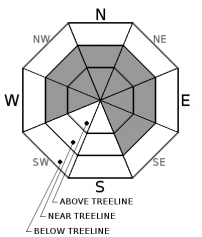
Avalanche danger is CONSIDERABLE near and above treeline due to the presence of wind slabs. Human triggered avalanches are likely and natural avalanches are possible. Evaluate the snowpack carefully and choose your routes wisely. Stay clear of wind loaded aspects greater than 35 degrees. Though unlikely, a secondary concern is storm slabs in sheltered areas. Avalanche danger below treeline is MODERATE.


Avalanche Problem 1: Wind Slab
-
Character ?

-
Aspect/Elevation ?
-
Likelihood ?CertainVery LikelyLikelyPossible
 Unlikely
 -
Size ?HistoricVery LargeLargeSmall

Wind slabs are the primary concern near and above treeline. Moderate winds are predicted today and with plenty of dry snow available for transport, new slabs may form and existing ones could continue to grow. Look for new slabs primarily on east and southeast facing slopes. Older slabs that formed since Tuesday would exist mainly on NW-N-NE aspects. Mountain winds can be unpredicatable, though, so pay attention when traveling in the backcountry. Blowing snow and textured snow surfaces are indicators of current or recent wind loading. Wind slabs will most likely be triggered on leeward slopes 35 degrees and steeper that are unsupported, have a convex shape, or that are just below ridgelines.
Avalanche Problem 2: Storm Slab
-
Character ?

-
Aspect/Elevation ?
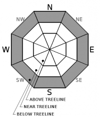
-
Likelihood ?CertainVery LikelyLikelyPossible
Unlikely
-
Size ?HistoricVery LargeLargeSmall
With a foot of snow received since 1:00 p.m. yesterday, storm slabs might be an issue today in sheltered areas protected from the wind. Snow was bonding well to old snow surfaces yesterday early in the storm, so storm slabs are unlikely, but evaluate the snowpack as you travel in safe terrain. If surface snow is exhibiting slab-like characteristics and slides easily within the new snow or on the old snow surface, a storm slab problem may exist. Be prepared to change your plan to avoid steep terrain where these slabs will be sensitive to human trigger.
A storm slab is a soft cohesive layer of new snow that breaks within the storm snow or on the old snow surface. Storm slabs are most dangerous on slopes with terrain traps, such as timber, gullies, over cliffs, or terrain features that make it difficult for a rider to escape off the side.
Forecast Discussion
The storm slab problem witnessed on Tuesday was short lived. Storm slabs seem unlikely today, but a foot of new snow has fallen in the last 14 hours with a few more inches possible today. This is a red flag for avalanches and so we are keeping storm slabs up as a secondary concern.
As usual, the primary concern today is for wind slabs near and above treeline. We have received 19 inches of snow since Tuesday. Winds have been south and southwest and west and at times have reached sustained speeds of over 20 mph near treeline. This is enough to transport snow onto the upper parts of leeward slopes. If venturing near or onto slopes that are greater than 35 degrees today, evaluate the snowpack carefully.
We will issue our last avalanche advisory of the season this Sunday, April 16th.
Recent Observations
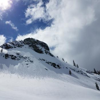
A quick tour along Green Butte Ridge yesterday showed no signs of the storm slab problem witnessed Tuesday on Grey Butte. Snow was bonding well to the old snow surface. The system that came through yesterday afternoon started warm and quickly got cold with snow levels dropping from 5800' down to 4000'. Snow at Bunny Flat was moist to wet and transitioned to moist to dry around 7600'. Winds were light and snow below treeline had not been wind effected, but there was plenty of new dry snow available for transport (3-5 inches). Skiing was sublime.
Overnight, Grey Butte weather station has reported moderate winds, averaging 20 mph, blowing from the west. Winds have been mostly from the south and southwest throughout the precipitation received since Tuesday.
Over the last week, we have received nearly 47 inches of snow. Since Tuesday, 19 inches.
Weather and Current Conditions
Weather Summary
Unstable conditions will continue today with showery weather expected through 11 p.m. The cold air mass following the frontal system that came through last night will keep things cool today and tonight with snow levels expected near town. This will give way to slighty warmer conditions this weekend. We should get a break in action Friday and Saturday. Several more systems are expected to move in beginning Sunday afternoon. Climate predition models show normal temperatures and above average precipitation for the next month. It's not over yet ...
-------------------------
In Mt Shasta City at 0500, we have a current temperature of 33 F
On Mt Shasta (South Side) in the last 24 hours...
Sand Flat - 6,750 ft. The current temperature is 25 degrees F. Temperatures have ranged from 25 F to 33 F. Snow on the ground totals 137 inches with 12 inches of new and a half inch of settlement.
Old Ski Bowl - 7,600ft. The current temperature is 22 degrees F. Temperatures have ranged from 22 F to 31 F. Snow on the ground totals 222 inches with 10 inches of new and 1 inch of settlement.
Grey Butte - 8,000 feet. The current temperature is 21 degrees F. Temperatures have ranged from 21 F to 30 F. Winds have ranged from 11-21 mph with gusts to 42 mph, blowing from the south and south southwest, then west overnight.
Mt Eddy Range (West side of Interstate-5)...
Castle Lake - 5,800 feet. The current temperature is 25 degrees F. Temperatures have ranged from 25 F to 34 F. Snow on the ground totals 118 inches with 5 inches of new and 2 inches of settlement.
Mt Eddy - 6,500 feet, the current temperature 22 degrees F. Temperatures have ranged from 22 F to 31 F. Snow on the ground measures 117 inches with 13 inches of new and 1 inch of settlement. Southerly winds have averaged 2 mph with gusts up to 20 mph.
THIS SEASON PRECIPITATION for MT SHASTA CITY: Since October 1st (the wet season), we have received 56.33 inches of water, normal is 36.77 inches, putting us at 153% of normal. For the month of April, we have received 6.87 inches of water, normal is 1.31 inches, which is 524% of normal. And finally for the year of 2017, we received 35.17 inches of water, normal is 21.56 inches, putting us at 163% of normal.
Always check the weather before you attempt to climb Mt Shasta. Further, monitor the weather as you climb. Becoming caught on the mountain in any type of weather can compromise life and limb. Be prepared.
| 0600 temperature: | 22 |
| Max. temperature in the last 24 hours: | 31 |
| Average wind direction during the last 24 hours: | S-SW-W |
| Average wind speed during the last 24 hours: | 11-21 mi/hr |
| Maximum wind gust in the last 24 hours: | 42 mi/hr |
| New snowfall in the last 24 hours: | 12 inches |
| Total snow depth: | 137 inches |
Two Day Mountain Weather Forecast
Produced in partnership with the Medford NWS
| For 7000 ft to 9000 ft | |||
|---|---|---|---|
|
Thursday (4 a.m. to 10 p.m.) |
Thursday Night (10 p.m. to 4 a.m.) |
Friday (4 a.m. to 10 p.m.) |
|
| Weather | Snow showers. Some thunder is also possible. Chance of precipitation is 100%. | Snow showers, mainly before 11pm. Chance of precipitation is 90%. | Partly sunny. |
| Temperature (°F) | 32 | 17 | 33 |
| Wind (mi/hr) | South 10-15 mph | West 10-15 mph | Southwest 5 mph |
| Precipitation SWE / Snowfall (in) | / 1-3 | / <1 | / 0 |
| For 9000 ft to 11000 ft | |||
| Thursday | Thursday Night | Friday | |
| Weather | Snow showers. The snow could be heavy at times. Windy. Chance of precipitation is 100%. | Snow showers, mainly before 11pm. Chance of precipitation is 90%. | Partly sunny. |
| Temperature (°F) | 14 | 9 | 12 |
| Wind (mi/hr) | Southwest then West 18-28 mph | West 2-3 | West 5-10 mph |
| Precipitation SWE / Snowfall (in) | / 2-3 | / <1 | / 0 |

