

You are here
Avalanche Advisory for 2017-12-19 07:00:41
- EXPIRED ON December 20, 2017 @ 7:00 amPublished on December 19, 2017 @ 7:00 am
- Issued by Andrew Kiefer - Mt Shasta Avalanche Center
Bottom Line
LOW avalanche danger continues throughout the advisory area today. The National Weather Service has issued a WINTER WEATHER ADVISORY IN EFFECT FROM 1PM THIS AFTERNOON TO 7AM WEDNESDAY. The avalanche danger will rise overnight. Wind slabs are expected to form near and above treeline by tomorrow.


Avalanche Problem 1: Normal Caution
-
Character ?

-
Aspect/Elevation ?
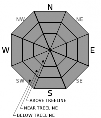
-
Likelihood ?CertainVery LikelyLikelyPossible
 Unlikely
 -
Size ?HistoricVery LargeLargeSmall

Snowpack stability has been very good, and avalanche conditions will remain generally safe until snow begins to accumulate. Exercise normal caution for today, and closely monitor conditions as they change over the next 24 hours. The weather will deteriorate, and new snow and wind are expected to form wind slabs and raise the avalanche danger overnight. Track snow surface conditions if you head out into the backcountry today, and prioritize gathering observations and making informed decisions if you venture out tomorrow.
Forecast Discussion
We are on the cusp of change. For over two weeks, the “Ridiculously Resilient Ridge” of high pressure has dominated our weather pattern and delivered unseasonably warm and dry conditions. Records show that December is the second wettest month of our wet season, and missing out on precipitation this month is a big setback. Fortunately, we have a storm coming late this afternoon, which should spice up conditions and make it feel like winter. Be prepared for rising avalanche danger in the backcountry. The new snow will not bond well to the old snow surface. If the forecast verifies, wind slabs will form near and above treeline and will be reactive to the weight of a person.
Recent Observations
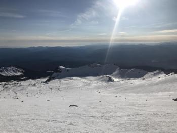
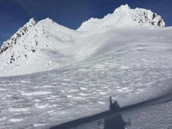
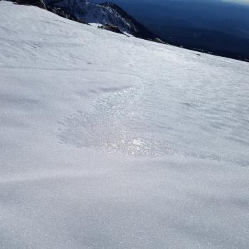
Spring-like conditions yesterday made for a pleasant outing on the south side of Mount Shasta. High temperatures hit the mid 40’s between 7,000-9,000ft. Winds were much calmer than expected, blowing at moderate speeds out of the northwest.
Warm temperatures have taken a toll on snow coverage. Snow height ranges from 1-2ft near and below treeline, while above treeline 2-3ft exists. Many ridgelines, wind exposed areas, and steep due south facing slopes are completely bare. The most notable example is Sun Bowl - no snow exists in a large portion of the upper bowl. Melt-freeze crusts and wind-eroded snow formations were the primary surface conditions observed yesterday. Sun softened open south facing slopes up to 10,000ft. Snowpack stability was very good, and the existing snowpack is locked up.
Weather and Current Conditions
Weather Summary
A deep upper level trough of low-pressure will push a cold front inland during the day. High temperatures for the 6,000ft level will reach near 40 degrees, but will drop off below zero later in the afternoon. Precipitation is set to begin around 4pm. Freezing levels will start out near 4,500ft, but will lower to town level by this evening. Just over 1/4 inch of water is expected, the bulk of which should come overnight. When all is said and done, snow totals look to be in the 4-8 inch range at 6,000ft, with higher totals at upper elevations. Gale force winds will blow out of the southwest, and gradually shift to the northwest over the next 24 hours. Skies should clear by the middle of the day tomorrow.
------------------------------------------------------------------
THIS SEASON PRECIPITATION for MT SHASTA CITY: Since October 1st (the wet season), we have received 5.72 inches of water, normal is 11.75 inches, putting us at 49% of normal. For the month of December, we have received .18 inches of water, normal is 4.39 inches, which is 4% of normal. And finally for the year of 2017, we received 44.71 inches of water, normal is 39.75 inches, putting us at 112% of normal.
Always check the weather before you attempt to climb Mt Shasta. Further, monitor the weather as you climb. Becoming caught on the mountain in any type of weather can compromise life and limb. Be prepared.
24 Hour Weather Station Data @ 5:00 AM
| Weather Station | Temp (°F) | Wind (mi/hr) | Snow (in) | Comments | ||||||||
|---|---|---|---|---|---|---|---|---|---|---|---|---|
| Cur | Min | Max | Avg | Avg | Max Gust | Dir | Depth | New | Water Equivalent | Settlement | ||
| Mt. Shasta City (3540 ft) | 37 | 27 | 54 | 38 | 1 | N | ||||||
| Sand Flat (6750 ft) | 34 | 32 | 46 | 38 | 13 | 0 | 0 | 0 | ||||
| Ski Bowl (7600 ft) | 35 | 34 | 47 | 41 | 18 | 0 | 0 | 0 | ||||
| Gray Butte (8000 ft) | 31 | 31 | 44 | 39 | 12 | 31 | WNW | |||||
| Castle Lake (5870 ft) | 36 | 36 | 47 | 42 | 0 | 0 | 0 | |||||
| Mount Eddy (6509 ft) | 35 | 34 | 47 | 40 | 2 | 5 | WSW | 10 | 0 | 1 | ||
| Ash Creek Bowl (7250 ft) | ||||||||||||
| Ash Creek Ridge (7895 ft) |
Two Day Mountain Weather Forecast
Produced in partnership with the Medford NWS
| For 7000 ft to 9000 ft | |||
|---|---|---|---|
|
Tuesday (4 a.m. to 10 p.m.) |
Tuesday Night (10 p.m. to 4 a.m.) |
Wednesday (4 a.m. to 10 p.m.) |
|
| Weather | Partly sunny and breezy, then snow after 4pm. Chance of precipitation 80%. | Snow and windy then snow showers likely and breezy. 90% Chance of precipitation between 4am-10am. | 40% chance of snow showers. |
| Temperature (°F) | 38 | 18 | 26 |
| Wind (mi/hr) | South 29-34 mph, gusting 50 mph | South becoming West after midnight 29-34 mph, gusting 50 mph | West/Northwest 16-23 mph |
| Precipitation SWE / Snowfall (in) | / 1-2 | / 3-7 | / <1 inch |
| For 9000 ft to 11000 ft | |||
| Tuesday | Tuesday Night | Wednesday | |
| Weather | Windy. Partly sunny then 80% chance of snow after 4pm. Wind chill values as low as -24. | Windy. Snow showers likely. Chance of precipitation 100% before 10pm, 70% after. | Snow showers and windy. Chance of precipitation 40%. Wind chill values as low as -28. |
| Temperature (°F) | 30 | 1 | 13 |
| Wind (mi/hr) | Soutwest 60-80 mph, gusting 115 mph | Southwest 1-3 | Northwest 40-55 mph, gusting 80 mph |
| Precipitation SWE / Snowfall (in) | / 1-3 | / 6-10 | / <1 inch |

