

You are here
Avalanche Advisory for 2018-01-27 06:24:01
- EXPIRED ON January 28, 2018 @ 6:24 amPublished on January 27, 2018 @ 6:24 am
- Issued by Nick Meyers - Shasta-Trinity National Forest
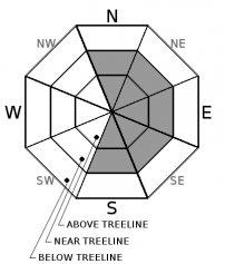
Bottom Line
The avalanche danger is LOW below treeline and MODERATE near and above treeline. The wind slab avalanche problem remains a concern due to strong winds expected near and above treeline on Mount Shasta. Human triggered avalanches are possible in steep, freshly wind loaded terrain on NE-E-SE facing aspects. Rime ice is plastered to exposed rocks. Wear a helmet.


Avalanche Problem 1: Wind Slab
-
Character ?

-
Aspect/Elevation ?
-
Likelihood ?CertainVery LikelyLikelyPossible
 Unlikely
 -
Size ?HistoricVery LargeLargeSmall

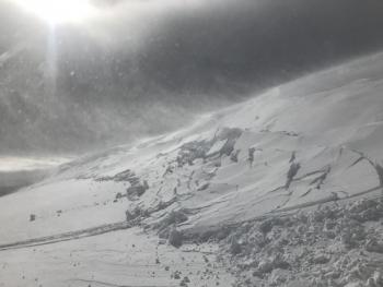
Wind slabs remain a concern, especially with a round of wind expected for today. Near and above treeline, west/northwest winds will move snow onto leeward NE-E-SE slopes and cross-load some more northerly and southerly slopes. High winds will deposit snow further down leeward slopes than usual, so expect mid-slope starting zones (steep roll-overs, convexities) to be potentially senstive. New wind slabs may build on top of existing wind slabs. Avalanches could be stubborn to touchy to trigger and could be large enough to bury or injure a skier or rider. Look for clues such as cornice formations, wind pillows, and stiff surface snow to help identify and avoid areas of potentially unstable wind slab.
Forecast Discussion
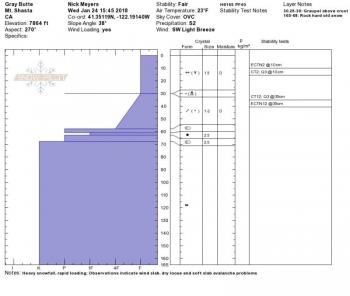
New, low density snow continues to settle out and warming temperatures will aid with that today. Signs of instability have been minimal aside from the one natural wind slab off Green Butte from a few days ago. Some uncertainly lies regarding warming temperatures and high winds today (new, dense wind slabs over recent low density snow). Continue to play it safe. Pay attention to wind loading. Lastly, warming temperatures will cause rime ice to plummet down onto skiers and climbers below.
Recent Observations
- No new snow in past 24 hours
- Temperatures trend warming today
- 1-2 inches of settlement in storm snow
- Yesterday was the first day of good visibility above treeline, mainly for first half of the day, then high clouds and flat light for the afternoon
- Above 7,500 feet, a uniform distribution of new snow averaged 30-40 cm / exposed areas 15-20 cm / drifts 80-90 cm
- Above treeline terrain remarkably smooth with little wind affect
- Winds were light to moderate out of the west/northwest. Blowing snow was visible off ridgelines above 9,000 ft.
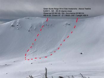
- One, recent natural wind slab avalanche (see observation) was observed off the NE aspect of Green Butte, HS-N-D2. This avalanche is estimated to have occurred on 1.24.18
- Many rocks lurk just beneath soft snow surface
- Rime ice plastered to all exposed rock features on upper mountain

Weather and Current Conditions
Weather Summary
Low pressure drives northwesterly over the area today. Mount Shasta remains on the southern edge of any associated precipitation. While the Cascades and coastal areas of Oregon have received a decent soaking, Northern California has experienced little to nothing. Expect lingering snow showers this morning on the mountain. Temperatures will rise and a slight chance of light rain is possible this afternoon. Most likely, we'll see gradual clearing and windy conditions above treeline. Tomorrow will be sunny.
24 Hour Weather Station Data @ 4:00 AM
| Weather Station | Temp (°F) | Wind (mi/hr) | Snow (in) | Comments | ||||||||
|---|---|---|---|---|---|---|---|---|---|---|---|---|
| Cur | Min | Max | Avg | Avg | Max Gust | Dir | Depth | New | Water Equivalent | Settlement | ||
| Mt. Shasta City (3540 ft) | 30 | 28 | 35 | 32 | 2 | N | ||||||
| Sand Flat (6750 ft) | 22 | 12 | 25 | 19 | 27 | 0 | 0 | 1 | ||||
| Ski Bowl (7600 ft) | 19 | 11 | 20 | 17 | 48 | 0 | .01 | 1 | ||||
| Gray Butte (8000 ft) | 18 | 13 | 22 | 17 | 11 | 25 | WNW | |||||
| Castle Lake (5870 ft) | 23 | 19 | 32 | 24 | 14 | 0 | 2 | |||||
| Mount Eddy (6509 ft) | 21 | 12 | 24 | 20 | 1 | 8 | SE | 30 | 0 | 0 | ||
| Ash Creek Bowl (7250 ft) | station down | |||||||||||
| Ash Creek Ridge (7895 ft) | station down |
Two Day Mountain Weather Forecast
Produced in partnership with the Medford NWS
| For 7000 ft to 9000 ft | |||
|---|---|---|---|
|
Saturday (4 a.m. to 10 p.m.) |
Saturday Night (10 p.m. to 4 a.m.) |
Sunday (4 a.m. to 10 p.m.) |
|
| Weather | Cloudy, breezy, snow likely this morning, then chance of rain and snow this afternoon. Snow levels near town this morning, rising to 6,000 ft | Mostly cloudy | Not as cool, partly cloudy in the morning, then clearing |
| Temperature (°F) | 36 | 29 | 46 |
| Wind (mi/hr) | South 10-15 mph | West 5-10 mph | Northeast 0-5 mph |
| Precipitation SWE / Snowfall (in) | / 1 | / 0 | / 0 |
| For 9000 ft to 11000 ft | |||
| Saturday | Saturday Night | Sunday | |
| Weather | Snow, mainly before 10am. Windy | Mostly cloudy, windy | Mostly sunny |
| Temperature (°F) | 25 | 25 | 32 |
| Wind (mi/hr) | Southwest 35-45 mph with gusts higher | Southwest 1-2 | Southwest 10-15 mph |
| Precipitation SWE / Snowfall (in) | / 1-2 | / 0 | / 0 |
Season Precipitation for Mount Shasta City
| Period | Measured (in) | Normal (in) | Percent of Normal (%) |
|---|---|---|---|
| From Oct 1, 2025 (the wet season) | 10.11 | 21.22 | 48 |
| Month to Date (since Jun 1, 2026) | 4.28 | 6.01 | 71 |
| Year to Date (since Jan 1, 2026) | 4.28 | 6.01 | 71 |

