

You are here
Avalanche Forecast for 2018-12-27 06:26
- EXPIRED ON December 28, 2018 @ 6:26 amPublished on December 27, 2018 @ 6:26 am
- Issued by Nick Meyers - Shasta-Trinity National Forest
Bottom Line
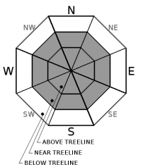
MODERATE avalanche danger exists near and above treeline as continued high winds affect the mountain through Friday. Wind slab avalanches are possible. LOW avalanche danger will exist below treeline.


Avalanche Problem 1: Wind Slab
-
Character ?

-
Aspect/Elevation ?
-
Likelihood ?CertainVery LikelyLikelyPossible
 Unlikely
 -
Size ?HistoricVery LargeLargeSmall

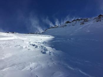
Strong northerly wind will continue to redistribute snow and scour other areas down to old, firm snow surfaces. During high wind events such as we are seeing now, much of the snow will either blow off the mountain or deposit into gullies and onto low angle terrain. Regardless, blowing snow is a red flag for avalanche danger. Even though snow is not falling from the sky, avalanches are possible if you observe wind blowing snow. Look for wind slabs on the lee side of ridges in terrain steeper than 35 degrees. Wind slabs are often smooth and round and sometimes sound hollow.
Exercise caution near slopes greater than 35 degrees and be looking for signs of the wind slab problem:
- Blowing snow
- Cornices
- Wind pillows
- Shooting cracks
- Hollow sounding snow
Forecast Discussion
Our familiar friend, the wind... If you have not been introduced, take a tour today for a meet and greet. Triggering an old wind slab today will be difficult, one of those low probability, high consequence type of events. New wind slabs are possible and could be easier to kick off. Any avalance will be isolated. Most of the near and above treeline terrain is scoured to old snow surfaces. Expect brief moments of brilliance followed by fight or flight if sliding around today.
Recent Observations
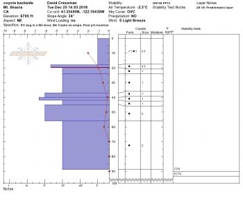
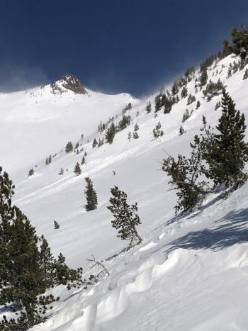
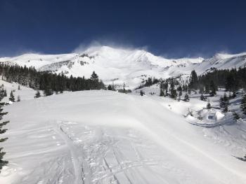
High temperature yesterday was 39 degrees F during the late AM hours. Dripping trees were observed around Bunny Flat. Near and above treeline was a bit more wind effected than the day prior. One will notice many interesting loading patterns across Mount Shasta's terrain. Some wind loaded areas look like avalanche crown lines, though are likely striping/loading of snow. Large, thick and hard wind slabs dot the landscape above treeline on the mountain. These slabs have been difficult to trigger. Most classic avalanche starting zones have been stripped of the foot of new snow received this past week. Needless to say, snow surfaces have been pounded by northerly winds and certainly look like it. Since 11 AM yesterday, northwesterlies have averaged 18 mi/hr with gusts to 55 mi/hr. These winds are in addition to the windy conditions of several days past. After yesterday's warming, a sun crust is possible at lower elevations today. A couple of small D1 wind slab avalanches were observed in Giddy Giddy Gulch, Avalanche Gulch and above Hidden Valley two days ago, but nothing since.
Weather and Current Conditions
Weather Summary
For the big picture, our weather will begin to enter a relatively dry phase as compared to earlier in the week with no headlining precipitation events on the horizon. One can expect fog and freezing fog in the valleys, a few high clouds and blue sky for the near future. Today through Friday will be windy as strong northwest winds move over the upper mountain. As always, we eagerly await more winter weather. A system is poised to reach the area late next week.
24 Hour Weather Station Data @ 5:00 AM
| Weather Station | Temp (°F) | Wind (mi/hr) | Snow (in) | Comments | ||||||||
|---|---|---|---|---|---|---|---|---|---|---|---|---|
| Cur | Min | Max | Avg | Avg | Max Gust | Dir | Depth | New | Water Equivalent | Settlement | ||
| Mt. Shasta City (3540 ft) | 25 | 24 | 41 | 33.5 | 4 | N | ||||||
| Sand Flat (6750 ft) | 21 | 20 | 36 | 28 | 41 | 0 | 0 | 1 | ||||
| Ski Bowl (7600 ft) | 19.5 | 19.5 | 39.5 | 28.5 | 51.2 | 0 | 0 | 1 | ||||
| Gray Butte (8000 ft) | 21.5 | 18 | 35 | 26.5 | 18 | 55 | NW | |||||
| Castle Lake (5870 ft) | station down | |||||||||||
| Mount Eddy (6509 ft) | 19.5 | 19.5 | 37 | 27.5 | 3 | 18 | ESE | 43 | 0 | .5 | ||
| Ash Creek Bowl (7250 ft) | station down | |||||||||||
| Ash Creek Ridge (7895 ft) | station down |
Two Day Mountain Weather Forecast
Produced in partnership with the Medford NWS
| For 7000 ft to 9000 ft | |||
|---|---|---|---|
|
Thursday (4 a.m. to 10 p.m.) |
Thursday Night (10 p.m. to 4 a.m.) |
Friday (4 a.m. to 10 p.m.) |
|
| Weather | Mostly sunny, blustery | Mostly clear, blustery | Mostly sunny |
| Temperature (°F) | 22 | 19 | 32 |
| Wind (mi/hr) | North 10-15 | North 10-15 | North 5-10 |
| Precipitation SWE / Snowfall (in) | / 0 | / 0 | / 0 |
| For 9000 ft to 11000 ft | |||
| Thursday | Thursday Night | Friday | |
| Weather | Mostly sunny, windy. | Partly cloudy, windy. | Mostly sunny |
| Temperature (°F) | 13 | 13 | 23 |
| Wind (mi/hr) | North 40-50 | North 0 | North 30-40 |
| Precipitation SWE / Snowfall (in) | / 0 | / 0 | / 0 |
Season Precipitation for Mount Shasta City
| Period | Measured (in) | Normal (in) | Percent of Normal (%) |
|---|---|---|---|
| From Oct 1, 2025 (the wet season) | 8.39 | 13.93 | 60 |
| Month to Date (since Jun 1, 2026) | 3.66 | 6.57 | 56 |
| Year to Date (since Jan 1, 2026) | 23.67 | 41.93 | 56 |

