

You are here
Avalanche Forecast for 2019-01-02 05:32
- EXPIRED ON January 3, 2019 @ 5:32 amPublished on January 2, 2019 @ 5:32 am
- Issued by Ryan Sorenson - Mount Shasta Avalanche Center
Bottom Line
Avalanche danger is LOW at all elevations. Natural and human triggered avalanches are unlikely. While unlikely, lingering wind slabs could remain in isolated, leeward terrain. Normal caution is advised. Challenging surface textures and slide for life conditions remain a concern near and above treeline today. Icy slopes present dangerous climbing conditions.


Avalanche Problem 1: Normal Caution
-
Character ?

-
Aspect/Elevation ?
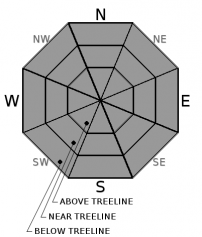
-
Likelihood ?CertainVery LikelyLikelyPossible
 Unlikely
Exercise normal caution when traveling in the backcountry. This means:
- Always watch for isolated slabs on leeward terrain.
- Continue to carry rescue gear and know how to use it. Essential rescue gear includes: avalanche beacon, shovel, and probe.
- Ice axe, crampons, and helmet are needed if climbing into the upper regions of the mountain.
- Rock and ice fall presents hazards in areas below exposed ridge lines and cliffs. Limit time spent in steep runout zones.
Forecast Discussion
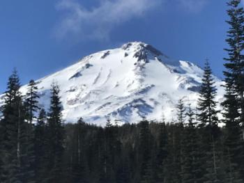
Climbers beware; scoured icy slopes present slide for life conditions. An ice axe, crampons, and helmet are mandatory tools if attempting a summit of Mount Shasta. Self-arrest will be difficult if not impossible.
Rime and ice incrust rock in the upper mountain. Always be aware of potential rock and ice fall in runout zones if climbing or skiing upper portions of the mountain. Warming temperatures this afternoon could increase the chance of rock and ice fall.
Recent Observations
The temperature maxed out at 39 degrees at 8,000 feet yesterday afternoon. Nightly low temperatures have hovered around 32 degrees. Breezy northeast wind 20-30 mi/hr blew for 5 hours yesterday morning. This wind give way to calmer, more westly wind after 1 p.m..
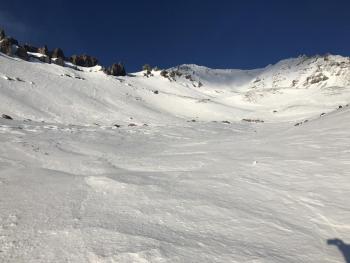
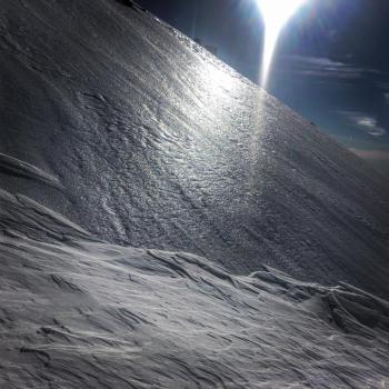
A tour up Avalanche Gulch found scoured ridge tops and variable, textured snow remaining near and above treeline. Strong wind this December has transformed and sculpted any snow available for transport. Surface textures range from sastrugi to chalky wind board in protected lower lying gullies. Scattered rocks and a thick layer of ice encrusts ridge tops and windward faces near and above treeline. Variable conditions with spotty breakable melt freeze crust and pockets of softer snow can be found below treeline.
No signs of instabilities have been observed. Overall snow surfaces are challenging: bulletproof ice, breakable crusts, sastrugis, scoured ridge lines, and chalky gullies.

Weather and Current Conditions
Weather Summary
Our current high pressure weather condition is expected to persist until an area of low pressure moves in this weekend. Low clouds and fog will quickly burn off to sunny and somewhat warmer temperatures this afternoon. Temperatures are anticipated to climb to the mid 40s across the region today. Northerly wind is expected to stay relatively calm below and near treeline. Breezy above treeline wind nearing 20 to 25 mi/hr will likely calm down in the afternoon.
24 Hour Weather Station Data @ 2:00 AM
| Weather Station | Temp (°F) | Wind (mi/hr) | Snow (in) | Comments | ||||||||
|---|---|---|---|---|---|---|---|---|---|---|---|---|
| Cur | Min | Max | Avg | Avg | Max Gust | Dir | Depth | New | Water Equivalent | Settlement | ||
| Mt. Shasta City (3540 ft) | 22 | 20 | 39 | 28.5 | 2 | N | ||||||
| Sand Flat (6750 ft) | 24 | 9 | 35 | 24 | 39 | 0 | 0 | 0 | ||||
| Ski Bowl (7600 ft) | 30.5 | 15.5 | 44.5 | 33.5 | 41 | 0 | 0 | 0 | ||||
| Gray Butte (8000 ft) | 30.5 | 16.5 | 39.5 | 33.5 | 7 | 49 | NNE | |||||
| Castle Lake (5870 ft) | station down | |||||||||||
| Mount Eddy (6509 ft) | 32 | 25.5 | 39.5 | 34 | 2 | 14 | SW | 38 | 0 | 0 | ||
| Ash Creek Bowl (7250 ft) | station down | |||||||||||
| Ash Creek Ridge (7895 ft) | station down |
Two Day Mountain Weather Forecast
Produced in partnership with the Medford NWS
| For 7000 ft to 9000 ft | |||
|---|---|---|---|
|
Wednesday (4 a.m. to 10 p.m.) |
Wednesday Night (10 p.m. to 4 a.m.) |
Thursday (4 a.m. to 10 p.m.) |
|
| Weather | Sunny | Party cloudy | Partly cloudy then mostly cloudy |
| Temperature (°F) | 40 | 28 | 40 |
| Wind (mi/hr) | Northeast 5-10 | Southwest 0-5 | South 5-10 |
| Precipitation SWE / Snowfall (in) | / 0 | / 0 | / 0 |
| For 9000 ft to 11000 ft | |||
| Wednesday | Wednesday Night | Thursday | |
| Weather | Sunny | Partly cloudy | Partly cloudy then mostly cloudy |
| Temperature (°F) | 35 | 30 | 30 |
| Wind (mi/hr) | North 15-20 | West 0 | West 25-30 |
| Precipitation SWE / Snowfall (in) | / 0 | / 0 | / 0 |
Season Precipitation for Mount Shasta City
| Period | Measured (in) | Normal (in) | Percent of Normal (%) |
|---|---|---|---|
| From Oct 1, 2025 (the wet season) | 8.41 | 15.45 | 54 |
| Month to Date (since Jun 1, 2026) | 0.00 | 0.24 | 0 |
| Year to Date (since Jan 1, 2026) | 0.00 | 0.24 | 0 |

