

You are here
Avalanche Forecast for 2019-01-05 06:21
- EXPIRED ON January 6, 2019 @ 6:21 amPublished on January 5, 2019 @ 6:21 am
- Issued by Nick Meyers - Shasta-Trinity National Forest
Bottom Line
Strong southerly wind and copius amounts of new snow will contribute to wind and storm slab avalanche problems this weekend. LOW avalanche danger this morning will increase significantly at all elevations following the onset of new snowfall today. Expect MODERATE danger below treeline and MODERATE to CONSIDERABLE danger near and above treeline by late this afternoon/evening.


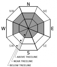
Avalanche Problem 1: Wind Slab
-
Character ?

-
Aspect/Elevation ?
-
Likelihood ?CertainVery LikelyLikelyPossible
 Unlikely
 -
Size ?HistoricVery LargeLargeSmall

Strong wind will drift new snow into firm, thick slabs this weekend. As you go higher in elevation, wind slabs could become larger and easier to trigger. You can use visual clues to identify and avoid wind loaded slopes over 35 degrees. Fresh cornices, blowing snow, snow drifts, and uneven snow surfaces are all signs that wind slabs are in nearby terrain.
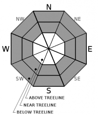
Avalanche Problem 2: Storm Slab
-
Character ?

-
Aspect/Elevation ?
-
Likelihood ?CertainVery LikelyLikelyPossible
Unlikely
-
Size ?HistoricVery LargeLargeSmall
If you find yourself in the backcountry late this afternoon and see more than 8 inches of new storm snow accumulated, you may encounter storm slabs. Stay away from convex rollovers, unsupported slopes, and slopes over 40 degrees where you could trigger storm snow. This problem will be confined to more protected, below and near treeline areas.
Forecast Discussion
Hurricane force winds and blizzard conditions are expected above treeline through the weekend. A winter storm warning is in effect from 11am this morning to 10pm PST Sunday, above 3,000 feet. Be safe out there. Carry proper companion rescue gear, communicate within your group a plan for managing avalanche terrain, and expose only one person at a time to avalanche terrain.
Recent Observations
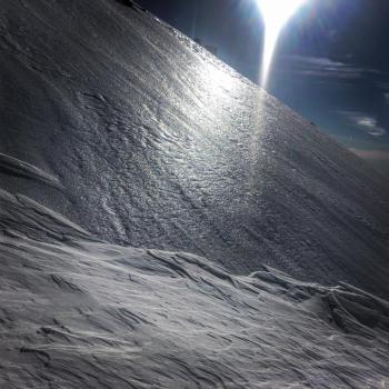
- Strong winds and warming events over the past week have left behind variable snow surface conditions including firm wind packed, firm wind scoured, exposed ice, melt freeze crust, and pockets of soft unconsolidated snow. These different conditions exist in close proximity to one another. Uncertainity remains on how well the new snow will bond to the these old snow surfaces.
- Weak facets and thin crusts found in below and near treeline northerly areas indicate questionable ability for the upper snowpack layers to support new snow loading.

Weather and Current Conditions
Weather Summary
The first band of showers that will commence the weekend weather is moving onshore at this time. Strong southerly flow up the Sacramento Valley drainage will transport high moisture flow as well as provide good orographic lift to the Mount Shasta area. Snow levels may drop down to 2,500 feet during periods of high intensity precipitation. Winds will increase by late afternoon as the low moves onshore. We will see a brief lull in heavier snow on Sunday morning. South winds will increase again and heavy precip rates will return late morning and into the afternoon. Upwards of 2.33 inches of water is expected by Monday morning. This will mean multiple feet of new snow in higher terrain.
24 Hour Weather Station Data @ 4:00 AM
| Weather Station | Temp (°F) | Wind (mi/hr) | Snow (in) | Comments | ||||||||
|---|---|---|---|---|---|---|---|---|---|---|---|---|
| Cur | Min | Max | Avg | Avg | Max Gust | Dir | Depth | New | Water Equivalent | Settlement | ||
| Mt. Shasta City (3540 ft) | 37 | 32 | 48 | 41 | 3 | N | ||||||
| Sand Flat (6750 ft) | 27 | 27 | 37 | 31 | 38 | 0 | 0 | 1 | ||||
| Ski Bowl (7600 ft) | 23 | 23 | 31.5 | 27 | 41 | 0 | 0 | 0 | ||||
| Gray Butte (8000 ft) | 21 | 21 | 31 | 25 | 10 | 31 | SSE | |||||
| Castle Lake (5870 ft) | station down | |||||||||||
| Mount Eddy (6509 ft) | 26 | 25.5 | 36.5 | 29.5 | 2 | 12 | SSW | 37 | 0 | 1 | ||
| Ash Creek Bowl (7250 ft) | station down | |||||||||||
| Ash Creek Ridge (7895 ft) | station down |
Two Day Mountain Weather Forecast
Produced in partnership with the Medford NWS
| For 7000 ft to 9000 ft | |||
|---|---|---|---|
|
Saturday (4 a.m. to 10 p.m.) |
Saturday Night (10 p.m. to 4 a.m.) |
Sunday (4 a.m. to 10 p.m.) |
|
| Weather | Snow, heavy at times, windy. | Snow, heavy at times; windy. | Snow, heavy at times, breezy. |
| Temperature (°F) | 29 | 21 | 28 |
| Wind (mi/hr) | South 25-30 | Southwest 20-25 | South 15-20 |
| Precipitation SWE / Snowfall (in) | / 5-11 / SWE: .96" | / 4-9 / SWE: .49" | / 16-20 / SWE: .89" |
| For 9000 ft to 11000 ft | |||
| Saturday | Saturday Night | Sunday | |
| Weather | Snow, heavy at times, very windy | Snow, heavy at times, very windy. | Snow, heavy at times, very windy |
| Temperature (°F) | 22 and falling | 7 | 13 |
| Wind (mi/hr) | South 60-70 | Southwest 10-16 | Southwest 40-50 |
| Precipitation SWE / Snowfall (in) | / 10-16 | / 7-11 | / 20-26 |
Season Precipitation for Mount Shasta City
| Period | Measured (in) | Normal (in) | Percent of Normal (%) |
|---|---|---|---|
| From Oct 1, 2025 (the wet season) | 8.41 | 16.15 | 52 |
| Month to Date (since Jun 1, 2026) | 0.00 | 0.94 | 0 |
| Year to Date (since Jan 1, 2026) | 0.00 | 0.94 | 0 |

