

You are here
Avalanche Forecast for 2019-01-06 06:00
- EXPIRED ON January 7, 2019 @ 6:00 amPublished on January 6, 2019 @ 6:00 am
- Issued by Aaron Beverly - Mount Shasta Avalanche Center
Bottom Line
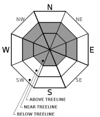
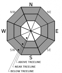
Avalanche danger will be CONSIDERABLE near and above treeline. Thick wind slabs have formed on leeward aspects and will continue to increase in size with over a foot of new snow expected. Stick to low angle slopes and be wary of what terrain is above you. Strong to gale force winds will keep conditions unbearable in the alpine regions. Continue to watch out for storm slabs in wind protected areas. Avalanche danger is MODERATE below treeline.


Avalanche Problem 1: Wind Slab
-
Character ?

-
Aspect/Elevation ?
-
Likelihood ?CertainVery LikelyLikelyPossible
 Unlikely
 -
Size ?HistoricVery LargeLargeSmall

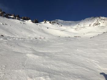
Wind slabs will be the primary concern today. Moderate winds blew from the south throughout yesterday's storm. Inches of new snow today coupled with strong southerly winds will increase the size of slabs. These slabs are likely sit atop icy surfaces and crusts making them touchy to trigger. Look for them everywhere, but expect them on west, east, and north aspects.
Avoid wind loaded slopes over 35 degrees. Look for visual clues. Fresh cornices, blowing snow, snow drifts, and uneven snow surfaces are all signs that wind slabs are in nearby terrain.
Avalanche Problem 2: Storm Slab
-
Character ?

-
Aspect/Elevation ?
-
Likelihood ?CertainVery LikelyLikelyPossible
Unlikely
-
Size ?HistoricVery LargeLargeSmall
Storm Slabs form when new snow consolidates over a weaker layer or interface. Cold temperatures and a right side up snow pack configuration may keep this problem at bay, but with over a foot of new snow expected today, continue to be wary of this issue.
Stay away from convex rollovers, unsupported slopes, and slopes over 40 degrees. This problem will be confined to protected areas below and near treeline.
Forecast Discussion
There is uncertainty in wind forecasts on Mount Shasta, but confidence seems high that we'll see strong to gale force winds today above treeline. It'll be best to avoid going high, but if you do, bundle up and hang on. Expect winds to chill to the bone.
If you venture out, keep in mind the 5 obvious signs of avalanche danger:
- Recent avalanche activity
- Cracking, blocking, or whoomphing
- Significant snowfall in 24 hours *
- Strong winds *
- Rapid warming
* - this has happened, and will happen today.
Recent Observations
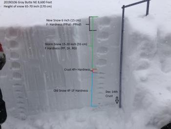
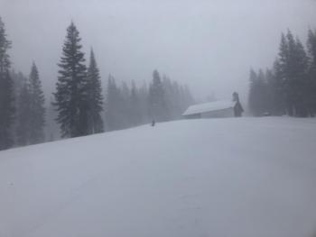
Over 10 inches of dry snow was received over the last 24 hours at the Old Ski Bowl. Temperatures trended from high to low, but generally remained in the low 20s. Moderate southerly winds blew throughout the bulk of yesterday's storm. Gusts reached 47 mi/hr.
Skiers reported dust on crust to 5-6 inches in wind protected areas. Some cracking was observed on rollovers without much propagation. Low visibility kept observations limited to near and below treeline.
Surface hoar was still being encountered on northerly aspects two days ago.
Weather and Current Conditions
Weather Summary
A winter storm warning is in effect from 10 a.m. to 10 p.m. Snow levels will hover around 3000 feet, but heavy snow may drag those down to Dunsmuir at times.
Cold temperatures and over an inch of precipitable water should bring well over a foot of snow today and tonight.
Steep pressure gradients could produce strong to gale force winds from the south above treeline.
Wet weather is expected to persist for the next 10 days.
24 Hour Weather Station Data @ 3:00 AM
| Weather Station | Temp (°F) | Wind (mi/hr) | Snow (in) | Comments | ||||||||
|---|---|---|---|---|---|---|---|---|---|---|---|---|
| Cur | Min | Max | Avg | Avg | Max Gust | Dir | Depth | New | Water Equivalent | Settlement | ||
| Mt. Shasta City (3540 ft) | 31 | 30 | 38 | 33 | 3 | N | ||||||
| Sand Flat (6750 ft) | 21 | 21 | 27 | 25 | 47 | 10 | 1 | 1 | ||||
| Ski Bowl (7600 ft) | 17 | 17 | 23.5 | 20.5 | 52.7 | 11 | 1.2 | 1 | ||||
| Gray Butte (8000 ft) | 16 | 16 | 21 | 19.5 | 16 | 49 | SSE | |||||
| Castle Lake (5870 ft) | station down | |||||||||||
| Mount Eddy (6509 ft) | 20 | 19.5 | 26 | 23.5 | 3 | 19 | SSE | 49.9 | 11 | 1 | ||
| Ash Creek Bowl (7250 ft) | station down | |||||||||||
| Ash Creek Ridge (7895 ft) | station down |
Two Day Mountain Weather Forecast
Produced in partnership with the Medford NWS
| For 7000 ft to 9000 ft | |||
|---|---|---|---|
|
Sunday (4 a.m. to 10 p.m.) |
Sunday Night (10 p.m. to 4 a.m.) |
Monday (4 a.m. to 10 p.m.) |
|
| Weather | Snow showers before 10 a.m., then snow after 10 a.m. The snow could be heavy at times. Windy. Chance of precipitation is 100%. | Snow before 10 p.m., then snow showers, mainly after 10 p.m. The snow could be heavy at times. Breezy and gusty. Chance of precipitation is 100%. | Snow showers likely, mainly before 10 a.m., then snow likely after 4 p.m. Mostly cloudy. Chance of precipitation is 60%. |
| Temperature (°F) | 27 | 25 | 32 |
| Wind (mi/hr) | South 20-25 | South 15-20 | South 10-15 |
| Precipitation SWE / Snowfall (in) | / 5-8 | / 2-4 | / 1 |
| For 9000 ft to 11000 ft | |||
| Sunday | Sunday Night | Monday | |
| Weather | Snow showers before 10 a.m., then snow after 10 a.m. The snow could be heavy at times. Windy and gusty. Below zero wind chills. Chance of precipitation is 100%. | Snow before 10 p.m., then snow showers, mainly after 10 p.m. The snow could be heavy at times. Windy and gusty. Below zero wind chills. Chance of precipitation is 100%. | Snow showers likely, mainly before 10 a.m., then snow likely after 4 p.m. Mostly cloudy. Windy and gusty. Below zero wind chills. Chance of precipitation is 60%. |
| Temperature (°F) | 16 | 13 | 25 |
| Wind (mi/hr) | Southwest 40-50 | Southwest 13-17 | West 35-40 |
| Precipitation SWE / Snowfall (in) | / 13-17 | / 5-8 | / 1-2 |
Season Precipitation for Mount Shasta City
| Period | Measured (in) | Normal (in) | Percent of Normal (%) |
|---|---|---|---|
| From Oct 1, 2025 (the wet season) | 9.28 | 16.38 | 57 |
| Month to Date (since Jun 1, 2026) | 0.87 | 1.17 | 74 |
| Year to Date (since Jan 1, 2026) | 0.87 | 1.17 | 74 |

