

You are here
Avalanche Forecast for 2019-02-17 06:00
- EXPIRED ON February 18, 2019 @ 6:00 amPublished on February 17, 2019 @ 6:00 am
- Issued by Aaron Beverly - Mount Shasta Avalanche Center
Bottom Line
Wind slabs and cornice failures remain a concern near and above treeline. Shooting cracks and wind slab releases were triggered on small test slopes yesterday. Wind slab avalanches could be very large so continue to choose conservative terrain for a while longer. Cold weather will delay the settlement and consolidation of the snowpack.


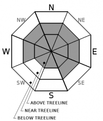
Avalanche Problem 1: Wind Slab
-
Character ?

-
Aspect/Elevation ?
-
Likelihood ?CertainVery LikelyLikelyPossible
 Unlikely
 -
Size ?HistoricVery LargeLargeSmall

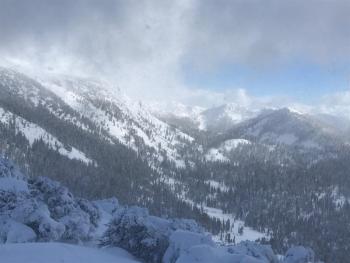
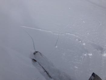
Shooting cracks and wind slab releases on small test slopes yesterday indicate the wind slab problem remains. Slabs could be very thick and avalanches triggered could be very large. Easterly facing aspects held the most snow, but productive winds have been blowing since February 13th from a variety of directions. As the skies begin to clear over the next few days, it will be important to approach near and above treeline avalanche terrain with caution.
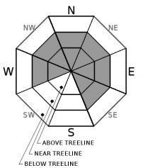
Avalanche Problem 2: Cornice
-
Character ?

-
Aspect/Elevation ?
-
Likelihood ?CertainVery LikelyLikelyPossible
Unlikely
-
Size ?HistoricVery LargeLargeSmall
Cornice falls are caused when a mass of wind‐deposited snow, which is often overhanging and near a sharp terrain break such as a ridge, breaks off. Because they are so heavy, cornice falls often trigger avalanches on the slope below, compounding the problem for anyone in its path. Large and unstable cornices are still possible near and above treeline. Look for them overhanging primarily NE-E-SE facing slopes.
Forecast Discussion
Now that the storm cycle is over, natural avalanches are unlikely but not outside the realm of possibility as winds shift snow and weight around. Things felt sensitive out there yesterday above treeline so expect human-triggered avalanches to be possible.
Unusually cold weather may delay the settlement and consolidation of the snowpack, more so than we are used to. Give it some time to adjust. Be conservative in your route planning.
Recent Observations
Over the last 24 hours, the Old Ski Bowl has received 3 inches of snow. Temperatures ranged from 11 to 16 degrees and northwest winds ranged from 7 to 23 mi/hr.
Field observations still indicate a wind slab problem near and above treeline with plenty of shooting cracks and wind slab releases on small test slopes. These are mostly on easterly aspects. Northwest winds were continuing to transport snow yesterday afternoon.
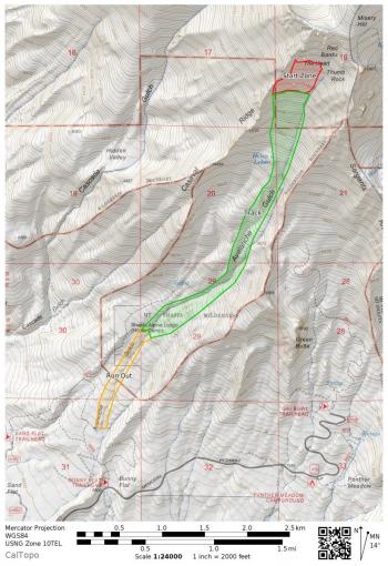
A very large (D4) avalanche was reported from Avalanche Gulch. The slide is estimated to have occurred on February 13th. Initial report indicates 30+ feet of debris, broken trees, and a terminus at 7,200 feet. This avalanche may have run serveral miles and thousands of vertical feet - a potentially historic avalanche.
Weather and Current Conditions
Weather Summary
Expect lingering snow showers without accumulation today and tonight. Northerly winds will be light to moderate. Temperatures may reach the single digits above treeline. Snow levels could drop as low as 500 ft.
We should see clearer conditions the next couple of days, though temperatures look to remain low throughout the week as a high pressure system helps move cold air down from the Gulf of Alaska. More unsettled weather is expected Wednesday.
24 Hour Weather Station Data @ 5:00 AM
| Weather Station | Temp (°F) | Wind (mi/hr) | Snow (in) | Comments | ||||||||
|---|---|---|---|---|---|---|---|---|---|---|---|---|
| Cur | Min | Max | Avg | Avg | Max Gust | Dir | Depth | New | Water Equivalent | Settlement | ||
| Mt. Shasta City (3540 ft) | 25 | 25 | 39 | 30.5 | 1 | N | ||||||
| Sand Flat (6750 ft) | 15 | 14 | 23 | 19 | 115 | 3 | 0 | 2 | ||||
| Ski Bowl (7600 ft) | 11 | 9.5 | 23 | 15 | 149.7 | 3 | 0.25 | 3 | ||||
| Gray Butte (8000 ft) | 10 | 9 | 21 | 13.5 | 13 | 37 | NW | |||||
| Castle Lake (5870 ft) | 16.5 | 15.5 | 36.5 | 22 | 98.1 | 2.6 | 4.3 | |||||
| Mount Eddy (6509 ft) | ||||||||||||
| Ash Creek Bowl (7250 ft) | ||||||||||||
| Ash Creek Ridge (7895 ft) |
Two Day Mountain Weather Forecast
Produced in partnership with the Medford NWS
| For 7000 ft to 9000 ft | |||
|---|---|---|---|
|
Sunday (4 a.m. to 10 p.m.) |
Sunday Night (10 p.m. to 4 a.m.) |
Monday (4 a.m. to 10 p.m.) |
|
| Weather | Snow showers likely, mainly before 10 a.m. Partly sunny. Chance of precipitation is 60%. | A 20 percent chance of snow showers before 10 p.m. Partly cloudy. | Mostly sunny. |
| Temperature (°F) | 24 | 11 | 23 |
| Wind (mi/hr) | Northwest 5-10 | North 10-15 | North 5-10 |
| Precipitation SWE / Snowfall (in) | / trace | / 0 | / 0 |
| For 9000 ft to 11000 ft | |||
| Sunday | Sunday Night | Monday | |
| Weather | Snow showers likely, mainly before 10 a.m. Partly sunny and cold, with a high near 1. Wind chill values as low as -15. Blustery. Chance of precipitation is 60%. | A 20 percent chance of snow showers before 10 p.m. Partly cloudy. Wind chill values as low as -17. Windy and gusty. | Mostly sunny. Wind chill values as low as -10. Windy and gusty. |
| Temperature (°F) | 5 | 5 | 12 |
| Wind (mi/hr) | North 15-20 | Northeast trace | North 25-30 |
| Precipitation SWE / Snowfall (in) | / trace | / 0 | / 0 |
Season Precipitation for Mount Shasta City
| Period | Measured (in) | Normal (in) | Percent of Normal (%) |
|---|---|---|---|
| From Oct 1, 2025 (the wet season) | 21.58 | 26.21 | 82 |
| Month to Date (since Jun 1, 2026) | 7.65 | 3.94 | 194 |
| Year to Date (since Jan 1, 2026) | 13.17 | 11.00 | 120 |

