

You are here
Avalanche Forecast for 2019-02-23 06:11
- EXPIRED ON February 24, 2019 @ 6:11 amPublished on February 23, 2019 @ 6:11 am
- Issued by Ryan Sorenson - Mount Shasta Avalanche Center
Bottom Line
Use caution today, increasing wind and new snow will increase avalanche risk. Be aware of isolated wind slabs in some terrain as well as icy ridgelines and falling rime ice at upper elevations. Fresh snow with west and south winds will increase throughout the weekend. Expect the avalanche danger to begin to rise today.


Avalanche Problem 1: Wind Slab
-
Character ?

-
Aspect/Elevation ?
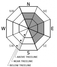
-
Likelihood ?CertainVery LikelyLikelyPossible
 Unlikely
 -
Size ?HistoricVery LargeLargeSmall

Use caution if navigating into the winter landscape today. Wind slabs on N-NE-E-SE leeward terrain are possible. Increasing moderate to strong west and south winds will continue to increase the risk of windslab formation for the next few days. New snow tonight will add more available snow for avalanche formation. Pay attention to where the wind is blowing and avoid loaded slopes. Previously scorn areas could become the ideal bed surface as the wind changes direction and increases with this incoming storm.
Old wind slabs and cornices along ridgelines have been difficult to trigger, but may still lurk in isolated areas. Unsupported slopes, gullies, couloirs, cliffy areas and other complex or extreme terrain represent the best places to find a lingering wind slab.
If travelling in avalanche terrain today have a plan and stick to these travel techniques:
- Ski and ride one at a time. Limit the number exposed to a potential avalanche.
- Don't regroup in avalanche paths or in run out zones. Stay out of harm's way.
- Identify areas of concern and avoid them if necessary.
- Don't expose other to risk.
- Carry rescue equipment (beacon, shovel and probe) and know how to use them. Practice!
Forecast Discussion
The NOAA forecast discussion this morning is talking of "a very active wet pattern with rising snow levels, and very high snow amounts at higher elevations". Click here if you would like to read more.
Recent Observations
Yesterday saw temperatures in the mid-20s and mostly sunny conditions. This clear day before the storm has done little to change the snowpack.
Notable recent observations:
- The wind has shifted to out of the north-west on Gray Butte last night
- Moderate wind with gusts as high as 37 was recorded last night at 8,000 feet on Mount Shasta.
- Variable snow surfaces: firm and scoured, wind packed powder, dust on crust, soft powder in protected areas
- No signs of slab instabilities
Weather and Current Conditions
Weather Summary
For those of you planning today's footwear right now, flip flops may be a bold move. Cold temperatures will remain with a chance of snow this evening. Snow levels will start low at 3,000 feet today and increase through Sunday. A large amount of snow is headed our way over the next week.
For today, expect increasing clouds in the afternoon. Light to moderate wind switching to the south will be below and near treeline. Moderate to strong Southwest wind will blow above treeline.
Little accumulation of snow will fall today. We will see 2-4 inches of new snow by tomorrow morning. Increasing totals of snowfall will continue for the next few days.
24 Hour Weather Station Data @ 6:00 AM
| Weather Station | Temp (°F) | Wind (mi/hr) | Snow (in) | Comments | ||||||||
|---|---|---|---|---|---|---|---|---|---|---|---|---|
| Cur | Min | Max | Avg | Avg | Max Gust | Dir | Depth | New | Water Equivalent | Settlement | ||
| Mt. Shasta City (3540 ft) | 30 | 12 | 41 | 29.5 | 1 | N | ||||||
| Sand Flat (6750 ft) | 10 | 5 | 22 | 13 | 111 | 0 | 0 | 0 | ||||
| Ski Bowl (7600 ft) | 16.5 | 8.5 | 29.5 | 20.5 | 136 | 0 | 0 | 0 | ||||
| Gray Butte (8000 ft) | 15 | 10.5 | 26 | 19 | 10 | 37 | WNW | |||||
| Castle Lake (5870 ft) | 24 | 9.5 | 34.5 | 24 | 95.5 | 0 | 0 | |||||
| Mount Eddy (6509 ft) | ||||||||||||
| Ash Creek Bowl (7250 ft) | station down | |||||||||||
| Ash Creek Ridge (7895 ft) | station down |
Two Day Mountain Weather Forecast
Produced in partnership with the Medford NWS
| For 7000 ft to 9000 ft | |||
|---|---|---|---|
|
Saturday (4 a.m. to 10 p.m.) |
Saturday Night (10 p.m. to 4 a.m.) |
Sunday (4 a.m. to 10 p.m.) |
|
| Weather | Partly cloudy, increasing clouds, chance of snow | Cloudy. Snow showers. Chance of snow 90 percent. | Snow, mostly cloudy. Increasing snow and wind. |
| Temperature (°F) | 25 | 20 | 30 |
| Wind (mi/hr) | Southwest 5-10 | South 5-10 | South 5-10 |
| Precipitation SWE / Snowfall (in) | / 0-1 | / 2-4 | / 3-6 |
| For 9000 ft to 11000 ft | |||
| Saturday | Saturday Night | Sunday | |
| Weather | Partly cloudy, increasing clouds, chance of snow | Partly cloudy, increasing clouds and snow, windy | Snow, mostly cloudy, increasing snow fall and breezy conditions |
| Temperature (°F) | 15 | 15 | 30 |
| Wind (mi/hr) | West 20-30 | West 0-1 | West 35-40 |
| Precipitation SWE / Snowfall (in) | / 0-1 | / 2-4 | / 4-6 |
Season Precipitation for Mount Shasta City
| Period | Measured (in) | Normal (in) | Percent of Normal (%) |
|---|---|---|---|
| From Oct 1, 2025 (the wet season) | 21.81 | 27.87 | 78 |
| Month to Date (since Jun 1, 2026) | 7.88 | 5.60 | 141 |
| Year to Date (since Jan 1, 2026) | 13.40 | 12.66 | 106 |

