

You are here
Avalanche Forecast for 2019-03-19 07:00
- EXPIRED ON March 20, 2019 @ 7:00 amPublished on March 19, 2019 @ 7:00 am
- Issued by Aaron Beverly - Mount Shasta Avalanche Center
Bottom Line
Wet weather with above 6,000 feet snow levels returns tonight. A few inches of snow is expected. Though a rather large wet slab avalanche was observed above the road cut just below Bunny Flat yesterday afternoon, we feel this is an isolated event. Nonetheless, avoid steep slopes below treeline where you see roller balls or recent wet avalanches.


Avalanche Problem 1: Normal Caution
-
Character ?

-
Aspect/Elevation ?
Normal caution is advised. If traveling into steep terrain, have a plan, but be able to adjust to the conditions you find and the skills your group has. Bring the gear and skills necessary for avalanche rescue.
Wet avalanches, though unlikely, are a concern in isolated areas below treeline. If you see roller balls or pinwheels, it might be time to move to a different aspect.
Forecast Discussion
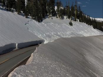
A wet slab avalanche occurred late in the afternoon yesterday. It was about 150 feet in length, had an 19 inch crown, and occurred above the road cut just below Bunny Flat.
Wet slab avalanches aren't seen much in these parts and are hard to predict. They are often foreshadowed by other wet slab or wet loose avalanches, periods of rapid warming, and channels in the upper layers of the snowpack that allow water to flow to weaker layers beneath. Aside from rapid warming, no other notable signs presented themselves before this occurrence.
We feel this is an isolated event. Similar events would be confined to the road going to Bunny Flat where there are small, steep unsupported slopes created by snow removal operations. Warm weather today may continue conditions capable of producing wet slab avalanches.
Castle Lake road is open.
Recent Observations
In the last three days, temperatures on Mount Shasta at 7,600 feet have ranged from near 30 to 49 degrees consistently, with lows only briefly dropping below freezing. The snowpack has lost about 7 inches. Easterly and southerly winds have been mostly light.
Although very few signs of wet avalanche instabilities have been seen, a rather large (D3) wet slab avalanche occurred on an unsupported slope above the road cut just below Bunny Flat parking lot. This was about 150 feet long, had a crown of 19 inches, and slid just above a crust layer.
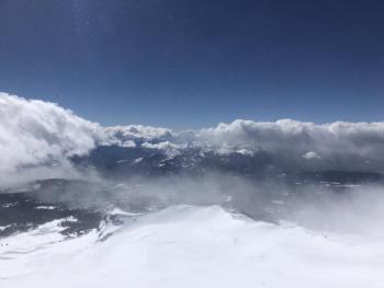
Snow surfaces above 10,000 feet have remained firm. Near treeline, surfaces are softening up after noon. Below treeline, snow has been heavy and wet. No signs of ice fall have been observed.


Weather and Current Conditions
Weather Summary
A low pressure trough off the coast will produce a southerly flow of warm, wet air tonight and tomorrow. Today expect cloudy weather as the warm front moves in.
Snow levels will start at 7,300 ft and drop to 6,200 feet by tomorrow. In the next 24 hours, 1-2 inches of snow could fall near and above treeline, which will combine with light to moderate southeast winds.
Tomorrow another 1-3 inches of snow is expected above 6,000 feet.
24 Hour Weather Station Data @ 5:00 AM
| Weather Station | Temp (°F) | Wind (mi/hr) | Snow (in) | Comments | ||||||||
|---|---|---|---|---|---|---|---|---|---|---|---|---|
| Cur | Min | Max | Avg | Avg | Max Gust | Dir | Depth | New | Water Equivalent | Settlement | ||
| Mt. Shasta City (3540 ft) | 40 | 29 | 66 | 47 | 1 | N | ||||||
| Sand Flat (6750 ft) | 39 | 29 | 53 | 40 | 133 | 0 | 0 | 3 | ||||
| Ski Bowl (7600 ft) | 37 | 31.5 | 45.5 | 38 | 167.1 | 0 | 0 | 3.2 | ||||
| Gray Butte (8000 ft) | 36 | 34 | 43 | 38 | 12 | 25 | SE | |||||
| Castle Lake (5870 ft) | not responding | |||||||||||
| Mount Eddy (6509 ft) | 38 | 31 | 47.5 | 41 | 2 | 10 | SW | 128.3 | 0 | 3 | ||
| Ash Creek Bowl (7250 ft) | ||||||||||||
| Ash Creek Ridge (7895 ft) |
Two Day Mountain Weather Forecast
Produced in partnership with the Medford NWS
| For 7000 ft to 9000 ft | |||
|---|---|---|---|
|
Tuesday (4 a.m. to 10 p.m.) |
Tuesday Night (10 p.m. to 4 a.m.) |
Wednesday (4 a.m. to 10 p.m.) |
|
| Weather | Partly sunny. | A chance of rain showers before 11 p.m., then rain and snow showers likely. Mostly cloudy. Chance of precipitation is 60%. | Rain and snow showers likely, becoming all snow after 11 a.m. Cloudy. Chance of precipitation is 70%. |
| Temperature (°F) | 57 | 32 | 33 |
| Wind (mi/hr) | Southeast 5-10 | Southeast 5-10 | South 5-10 |
| Precipitation SWE / Snowfall (in) | / 0 | / 1 | / 1-2 |
| For 9000 ft to 11000 ft | |||
| Tuesday | Tuesday Night | Wednesday | |
| Weather | Partly sunny. Windy. | Snow showers likely, mainly after 11 p.m. Cloudy. Windy. Chance of precipitation is 60%. | Snow showers likely. Cloudy. Windy. Chance of precipitation is 70%. |
| Temperature (°F) | 29 | 19 | 19 |
| Wind (mi/hr) | Southeast 25-30 | Southeast 0 | South 25-30 |
| Precipitation SWE / Snowfall (in) | / 0 | / `1-2 | / 1-3 |
Season Precipitation for Mount Shasta City
| Period | Measured (in) | Normal (in) | Percent of Normal (%) |
|---|---|---|---|
| From Oct 1, 2025 (the wet season) | 31.74 | 33.38 | 95 |
| Month to Date (since Jul 1, 2026) | 2.21 | 3.88 | 57 |
| Year to Date (since Jan 1, 2026) | 23.33 | 18.17 | 128 |

