

You are here
Avalanche Forecast for 2019-03-25 06:45
- EXPIRED ON March 26, 2019 @ 6:45 amPublished on March 25, 2019 @ 6:45 am
- Issued by Ryan Sorenson - Mount Shasta Avalanche Center
Bottom Line
Moderate avalanche danger exists due to fresh wind slabs forming near and above treeline this afternoon. Human triggered avalanches are possible in steep, leeward terrain.


Avalanche Problem 1: Wind Slab
-
Character ?

-
Aspect/Elevation ?
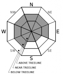
-
Likelihood ?CertainVery LikelyLikelyPossible
 Unlikely
 -
Size ?HistoricVery LargeLargeSmall

Wind slab avalanches will be possible this afternoon due to new snow and moderate to strong south winds. Snow showers will be heavy at times. Slab size is expected to grow large enough to bury a person in isolated steep leeward areas today.
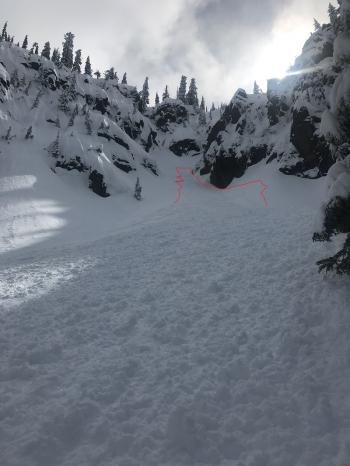
If travelling in the backcountry pay attention to where leeward areas reside. Evaluate snow and terrain carefully and identify features of concern. Stay away from steep slopes that have been loaded. Look for signs of wind slabs and cornices as you travel in safe terrain:
Shooting cracks, blocking, whumphing
Convex pillows of wind-drifted snow
Chalky, hollow sounding snow
Forecast Discussion
The national weather service has issued a winter storm warning remaining in effect until 5 p.m. this afternoon above 4000 feet.
Strong wind is expected in exposed terrain at higher elevations today. Below is a map graphically representing the winds on Mount Shasta. Darker colored lines represent stronger winds.

Recent Observations
Daylight hours yesterday hosted broken skies with low hanging clouds and periods of clearer skies poking through. Winds averaging 9 mi/hr with gusts to 31 out of the southeast was recorded on Mount Shasta. No blowing snow was visible on a tour near Castle Lake. An inch of light snow sat atop a supportable crust all above rounding precipitation particles from earlier in the storm. Variable surface textures included wind textured ridgelines, hard supportable crusts, soft rounding snow, and fresh new snow in protected pockets. See observation for more information.

Weather and Current Conditions
Weather Summary
A powerful winter storm has moved into the Mount Shasta area this morning. Heavy snow showers will bring 10-16 inches of snow over the next 24 hours. New snow could fall as low as 3,600 feet but little accumulation below 4,000 feet is expected. Light snow showers with snow levels around 4,000 feet will continue throughout the week. Strong south winds will be felt today. This storm will taper off tomorrow leaving a few lingering showers. Another front will bring more snow on Wednesday.
24 Hour Weather Station Data @ 6:00 AM
| Weather Station | Temp (°F) | Wind (mi/hr) | Snow (in) | Comments | ||||||||
|---|---|---|---|---|---|---|---|---|---|---|---|---|
| Cur | Min | Max | Avg | Avg | Max Gust | Dir | Depth | New | Water Equivalent | Settlement | ||
| Mt. Shasta City (3540 ft) | 38 | 26 | 50 | 40 | 1 | N | ||||||
| Sand Flat (6750 ft) | 30 | 17 | 39 | 30 | 130 | 1 | 0 | 3 | ||||
| Ski Bowl (7600 ft) | 25 | 16 | 36.5 | 27 | 166 | 0 | 0 | 3 | ||||
| Gray Butte (8000 ft) | 24.5 | 18.5 | 34.5 | 25 | 9 | 31 | SSE | |||||
| Castle Lake (5870 ft) | 28.5 | 22.5 | 45.5 | 32.5 | 130 | 2 | 3 | |||||
| Mount Eddy (6509 ft) | 27.5 | 13 | 35.5 | 29 | 2 | 16 | SSW | 128 | 0 | 1 | ||
| Ash Creek Bowl (7250 ft) | ||||||||||||
| Ash Creek Ridge (7895 ft) |
Two Day Mountain Weather Forecast
Produced in partnership with the Medford NWS
| For 7000 ft to 9000 ft | |||
|---|---|---|---|
|
Monday (4 a.m. to 10 p.m.) |
Monday Night (10 p.m. to 4 a.m.) |
Tuesday (4 a.m. to 10 p.m.) |
|
| Weather | Windy, periods of heavy snow in the morning then snow showers in the afternoon. | Cloudy, chance of snow showers 80 percent | Mostly cloudy with a chance of snow showers. Chance of snow 40 percent. |
| Temperature (°F) | 33 | 24 | 36 |
| Wind (mi/hr) | South 15-20 | South 10-15 | South 5-10 |
| Precipitation SWE / Snowfall (in) | / 8-12 | / 2-4 | / 0-1 |
| For 9000 ft to 11000 ft | |||
| Monday | Monday Night | Tuesday | |
| Weather | Windy, periods of heavy snow in the morning then snow showers in the afternoon. | Cloudy, chance of snow showers 80 percent | Mostly cloudy with a chance of snow showers. Chance of snow 40 percent. |
| Temperature (°F) | 20 | 15 | 20 |
| Wind (mi/hr) | South 35-40 | Southwest 8-12 | South 25-30 |
| Precipitation SWE / Snowfall (in) | / 8-12 | / 2-4 | / 0-1 |
Season Precipitation for Mount Shasta City
| Period | Measured (in) | Normal (in) | Percent of Normal (%) |
|---|---|---|---|
| From Oct 1, 2025 (the wet season) | 32.24 | 34.50 | 93 |
| Month to Date (since Jun 1, 2026) | 2.71 | 5.00 | 54 |
| Year to Date (since Jan 1, 2026) | 23.83 | 19.29 | 124 |

