

You are here
Avalanche Forecast for 2019-04-02 07:00
- EXPIRED ON April 3, 2019 @ 7:00 amPublished on April 2, 2019 @ 7:00 am
- Issued by Aaron Beverly - Mount Shasta Avalanche Center
Bottom Line
Conditions will remain wet today, though a few inches of snow is expected near and above treeline. Wind slabs, wet sluffs, and cornice breaks are all problems to be mindful of as you transition from below to above treeline elevations.


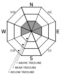
Avalanche Problem 1: Wind Slab
-
Character ?

-
Aspect/Elevation ?
-
Likelihood ?CertainVery LikelyLikelyPossible
 Unlikely
 -
Size ?HistoricVery LargeLargeSmall

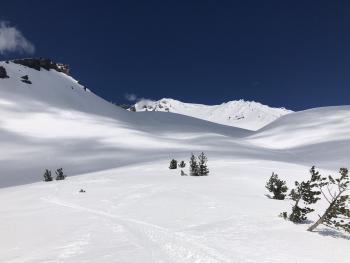
No signs of a wind slab problem were seen yesterday afternoon up to 9,000 feet. Winds have been light and snow moist to wet. If wind slabs exist, expect them high in the alpine regions. As you transition to above treeline elevations where new snow is falling, look for shooting cracks or blocking snow in wind drifted areas of no consequence. This is a sign that wind slabs are forming. Avoid leeward aspects above 35 degrees.
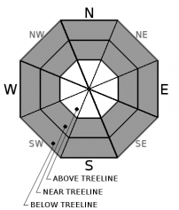
Avalanche Problem 2: Loose Wet
-
Character ?

-
Aspect/Elevation ?
-
Likelihood ?CertainVery LikelyLikelyPossible
Unlikely
-
Size ?HistoricVery LargeLargeSmall
No wet loose avalanches were observed yesterday, though near and below treeline snow was very wet. Continue to be wary of these on steep slopes below treeline. Above freezing temperatures, ankle to knee high boot penetration, very wet snow surfaces, rain-on-snow, and an underlying crust continue to create concern for loose wet avalanches below treeline. Avoid steep slopes where you see roller balls and pinwheels.
Loose Wet avalanches form in new snow or old surface snow that is warming. Warming temperatures, strong solar radiation, or rain-on-snow make the surface snow damp or wet. As the water content increases, the snow becomes unconsolidated. They start at a point and entrain additional snow as they move down hill, and have a characteristic fan-like shape.
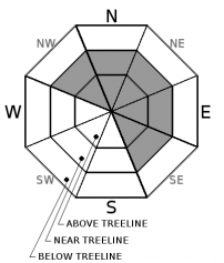
Avalanche Problem 3: Cornice
-
Character ?

-
Aspect/Elevation ?
-
Likelihood ?CertainVery LikelyLikelyPossible
Unlikely
-
Size ?HistoricVery LargeLargeSmall
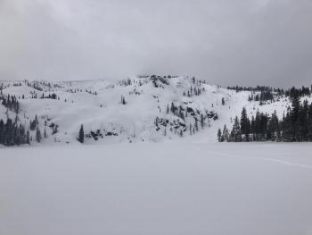
Dropping temperatures may strengthen cornices today. Nonetheless, many large, overhanging cornices reside at elevations transitioning from rain to snow. Continue to be leary of cornices. Don't be above or below them. A falling cornice could trigger loose wet avalanches.
Recent Observations
In the last 24 hours, a little over an inch of rain has fallen near 7,000 ft. Temperatures fell to just below freezing last night. Westerly and southerly winds were light.
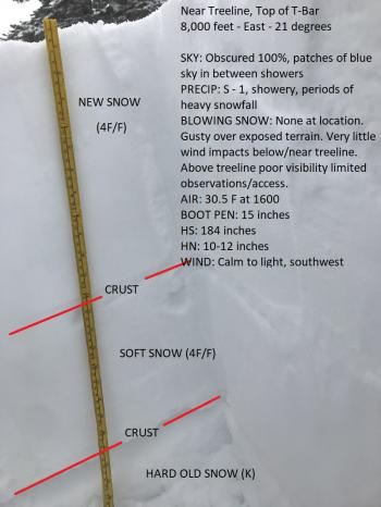
Rain-on-snow and above freezing temperatures turned surface snow near and below treeline very wet. Boot penetration was up to 24 inches. No loose wet avalanches were observed. Rain transitioned to snow above 8,500 feet. About 2.5 inches of new moist snow had accumulated atop a melt-freeze crust by 2 p.m. The snowpack is right side up and no notable column or block tests were observed.
Weather and Current Conditions
Weather Summary
In the next 24 hours, 0.43 inches of precipitable water is expected with most coming before 5 p.m. This will be a mix of rain and snow near and below treeline. Snow levels will be around 6,600 ft. Above treeline snow accumulation could be as much as 5 inches.
We'll see a lull in precipitation tomorrow, but unsettled weather will kick back in Thursday. Up to 3 inches of water is expected by Sunday.
24 Hour Weather Station Data @ 5:00 AM
| Weather Station | Temp (°F) | Wind (mi/hr) | Snow (in) | Comments | ||||||||
|---|---|---|---|---|---|---|---|---|---|---|---|---|
| Cur | Min | Max | Avg | Avg | Max Gust | Dir | Depth | New | Water Equivalent | Settlement | ||
| Mt. Shasta City (3540 ft) | 41 | 41 | 52 | 44.5 | 1 | N | ||||||
| Sand Flat (6750 ft) | 33 | 32 | 38 | 35 | 135 | 0 | 0 | 2 | ||||
| Ski Bowl (7600 ft) | 30.5 | 30.5 | 38 | 33.5 | 179 | 1.6 | 1.18 | 2.8 | ||||
| Gray Butte (8000 ft) | 29 | 29 | 36 | 31.5 | 10 | 25 | WNW | |||||
| Castle Lake (5870 ft) | Station not responding | |||||||||||
| Mount Eddy (6509 ft) | 32.5 | 32.5 | 42 | 36 | 1 | 12 | S | 134.7 | 0 | 5 | ||
| Ash Creek Bowl (7250 ft) | ||||||||||||
| Ash Creek Ridge (7895 ft) |
Two Day Mountain Weather Forecast
Produced in partnership with the Medford NWS
| For 7000 ft to 9000 ft | |||
|---|---|---|---|
|
Tuesday (4 a.m. to 10 p.m.) |
Tuesday Night (10 p.m. to 4 a.m.) |
Wednesday (4 a.m. to 10 p.m.) |
|
| Weather | Rain and snow showers. Some thunder is also possible. Chance of precipitation is 90%. | Rain and snow showers likely, mainly before 11 p.m. Mostly cloudy. Chance of precipitation is 60%. | A 50 percent chance of snow showers. Mostly cloudy. |
| Temperature (°F) | 37 | 30 | 40 |
| Wind (mi/hr) | South 5-10 | South 5-10 | South 5-10 |
| Precipitation SWE / Snowfall (in) | / 1-3 | / <1 | / trace |
| For 9000 ft to 11000 ft | |||
| Tuesday | Tuesday Night | Wednesday | |
| Weather | Snow showers. Some thunder is also possible. Chance of precipitation is 100%. | Snow showers likely, mainly before 11 p.m. Mostly cloudy. Chance of precipitation is 70%. | A 50 percent chance of snow showers. Mostly cloudy. |
| Temperature (°F) | 24 | 22 | 25 |
| Wind (mi/hr) | Southwest 15-20 | Southwest 2-4 | Southwest 5-10 |
| Precipitation SWE / Snowfall (in) | / 2-4 | / <1 | / trace |
Season Precipitation for Mount Shasta City
| Period | Measured (in) | Normal (in) | Percent of Normal (%) |
|---|---|---|---|
| From Oct 1, 2025 (the wet season) | 35.34 | 35.57 | 99 |
| Month to Date (since Jul 1, 2026) | 0.12 | 0.11 | 109 |
| Year to Date (since Jan 1, 2026) | 26.93 | 20.36 | 132 |

