

You are here
Avalanche Forecast for 2019-11-30 07:00
- EXPIRED ON December 1, 2019 @ 7:00 amPublished on November 30, 2019 @ 7:00 am
- Issued by Aaron Beverly - Mount Shasta Avalanche Center
Bottom Line
Avalanche danger will increase from low to moderate as a new, warmer storm delivers significant snow atop an unconsolidated snowpack. Expect storm and wind slabs to form on steep slopes. Hazards exist below light low-density snow. Be careful out there!


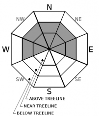
Avalanche Problem 1: Wind Slab
-
Character ?

-
Aspect/Elevation ?
-
Likelihood ?CertainVery LikelyLikelyPossible
 Unlikely
 -
Size ?HistoricVery LargeLargeSmall

Existing and new snow could lead to wind slabs developing today and tonight on northerly aspects near and above treeline. Shooting cracks, blocking, and whumphing are signs that wind slabs may be nearby. Avoid slopes greater than 35 degrees.
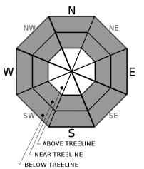
Avalanche Problem 2: Storm Slab
-
Character ?

-
Aspect/Elevation ?
-
Likelihood ?CertainVery LikelyLikelyPossible
Unlikely
-
Size ?HistoricVery LargeLargeSmall
An upside down configuration of snow - firmer snow atop lighter snow creates a concern for storm slabs. You may find them near and below treeline, in wind protected areas, on very steep slopes approaching 40 degrees. The chutes on Gray Butte just right of the big trees is a common place to trigger them.
Storm slabs are a release of a soft cohesive layer of new snow that breaks within the storm snow or on the old snow surface. Storm-slab problems typically last between a few hours and few days.
Forecast Discussion
A "bomb cyclone" transformed Mount Shasta from a dirt pile to a winter wonderland last Tuesday. This was a historic storm, not because of the amount of snow delivered (an impressive 24 inches in less than 24 hours), but because of the lowest barometric pressure ever recorded and the steep pressure gradient that lead to over 100 mph winds on the coast.
The incoming storm will deliver more snow at higher temperatures creating an upside-down configuration - heavier snow atop lighter snow. Conservative estimates are at 10 inches in the next 24 hours. This is a red flag in the avalanche world.
There is, on average, 20 inches of low-density snow below and near treeline. Plenty of hazards are lurking below snow surfaces. Ski and snowmobile lightly. Be patient. Waiting until Tuesday for snow recreation, may be best.
Recent Observations
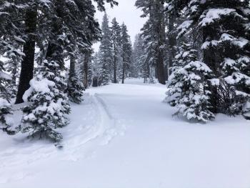
From Sand Flat to the Old Ski Bowl, expect 18 - 25 inches of low density snow. Boot penetration is to the ground. Skiers and snowmobilers will encounter hidden obstacles in the form of rocks, fallen trees, and chaparral. No wind effect was encountered below or near treeline. No obvious signs of avalanche danger were seen.
Weather and Current Conditions
Weather Summary
A blob of low pressure will swing significant precipitation into the area today and tomorrow just in time for holiday travelers returning home. A winter storm warning is in effect from 10 a.m. Saturday to 10 a.m Sunday. The good news for those still reeling from the "bomb cyclone" that shut down I-5 last Tuesday, you may see more rain than snow. Snow levels will rise to 3500 ft by tomorrow. Over the next 24 hours, plan for at least 10 inches. The bulk of the precipitation will come tonight and tomorrow. Precipitation will taper off but will continue until Monday night. Tuesday and Wednesday will be the time to get out to enjoy the results.
Winds will generally be from the south and will be strong enough to transport snow near and above treeline.
More precipitation is on the way later next week.
24 Hour Weather Station Data @ 6:00 AM
| Weather Station | Temp (°F) | Wind (mi/hr) | Snow (in) | Comments | ||||||||
|---|---|---|---|---|---|---|---|---|---|---|---|---|
| Cur | Min | Max | Avg | Avg | Max Gust | Dir | Depth | New | Water Equivalent | Settlement | ||
| Mt. Shasta City (3540 ft) | 32 | 15 | 35 | 29 | 1 | N | ||||||
| Sand Flat (6750 ft) | 20 | 5 | 22 | 17 | 19 | 0 | 0 | 6 | ||||
| Ski Bowl (7600 ft) | 15.5 | 10 | 19.5 | 14.5 | 16.6 | 0 | 0 | 4 | ||||
| Gray Butte (8000 ft) | 14.5 | 11.5 | 17.5 | 14 | 4 | 12 | W | |||||
| Castle Lake (5870 ft) | Not responding | |||||||||||
| Mount Eddy (6509 ft) | 18.5 | 10 | 21.5 | 15 | 1 | 9 | WSW | 15.6 | 0 | 3 | ||
| Ash Creek Bowl (7250 ft) | down | |||||||||||
| Ash Creek Ridge (7895 ft) | down |
Two Day Mountain Weather Forecast
Produced in partnership with the Medford NWS
| For 7000 ft to 9000 ft | |||
|---|---|---|---|
|
Saturday (4 a.m. to 10 p.m.) |
Saturday Night (10 p.m. to 4 a.m.) |
Sunday (4 a.m. to 10 p.m.) |
|
| Weather | Snow. Chance of precipitation is 80%. | Snow. Windy. Chance of precipitation is 100%. | Snow. Windy. Chance of precipitation is 100%. |
| Temperature (°F) | 27 | 18 | 16 |
| Wind (mi/hr) | South 10-15 | South 15-20 | Southeast 15-20 |
| Precipitation SWE / Snowfall (in) | 0.15 / 1-2 | 0.76 / 4-8 | 0.68 / 4-7 |
| For 9000 ft to 11000 ft | |||
| Saturday | Saturday Night | Sunday | |
| Weather | Snow. The snow could be heavy at times. Wind chill values as low as -5. Windy. Chance of precipitation is 80%. | Snow. The snow could be heavy at times. Wind chill values as low as -13. Windy. Chance of precipitation is 100%. | Snow. The snow could be heavy at times. Wind chill values as low as -13. Windy. Chance of precipitation is 100%. |
| Temperature (°F) | 21 | 19 | 21 |
| Wind (mi/hr) | South 20-25 | South 40-50 | South 35-40 |
| Precipitation SWE / Snowfall (in) | 0.15 / 5-7 | 0.76 / 7-10 | 0.68 / 6-10 |
Season Precipitation for Mount Shasta City
| Period | Measured (in) | Normal (in) | Percent of Normal (%) |
|---|---|---|---|
| From Oct 1, 2025 (the wet season) | 2.19 | 7.15 | 31 |
| Month to Date (since Jun 1, 2026) | 1.98 | 4.87 | 41 |
| Year to Date (since Jan 1, 2026) | 39.93 | 35.15 | 114 |

