

You are here
Avalanche Forecast for 2019-12-01 06:55
- EXPIRED ON December 2, 2019 @ 6:55 amPublished on December 1, 2019 @ 6:55 am
- Issued by Ryan Sorenson - Mount Shasta Avalanche Center
Bottom Line
Avalanche danger is moderate. A significant winter storm will add heavy snow atop an unconsolidated snowpack. Storm slabs below and near treeline are likely. Strong southerly winds will build wind slabs on steep leeward terrain. Evaluate terrain carefully before traveling near or on steep slopes.


Avalanche Problem 1: Wind Slab
-
Character ?

-
Aspect/Elevation ?
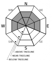
-
Likelihood ?CertainVery LikelyLikelyPossible
 Unlikely
 -
Size ?HistoricVery LargeLargeSmall

Constant wind out of the south coupled with available snow for transport and heavy snowfall will build wind slabs on northerly aspects. Wind speeds have been ideal for wind loading. Average wind speed is 11 mi/hr in the last 24 hours on Gray Butte.
Pay attention to where leeward areas reside. Stay away from steep slopes that have been loaded. Look for signs of the wind slab problem as you travel in safe terrain:
- Shooting cracks, blocking, whumphing
- Convex pillows of wind-drifted snow
- Chalky, hollow sounding snow
Avalanche Problem 2: Storm Slab
-
Character ?

-
Aspect/Elevation ?
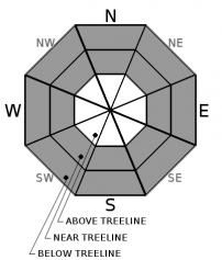
-
Likelihood ?CertainVery LikelyLikelyPossible
Unlikely
-
Size ?HistoricVery LargeLargeSmall
A recent warming trend in the current storm creates a concern for storm slabs. An upside down configuration of snow – firmer snow atop lighter snow is likely. The old snow surface is unconsolidated and light. Be mindful of storm slab avalanches below and near treeline on slopes steeper than 35 degrees.
Storm slabs are a release of a soft cohesive layer of new snow that breaks within the storm snow or on the old snow surface. Storm-slab problems typically last between a few hours and a few days.
Forecast Discussion
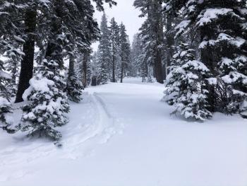
The snow is still unconsolidated and hazards could be lurking below snow surfaces. Ski and snowmobile cautiously.
Giving Tuesday is December 3rd. Please donate! There will be a North State Giving Tuesday party from 6 p.m. to 8 p.m. at the Shasta Mountain Guides storefront, 230 North Mount Shasta Blvd. , Mount Shasta. You can also donate online at www.northstategives.org/FriendsOfTheMountShastaAvalancheCenter. Thank you!
Recent Observations
A short tour up Green Butte ridge yesterday found a shallow snowpack with many obstacles lurking below the snow surface. Variable heights of snow measured 10-22 inches. Blowing snow was actively forming drifts and small wind slabs along the ridge. Some blocking and cracking observed confirmed the existence of wind slab formation.
Snowfall has increased throughout the night and into this morning. Sand Flat is reporting 9 inches of new snow in the last 24 hours. There is currently 20 inches of snow in Mount Shasta City.
Moderate to strong winds have been recorded on Gray Butte in the last 24 hours averaging 11 mi/hr with gusts as high as 37 mi/hr.
Weather and Current Conditions
Weather Summary
A well-defined blob of a winter storm is currently impacting the Mount Shasta area bringing strong southerly winds and snow levels around 3,000 feet. Temperatures are expected to rise throughout the day. The snow level could rise as high as 5,500 feet this evening. Good news for Thanksgiving travelers who should see more rain than snow on the highways and interstate.
Snow is expected to continue to fall in the Mount Shasta area through Monday. There is uncertainty about snow levels but expect a warming trend as the current storm tracks southward.
Another storm is expected to arrive early Thursday morning.
24 Hour Weather Station Data @ 6:00 AM
| Weather Station | Temp (°F) | Wind (mi/hr) | Snow (in) | Comments | ||||||||
|---|---|---|---|---|---|---|---|---|---|---|---|---|
| Cur | Min | Max | Avg | Avg | Max Gust | Dir | Depth | New | Water Equivalent | Settlement | ||
| Mt. Shasta City (3540 ft) | 32 | 15 | 35 | 29 | 1 | N | ||||||
| Sand Flat (6750 ft) | 25 | 19 | 25 | 22 | 25 | 9 | 0.48 | 2 | ||||
| Ski Bowl (7600 ft) | 21.5 | 14 | 21.5 | 18 | 22.6 | 7.6 | 0.02 | 1.4 | ||||
| Gray Butte (8000 ft) | 21.5 | 14.5 | 21.5 | 17.5 | 11 | 37 | SSE | |||||
| Castle Lake (5870 ft) | 0 | 0 | 0 | 0 | 0 | 0 | 0 | Not responding | ||||
| Mount Eddy (6509 ft) | 24.5 | 18 | 24.5 | 21 | 2 | 13 | SSW | 19 | 2 | 0 | ||
| Ash Creek Bowl (7250 ft) | down | |||||||||||
| Ash Creek Ridge (7895 ft) | down |
Two Day Mountain Weather Forecast
Produced in partnership with the Medford NWS
| For 7000 ft to 9000 ft | |||
|---|---|---|---|
|
Sunday (4 a.m. to 10 p.m.) |
Sunday Night (10 p.m. to 4 a.m.) |
Monday (4 a.m. to 10 p.m.) |
|
| Weather | Snow. Windy. Chance of precipitation is 100%. Snow level near 3500 feet. | Snow. Windy. Chance of precipitation is 100%. Snow level rising to 5500 feet. | Snow. Windy. Chance of precipitation is 100%. Snow level near 6000 feet. |
| Temperature (°F) | 30 | 31 | 32 |
| Wind (mi/hr) | South 20-25 | South 10-20 | Southeast 10-15 |
| Precipitation SWE / Snowfall (in) | 0.34 / 3-6 | 0.25 / 2-5 | 0.29 / 3-6 |
| For 9000 ft to 11000 ft | |||
| Sunday | Sunday Night | Monday | |
| Weather | Snow. The snow could be heavy at times. Windy. Strong gusts. Chance of precipitation is 100%. | Snow. The snow could be heavy at times. Windy. Chance of precipitation is 100%. | Snow. The snow could be heavy at times. Chance of precipitation is 100%. |
| Temperature (°F) | 21 | 22 | 26 |
| Wind (mi/hr) | South 40-50 | South 30-35 | South 20-25 |
| Precipitation SWE / Snowfall (in) | 0.34 / 4-8 | 0.25 / 3-6 | 0.29 / 3-6 |
Season Precipitation for Mount Shasta City
| Period | Measured (in) | Normal (in) | Percent of Normal (%) |
|---|---|---|---|
| From Oct 1, 2025 (the wet season) | 2.68 | 7.36 | 36 |
| Month to Date (since Jun 1, 2026) | 2.47 | 5.08 | 49 |
| Year to Date (since Jan 1, 2026) | 40.42 | 35.36 | 114 |

