

You are here
Avalanche Forecast for 2019-12-06 06:32
- EXPIRED ON December 7, 2019 @ 6:32 amPublished on December 6, 2019 @ 6:32 am
- Issued by Nick Meyers - Shasta-Trinity National Forest
Bottom Line
A strong winter storm will impact the forecast area above 5,000 feet over the next 48 hours. Periods of heavy precipitation and southerly gales are certain. Fresh wind slabs are possible near and above treeline. LOW avalanche danger will prevail for most of the daylight hours today, though trending towards MODERATE danger as new snow accumulates and is transported by wind.


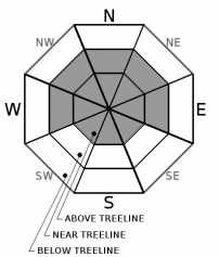
Avalanche Problem 1: Wind Slab
-
Character ?

-
Aspect/Elevation ?
-
Likelihood ?CertainVery LikelyLikelyPossible
 Unlikely
 -
Size ?HistoricVery LargeLargeSmall

New winds slabs will be possible due to new snow and southerly, gale force winds near and above treeline. Wind slabs from new storm snow will load onto existing moist to wet snow surfaces and some areas of crust where overnight freeze occurred. Slabs will be most sensitive to trigger immediately during or just after the storm...late tonight or tomorrow morning. Watch for significant blowing snow, cornices and wind pillows. Pay attention to areas of scouring vs loading patterns causing different snow depths on either side of ridgelines. Travel with caution around any areas where newly formed wind slabs exist.
Forecast Discussion
AVALANCHE! You don't have time to be shell-shocked. You don't have time to do anything other than act. Know how to use your beacon, shovel and probe to execute an avalanche rescue for your partner. Join MSAC professionals for our first of the season, FREE Know Before You Go avalanche awareness presentation (tonight) and companion rescue clinic (tomorrow) of the season.
Avalanche Awareness - Friday, December 6th at 7 p.m. at the Shasta Mountain Guides storefront, 230 N Mt Shasta Blvd, Mount Shasta, CA.
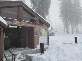
Companion Rescue at Bunny Flat. Meet at The 5th Season store in Mt Shasta City at 9am and we'll caravan to the local trailhead (Bunny Flat) for a half day training. If the road is compromised tomorrow due to the storm, we'll conduct the training on the Sisson ball field. Both of these offerings are FREE of charge. Hope to see you there!
Recent Observations
An attempt was made to repair the Castle Lake weather station yesterday, however it was thwarted by nearly constant drizzle and nasty conditions in the backcountry. I'd share a picture with you, but you shouuld just stare at the nearest white wall while spritzing yourself with a spray bottle full of water. That's about what it was like. In the Castle Lake area, 1 to 1.5 feet of wet, sloppy snow blankets terrain. Manzanita bushes and other terrestrial hazards remain in command. The northerly, shallow end of the lake hosts some ice, albeit supportable only to the smallest critters. Observations from around the forecast area show a wet and well consolidated snowpack around 1 to 2 feet deep in most locations above 6,500 feet. Expect some surface crust where the wetted snowpack has begun to re-freeze. Drizzle/fog was reported to treeline yesterday on the mountain. Above 8,000 feet, the snowpack is likely drier, though observations limited.
Weather and Current Conditions
Weather Summary
Precipitation will spread into the area today and increase in coverage and intensity tonight into Saturday. The heaviest snow is expected Friday night into Saturday morning. A WINTER STORM WARNING remains in effect until 4 PM PST Saturday for elevations above 5,500 feet in Southeastern Siskiyou County. Heavy, wet snow is expected with total snow accumulations of 2 to 3 feet. Occasional southerly wind gusts could be as high as 45 mph. The low providing this wet weather will move onshore Saturday into Sunday and lingering showers are expected Sunday morning. Precipitation will decrease and we will return back to a brief drier pattern for a couple days. The next front moves ashore Tuesday.
24 Hour Weather Station Data @ 5:00 AM
| Weather Station | Temp (°F) | Wind (mi/hr) | Snow (in) | Comments | ||||||||
|---|---|---|---|---|---|---|---|---|---|---|---|---|
| Cur | Min | Max | Avg | Avg | Max Gust | Dir | Depth | New | Water Equivalent | Settlement | ||
| Mt. Shasta City (3540 ft) | 43 | 37 | 44 | 41 | 1 | N | ||||||
| Sand Flat (6750 ft) | 32 | 32 | 35 | 33 | 19 | 0 | .1 | 1 | ||||
| Ski Bowl (7600 ft) | 30 | 29 | 32 | 30.5 | 17.1 | 0 | .1 | 1 | ||||
| Gray Butte (8000 ft) | 29.5 | 28 | 31 | 29.5 | 2 | 25 | SSE | |||||
| Castle Lake (5870 ft) | 0 | 0 | 0 | 0 | 0 | 0 | 0 | not responding | ||||
| Mount Eddy (6509 ft) | 32.5 | 32 | 36 | 33.5 | 2 | 13 | SSW | 22 | 0 | .6 | ||
| Ash Creek Bowl (7250 ft) | down | |||||||||||
| Ash Creek Ridge (7895 ft) | down |
Two Day Mountain Weather Forecast
Produced in partnership with the Medford NWS
| For 7000 ft to 9000 ft | |||
|---|---|---|---|
|
Friday (4 a.m. to 10 p.m.) |
Friday Night (10 p.m. to 4 a.m.) |
Saturday (4 a.m. to 10 p.m.) |
|
| Weather | Snow, windy, snow levels near 5,500 feet | Snow, heavy at times, windy. Snow levels near 5,500 feet | Snow, heavy at times, breezy. Snow levels near 5,200 feet. |
| Temperature (°F) | 37 | 28 | 36 |
| Wind (mi/hr) | South/Southeast 15-20 | South/Southeast 15-20 | South 15-20 |
| Precipitation SWE / Snowfall (in) | 1.13 / 4-8 | 0.78 / 12-18 | 1.32 / 9-15 |
| For 9000 ft to 11000 ft | |||
| Friday | Friday Night | Saturday | |
| Weather | Snow, heavy at times, very windy | Snow, heavy at times, very windy | Snow, heavy at times, very windy |
| Temperature (°F) | 23 | 20 | 21 |
| Wind (mi/hr) | South 40-50 | South 40-50 | South 40-50 |
| Precipitation SWE / Snowfall (in) | 1.13 / 8-15 | 0.78 / 16-21 | 1.32 / 10-16 |
Season Precipitation for Mount Shasta City
| Period | Measured (in) | Normal (in) | Percent of Normal (%) |
|---|---|---|---|
| From Oct 1, 2025 (the wet season) | 3.68 | 8.49 | 43 |
| Month to Date (since Jun 1, 2026) | 1.00 | 1.13 | 88 |
| Year to Date (since Jan 1, 2026) | 41.42 | 36.49 | 114 |

