

You are here
Avalanche Forecast for 2019-12-07 06:17
- EXPIRED ON December 8, 2019 @ 6:17 amPublished on December 7, 2019 @ 6:17 am
- Issued by Nick Meyers - Shasta-Trinity National Forest
Bottom Line
CONSIDERABLE avalanche danger today in near and above treeline terrain due to a wind slab problem from over a foot of new snow overnight and several additional feet of snow forecasted for today, combined with strong southerly wind. Expect MODERATE danger below treeline for storm slabs in protected areas and wind slabs in exposed areas.


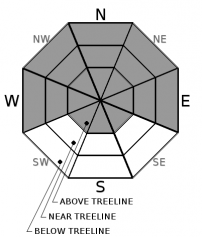
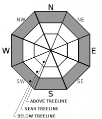
Avalanche Problem 1: Wind Slab
-
Character ?

-
Aspect/Elevation ?
-
Likelihood ?CertainVery LikelyLikelyPossible
 Unlikely
 -
Size ?HistoricVery LargeLargeSmall

Unstable wind slabs are likely for human trigger on slopes where blowing and drifting snow is depositing, below cornices, and in areas where rounded bulges (wind pillows) exist on the upper and middle portion of slopes, near and above treeline. If you see blowing and drifting snow, think unstable wind slabs. Wind has been blowing out of the south/southeast over the past 24 hours, averaging 12 mi/hr and gusting to 30+ mi/hr. Wind speeds are likely higher in exposed, alpine terrain. Wind will continue today out of the south, diminishing later tonight.
Avalanche Problem 2: Storm Slab
-
Character ?

-
Aspect/Elevation ?
-
Likelihood ?CertainVery LikelyLikelyPossible
Unlikely
-
Size ?HistoricVery LargeLargeSmall
Storm slabs are possible below treeline in protected areas as this storm progresses. Storm slab avalanche danger is generally short lived in our snow climate, with the highest likelihood for triggering only lasting a few hours during periods of heavy precipitation. Storm slabs are the release of a cohesive layer (a slab) of new snow that breaks within new snow or on the old snow surface. They form in sheltered areas where new snow falls with light wind. They can occur on any steep slope and are often found on many aspects at the same time. Ski cuts on small, inconsequential test slopes or natural activity on indicator slopes are often the best clues that this problem exists.
Forecast Discussion
Uncertainty remains for today's forecast due to all measurable snow from the active storm falling overnight. Pay attention out there and look for obvious signs of instability like shooting cracks, recent avalanches and blowing snow. Stomp on small, inconsequential test slopes. Continue to watch for shallow buried objects.
Having an avalanche transceiver is only valuable if you know how to use one. In addition, you also want to make sure your competent with probing and shoveling as well as site control, leadership, first aid and evacuation.
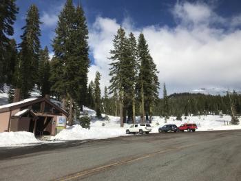
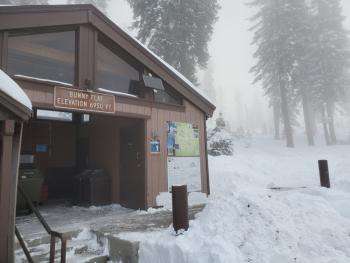
Today, FREE Companion Rescue clinic at Bunny Flat. Meet at The 5th Season store in Mt Shasta City at 9am and we'll caravan to the local trailhead (Bunny Flat) for a half day training. If the road is compromised due to the storm, we'll figure something else out. Dress warm!
Recent Observations
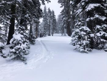
Precipitation on Mount Shasta occurred for most of the day yesterday, but didn't start to pile up as snow until last night around 2200 hours. Bunny Flat at 1300 hours hosted poor visibility, showery conditions and about .5 inches of new snow. Snow levels fluctuated around the 6 to 6,300 foot mark during the daylight hours and has lowered overnight to near 5,500 feet. A solid foot of new snow was recorded overnight at the Old Ski Bowl weather station with wind speeds on Gray Butte averaging 12 mi/hr gusting into the low 30's mi/hr. Temperatures in the last 24 hours have ranged from 28 F to 31 F. The existing snowpack is in good condition to handle new snow loading. A variety of surface crusts have been observed in recent days. Avalanches that may occur today are expected to have snowpack failure occurring in the upper portion of the snowpack.
Weather and Current Conditions
Weather Summary
A winter storm warning remains in effect until 4pm PST this afternoon above 5,500 feet. Southerly wind and heavy snow will continue. Quantitative precipitation forecasts indicate 2 inches of precipitable water for today, which could mean 1.5 to 2 feet of additional snow. Snow levels are predicted near 5,000 feet. This afternoon, the low will come on shore with the bulk of the precipitation shifting to the east. The weather will lighten up and become showery through Sunday morning and eventually clearing by Sunday afternoon. A short break will ensue, only to be followed by an approaching system Tuesday.
24 Hour Weather Station Data @ 5:00 AM
| Weather Station | Temp (°F) | Wind (mi/hr) | Snow (in) | Comments | ||||||||
|---|---|---|---|---|---|---|---|---|---|---|---|---|
| Cur | Min | Max | Avg | Avg | Max Gust | Dir | Depth | New | Water Equivalent | Settlement | ||
| Mt. Shasta City (3540 ft) | 43 | 41 | 44.5 | 43 | 4 | |||||||
| Sand Flat (6750 ft) | 33 | 32 | 33 | 33 | 24 | 5 | 1 | 0 | ||||
| Ski Bowl (7600 ft) | 30 | 28 | 31 | 29.5 | 28 | 12 | 2.37 | 0.4 | ||||
| Gray Butte (8000 ft) | 29 | 27 | 30 | 29 | 12 | 31 | SSE | |||||
| Castle Lake (5870 ft) | 0 | 0 | 0 | 0 | 0 | 0 | 0 | not responding | ||||
| Mount Eddy (6509 ft) | 32 | 31 | 32 | 32 | 2 | 16 | SW | n/a | 0 | 0 | ||
| Ash Creek Bowl (7250 ft) | down | |||||||||||
| Ash Creek Ridge (7895 ft) | down |
Two Day Mountain Weather Forecast
Produced in partnership with the Medford NWS
| For 7000 ft to 9000 ft | |||
|---|---|---|---|
|
Saturday (4 a.m. to 10 p.m.) |
Saturday Night (10 p.m. to 4 a.m.) |
Sunday (4 a.m. to 10 p.m.) |
|
| Weather | Snow, heavy at times, windy. Snow levels near 5,200 feet. | Snow showers, breezy | Snow showers, clearing |
| Temperature (°F) | 35 | 32 | 34 |
| Wind (mi/hr) | South/Southeast 20-30 | South/Southwest 10-15 | Northeast 0-5 |
| Precipitation SWE / Snowfall (in) | 2.03 / 16-22 | 0.19 / 4-8 | 0.03 / 1-2 |
| For 9000 ft to 11000 ft | |||
| Saturday | Saturday Night | Sunday | |
| Weather | Snow, heavy at times, very windy | Snow, heavy at times, windy | Snow showers, blustery |
| Temperature (°F) | 21 | 19 | 24 |
| Wind (mi/hr) | South 40-50 | Southwest 30-40 | East 5-10 |
| Precipitation SWE / Snowfall (in) | 2.03 / 24-30 | 0.19 / 8-12 | 0.03 / 1-3 |
Season Precipitation for Mount Shasta City
| Period | Measured (in) | Normal (in) | Percent of Normal (%) |
|---|---|---|---|
| From Oct 1, 2025 (the wet season) | 5.31 | 8.73 | 61 |
| Month to Date (since Jun 1, 2026) | 2.63 | 1.37 | 192 |
| Year to Date (since Jan 1, 2026) | 43.05 | 36.73 | 117 |

