

You are here
Avalanche Forecast for 2020-02-01 05:23
- EXPIRED ON February 2, 2020 @ 5:23 amPublished on February 1, 2020 @ 5:23 am
- Issued by Nick Meyers - Shasta-Trinity National Forest
Bottom Line
A cold front will move into the area late this afternoon and tonight bringing a small amount of snow, very cold temperatures and windy conditions to higher terrain. LOW avalanche danger is expected to remain for all aspects and elevations. Small, localized wind slabs are possible by tomorrow morning, though not expected to build to significant size. Normal caution is advised. Watch for falling rime ice on the upper mountain.


Avalanche Problem 1: Normal Caution
-
Character ?

-
Aspect/Elevation ?
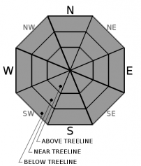
-
Likelihood ?CertainVery LikelyLikelyPossible
 Unlikely
 -
Size ?HistoricVery LargeLargeSmall

Normal caution is advised with an expectation that you will still pay attention to the 5 red flags of avalanche danger at all times! Check out the media below for a quick refresher.
Forecast Discussion
If the clear skies and warm weather lured any climbers onto Mount Shasta this weekend, be prepared for cold temperatures and windy conditions. Precipitation amounts are minimal, but windy, cold weather and poor visibility are likely. Continue to watch out for falling rime ice as well. Remember, you still need a Mt Shasta Wilderness summit pass if climbing above 10,000 feet, even if you don't plan on going to the summit. A wilderness permit and human waste packout bag are also required. All of these items are available for self-issue at the Bunny Flat trailhead or Mount Shasta Ranger Station. Annual passes ($30) are only available at the ranger station during business hours (Mon-Fri, 8AM-4:30PM). Your 3-day pass cannot be upgraded to an annual pass later. Happy climbing!
Recent Observations
- A well-worn and variable snowpack exists. Corn snow, breakable crust, old rain runnels, wind pressed snow, glazed/marblized surfaces and variable sastrugi remains.
- State snow survey courses have begun for the season. Yesterday, the Deadfall Lakes course yielded an average snow depth of 41.5 inches (105 cm) with a 14% water content. This information is submitted to the state for water allocation decisions later in the year.
- Temperatures soared to 57 deg F in the Eddies, 54 deg F at treeline on the mountain and 55 deg F at Castle Lake
- The snowpack has settled several inches over the past couple warm days.
- Little loose snow remains for wind transport
- No signs of avalanche danger
- Active rime ice fall on the upper mountain

Weather and Current Conditions
Weather Summary
The ridge of high pressure that has brought the downright balmy weather over the past couple days will begin to break down today. The frontal boundary of a cold air mass arrives this afternoon. With it will be a bit of precipitation, but not much. Snow levels will crash to valley floors tonight and about .08" of water is forecast with this one. This means only a couple inches of fresh snow, primarily falling tonight. Winds will kick up for a short period this afternoon/evening, especially on the big mountain.
24 Hour Weather Station Data @ 4:00 AM
| Weather Station | Temp (°F) | Wind (mi/hr) | Snow (in) | Comments | ||||||||
|---|---|---|---|---|---|---|---|---|---|---|---|---|
| Cur | Min | Max | Avg | Avg | Max Gust | Dir | Depth | New | Water Equivalent | Settlement | ||
| Mt. Shasta City (3540 ft) | 33 | 31 | 62 | 40.5 | 1 | N | ||||||
| Sand Flat (6750 ft) | 37 | 31 | 51 | 38 | 53 | 0 | 0 | 0 | ||||
| Ski Bowl (7600 ft) | 44 | 39 | 54.5 | 46 | 68.9 | 0 | 0 | .5 | ||||
| Gray Butte (8000 ft) | 43 | 39 | 51.5 | 45 | 17 | 31 | WNW | |||||
| Castle Lake (5870 ft) | 45 | 39 | 55 | 47 | 31.3 | 0 | .5 | |||||
| Mount Eddy (6509 ft) | 44.5 | 35 | 57 | 44.5 | 2 | 9 | WSW | 46.9 | 0 | .5 | ||
| Ash Creek Bowl (7250 ft) | down | |||||||||||
| Ash Creek Ridge (7895 ft) | down |
Two Day Mountain Weather Forecast
Produced in partnership with the Medford NWS
| For 7000 ft to 9000 ft | |||
|---|---|---|---|
|
Saturday (4 a.m. to 10 p.m.) |
Saturday Night (10 p.m. to 4 a.m.) |
Sunday (4 a.m. to 10 p.m.) |
|
| Weather | Partly sunny and breezy. Slight chance of rain and snow this afternoon. Snow level near 6,400 feet. | Mostly cloudy, rain and snow showers likely, becoming all snow after 1 AM, breezy. | Colder, breezy. Mostly cloudy in the morning, then becoming partly cloudy. Chance of snow showers in the morning, mostly before 10 AM. |
| Temperature (°F) | 46 | 19 | 21 |
| Wind (mi/hr) | Southwest 5-15 | Southwest 5-15 | Northwest 5-15 |
| Precipitation SWE / Snowfall (in) | 0.00 / 0 | 0.02 / 1-2 | 0.05 / 0-1 |
| For 9000 ft to 11000 ft | |||
| Saturday | Saturday Night | Sunday | |
| Weather | Partly sunny, windy. Temperature falling to 31 deg F by 5 PM. | Snow showers, mostly cloudy. Windy. | Snow showers, mostly before 10 AM. Cloudy, then becoming mostly sunny and cold. Windy. |
| Temperature (°F) | 35 | 8 | 8 |
| Wind (mi/hr) | Southwest 30-40 | Southwest 35-45 | Northwest 20-30 |
| Precipitation SWE / Snowfall (in) | 0.00 / 0 | 0.02 / 1-2 | 0.05 / 0-1 |
Season Precipitation for Mount Shasta City
| Period | Measured (in) | Normal (in) | Percent of Normal (%) |
|---|---|---|---|
| From Oct 1, 2025 (the wet season) | 12.78 | 22.27 | 57 |
| Month to Date (since Jun 1, 2026) | 3.85 | 7.06 | 55 |
| Year to Date (since Jan 1, 2026) | 3.85 | 7.06 | 55 |

