

You are here
Avalanche Forecast for 2020-02-02 06:30
- EXPIRED ON February 3, 2020 @ 6:30 amPublished on February 2, 2020 @ 6:30 am
- Issued by Aaron Beverly - Mount Shasta Avalanche Center
Bottom Line
Avalanche danger is LOW at all elevations. Less than an inch of new snow is forecasted. Expect firm, dust on crust conditions. An arctic blast will bring strong winds and cold temperatures. Bring the proper clothing and equipment to stay warm in challenging weather.


Avalanche Problem 1: Normal Caution
-
Character ?

-
Aspect/Elevation ?
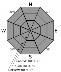
-
Likelihood ?CertainVery LikelyLikelyPossible
 Unlikely
 -
Size ?HistoricVery LargeLargeSmall

Use normal caution while traveling in the backcountry today. This means you should still carry avalanche rescue equipment, have a travel plan, and watch out for isolated slabs. Very small wind slabs may be found and they will not bond well with the underlying snow. They could sweep you off your feet and send you on a ride.
Forecast Discussion
Frigid temperatures are going to harden the snowpack today. With less than an inch of snow expected, be ready for dust on crust conditions. Your skis may easily slip out from under you on steep slopes. Low angle terrain may offer the best skiing if we get a small refresh of snow.
The cold temperatures, combined with moderate to strong winds, will make travel in the alpine dangerous for the unprepared. Bring the proper clothing and an extra hat and pair of gloves in case they get wet. Wind chills will be well below zero.
Recent Observations
In the last 24 hours, Mount Shasta has received no new snow. Temperatures have been mostly above freezing, peaking at 49°F. Winds have been moderate to strong out of the west and northwest above treeline.
Yesterday, below treeline, warm temperatures had softened the surface snow creating posthole conditions up to 10 inches. Above treeline, there was a mix of crusts, wind glazed surfaces, and scabs of wind drifted snow.
Blowing snow was seen high in the alpine, but no wind loading was occurring.

Weather and Current Conditions
Weather Summary
High pressure far off the coast looks to swing in some cold air from Alaska. This combined with moderate to strong north and northwest winds could create some unpleasant conditions on the mountain. Expect below zero wind chills, possibly dropping to -25°F at times. A bit of snow is expected but probably less than an inch.
Cold conditions will continue through Tuesday.
24 Hour Weather Station Data @ 5:00 AM
| Weather Station | Temp (°F) | Wind (mi/hr) | Snow (in) | Comments | ||||||||
|---|---|---|---|---|---|---|---|---|---|---|---|---|
| Cur | Min | Max | Avg | Avg | Max Gust | Dir | Depth | New | Water Equivalent | Settlement | ||
| Mt. Shasta City (3540 ft) | 36 | 33 | 58 | 44 | 2 | N | ||||||
| Sand Flat (6750 ft) | 26 | 0 | 49 | 38 | 0 | 0 | 0 | 1 | ||||
| Ski Bowl (7600 ft) | 24.5 | 24.5 | 49 | 39 | 67.8 | 0 | 0 | 1 | ||||
| Gray Butte (8000 ft) | 22 | 22 | 45 | 35.5 | 23 | 43 | WNW | |||||
| Castle Lake (5870 ft) | 26.5 | 26.5 | 56 | 41.5 | 30.8 | 3.3 | 4 | |||||
| Mount Eddy (6509 ft) | 25.5 | 25.5 | 48.5 | 40 | 2 | 10 | SSE | 44.5 | 0 | 1 | ||
| Ash Creek Bowl (7250 ft) | down | |||||||||||
| Ash Creek Ridge (7895 ft) | down |
Two Day Mountain Weather Forecast
Produced in partnership with the Medford NWS
| For 7000 ft to 9000 ft | |||
|---|---|---|---|
|
Sunday (4 a.m. to 10 p.m.) |
Sunday Night (10 p.m. to 4 a.m.) |
Monday (4 a.m. to 10 p.m.) |
|
| Weather | A 50 percent chance of snow showers. Cloudy, then gradually becoming mostly sunny with falling temperatures Low wind chills. | A 30 percent chance of snow showers Partly cloudy. Low wind chills. | A 30 percent chance of snow showers, mainly before 10 a.m. Mostly sunny. Blustery. Low wind chills. |
| Temperature (°F) | 13 | 10 | 20 |
| Wind (mi/hr) | Northwest 25-30 | North 25-30 | North 30-40 |
| Precipitation SWE / Snowfall (in) | 0.07 / 0-1 | 0.00 / 0 | 0.00 / 0 |
| For 9000 ft to 11000 ft | |||
| Sunday | Sunday Night | Monday | |
| Weather | A 50 percent chance of snow showers. Cloudy, then gradually becoming mostly sunny and cold. Below zero wind chills. Windy. | A 30 percent chance of snow showers. Mostly cloudy. Wind chills as low as -25. Windy. | A 30 percent chance of snow showers, mainly before 10 a.m. Mostly sunny. Very Windy. Wind chills as low as -15. |
| Temperature (°F) | 10 | 1 | 10 |
| Wind (mi/hr) | Northwest 25-30 | North 25-30 | North 30-40 |
| Precipitation SWE / Snowfall (in) | 0.07 / 0-1 | 0.00 / 0 | 0.00 / 0 |
Season Precipitation for Mount Shasta City
| Period | Measured (in) | Normal (in) | Percent of Normal (%) |
|---|---|---|---|
| From Oct 1, 2025 (the wet season) | 12.78 | 22.51 | 57 |
| Month to Date (since Jun 1, 2026) | T | 0.24 | 0 |
| Year to Date (since Jan 1, 2026) | 3.85 | 7.30 | 53 |

