

You are here
Avalanche Forecast for 2020-02-04 06:55
- EXPIRED ON February 5, 2020 @ 6:55 amPublished on February 4, 2020 @ 6:55 am
- Issued by Ryan Sorenson - Mount Shasta Avalanche Center
Bottom Line
Avalanche activity will remain unlikely today as the majority of the existing snowpack is well consolidated and frozen. Warmer temperatures will allow snow surfaces to begin to soften. LOW avalanche danger exists at all elevations.


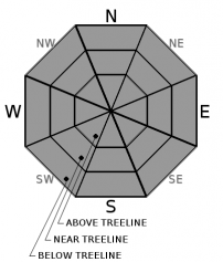
Avalanche Problem 1: Normal Caution
-
Character ?

-
Aspect/Elevation ?
-
Likelihood ?CertainVery LikelyLikelyPossible
 Unlikely
 -
Size ?HistoricVery LargeLargeSmall

The majority of the existing snowpack is well consolidated and frozen. Sheltered slopes host "dust on crust" conditions. Elsewhere, hard icy surfaces remain. Small avalanches in isolated areas or extreme terrain are unlikely, but not impossible. Triggering a small wind slab or loose dry avalanche could sweep you off your feet and send you for a long sliding fall on firm slopes.
Normal caution should be standard for all winter backcountry adventures. This means that you should check the forecast, do a beacon check at the trailhead, and travel wisely through avalanche terrain. Assess the terrain and conditions frequently while maintaining active communication with your group. Build a travel plan with appropriate safety margins. Travel one at a time while crossing steep slopes or avalanche paths.
Forecast Discussion
Warming temperatures should help things soften up today. However, use caution as the current snowpack is firm and icy. Continue to watch out for falling rime ice in the alpine. Wear a helmet if climbing or skiing. You need a Mt Shasta Wilderness summit pass if traveling above 10,000 feet, even if you don't plan on going to the summit. A wilderness permit and human waste packout bag are also required. All of these items are available for self-issue at the Bunny Flat trailhead or Mount Shasta Ranger Station. Annual passes ($30) are only available at the ranger station during business hours (Mon-Fri, 8 AM-4:30 PM).
Recent Observations
- A dusting of new snow over a shallow and well-worn snowpack was observed at Castle Lake yesterday. The one inch of fresh snow barely hides patches of old rain runnels, hard marbleized and icy surfaces, and variable sastrugi.
- In the last 24 hours, Mount Shasta has received no new snow. Temperatures at 7,600 feet reached a high of 20°F yesterday afternoon. Variable winds have been light, averaging 5 mi/hr at 8,000 feet on Gray Butte.
- Yesterday, the state snow survey course near Horse Camp yielded an average snow depth of 60.6 inches (154 cm) with 22.4% water content.


Weather and Current Conditions
Weather Summary
Cold winds out of the northeast today will begin to warm up. Temperatures will reach a high in the lower to mid 30's below and near treeline. Cooler temperatures in the mid to upper 20's will remain at higher elevations. Steady north winds will be in the moderate to strong range. High wispy clouds will skip through the upper atmosphere this afternoon as they try to catch a storm passing to the north.
High-pressure, dry, and clear conditions will dominate the forecast this week. Increasing temperatures and clear blue skies will linger for the foreseeable future.
24 Hour Weather Station Data @ 6:00 AM
| Weather Station | Temp (°F) | Wind (mi/hr) | Snow (in) | Comments | ||||||||
|---|---|---|---|---|---|---|---|---|---|---|---|---|
| Cur | Min | Max | Avg | Avg | Max Gust | Dir | Depth | New | Water Equivalent | Settlement | ||
| Mt. Shasta City (3540 ft) | 23 | 23 | 35 | 25 | 2 | NW | ||||||
| Sand Flat (6750 ft) | 8 | 8 | 20 | 14 | 50 | 0 | 0 | 0 | ||||
| Ski Bowl (7600 ft) | 12.5 | 6.5 | 20.5 | 13 | 67 | 0 | 0 | 0 | ||||
| Gray Butte (8000 ft) | 14 | 7.5 | 20.5 | 12 | 5 | 18 | WSW | |||||
| Castle Lake (5870 ft) | 12.5 | 12.5 | 21.5 | 16.5 | 31.1 | 0 | 0 | |||||
| Mount Eddy (6509 ft) | 16.5 | 11 | 17 | 14 | 2 | 14 | SSE | 50.1 | 0 | 0 | ||
| Ash Creek Bowl (7250 ft) | down | |||||||||||
| Ash Creek Ridge (7895 ft) | down |
Two Day Mountain Weather Forecast
Produced in partnership with the Medford NWS
| For 7000 ft to 9000 ft | |||
|---|---|---|---|
|
Tuesday (4 a.m. to 10 p.m.) |
Tuesday Night (10 p.m. to 4 a.m.) |
Wednesday (4 a.m. to 10 p.m.) |
|
| Weather | Sunny then partly cloudy in the afternoon. | Partly cloudy | Mostly Sunny. |
| Temperature (°F) | 33 | 24 | 41 |
| Wind (mi/hr) | Northeast 10-15 | North 10-15 | Northwest 10-15 |
| Precipitation SWE / Snowfall (in) | 0.00 / 0 | 0.00 / 0 | 0.00 / 0 |
| For 9000 ft to 11000 ft | |||
| Tuesday | Tuesday Night | Wednesday | |
| Weather | Mostly sunny. Windy. Wind chills as low as -5. | Partly Cloudy. Windy. Wind chills as low as -1. | Mostly sunny. Windy. |
| Temperature (°F) | 24 | 24 | 28 |
| Wind (mi/hr) | North 30-35 | North 35-40 | Northwest 35-40 |
| Precipitation SWE / Snowfall (in) | 0.00 / 0 | 0.00 / 0 | 0.00 / 0 |
Season Precipitation for Mount Shasta City
| Period | Measured (in) | Normal (in) | Percent of Normal (%) |
|---|---|---|---|
| From Oct 1, 2025 (the wet season) | 12.90 | 23.00 | 56 |
| Month to Date (since Jun 1, 2026) | 0.12 | 0.73 | 16 |
| Year to Date (since Jan 1, 2026) | 3.97 | 7.79 | 51 |

