

You are here
Avalanche Forecast for 2020-02-27 05:15
- EXPIRED ON February 28, 2020 @ 5:15 amPublished on February 27, 2020 @ 5:15 am
- Issued by Aaron Beverly - Mount Shasta Avalanche Center
Bottom Line
Overall avalanche danger is LOW, though some small loose-wet avalanches may be seen in the afternoon. Be prepared for a firm snowpack at high elevations. Bring an ice axe, crampons, and helmet if making a summit attempt. Beware of falling rock. Expect clear, dry weather until Saturday.


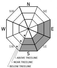
Avalanche Problem 1: Loose Wet
-
Character ?

-
Aspect/Elevation ?
-
Likelihood ?CertainVery LikelyLikelyPossible
 Unlikely
 -
Size ?HistoricVery LargeLargeSmall

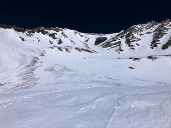
Overall, the avalanche danger is LOW. With two days of above freezing temperatures and warmer temperatures expected today, we may see some small loose wet avalanches. These start at a point and entrain snow as they move down hill. If you are sinking up to your ankles in wet snow, avoid steep, sunlit slopes above terrain traps and cliff areas. Otherwise exercise normal caution.
Forecast Discussion
Firm conditions will exist in sun protected areas and at high elevations. Warmer temperatures will increase the concern for falling rock. Bring an ice axe, crampons, and helmet and know how to use them if making a summit attempt.
Recent Observations
In the last 24 hours, temperatures near treeline on Mount Shasta have ranged from 36 to 48 degrees. Winds have been light to moderate.
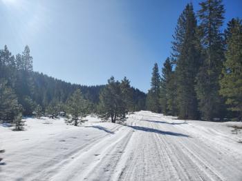
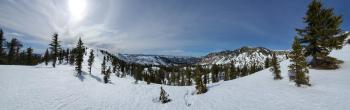
Late spring conditions exist. Overall the snowpack is stable, shallow, and firm with variable snow surfaces. Gullies contain cinders blown from exposed areas. A layer of soft corn snow has been forming on wind-protected, sun-exposed aspects during the late morning to mid-afternoon hours.

Weather and Current Conditions
Weather Summary
A high pressure ridge will continue to keep us dry over the next couple of days. An upper low between Hawaii and Baja will spin air in from the south bringing slightly warmer temperatures today. Winds will be light to moderate.
A cold front looks to cool things down a bit Saturday and could bring a few flurries of snow.
24 Hour Weather Station Data @ 3:00 AM
| Weather Station | Temp (°F) | Wind (mi/hr) | Snow (in) | Comments | ||||||||
|---|---|---|---|---|---|---|---|---|---|---|---|---|
| Cur | Min | Max | Avg | Avg | Max Gust | Dir | Depth | New | Water Equivalent | Settlement | ||
| Mt. Shasta City (3540 ft) | 29 | 28 | 59 | 42.5 | 2 | N | ||||||
| Sand Flat (6750 ft) | 29 | 29 | 49 | 38 | 43 | 0 | 0 | 1 | ||||
| Ski Bowl (7600 ft) | 36 | 35.5 | 48 | 42 | 61 | 0 | 0 | 0.2 | ||||
| Gray Butte (8000 ft) | 36 | 36 | 47 | 40.5 | 9 | 25 | NW | |||||
| Castle Lake (5870 ft) | 40 | 38.5 | 54.5 | 44.5 | 28.6 | 0 | 0 | |||||
| Mount Eddy (6509 ft) | 30.5 | 30.5 | 48 | 38 | 3 | 7 | WSW | 44.7 | 0 | 0 | ||
| Ash Creek Bowl (7250 ft) | down | |||||||||||
| Ash Creek Ridge (7895 ft) | down |
Two Day Mountain Weather Forecast
Produced in partnership with the Medford NWS
| For 7000 ft to 9000 ft | |||
|---|---|---|---|
|
Thursday (4 a.m. to 10 p.m.) |
Thursday Night (10 p.m. to 4 a.m.) |
Friday (4 a.m. to 10 p.m.) |
|
| Weather | Sunny. | Mostly clear. | Mostly sunny. |
| Temperature (°F) | 51 | 33 | 48 |
| Wind (mi/hr) | Northeast 0-5 | East 0-5 | South 5-10 |
| Precipitation SWE / Snowfall (in) | 0.00 / 0 | 0.00 / 0 | 0.00 / 0 |
| For 9000 ft to 11000 ft | |||
| Thursday | Thursday Night | Friday | |
| Weather | Sunny. | Mostly Clear | Mostly sunny. Windy. |
| Temperature (°F) | 33 | 30 | 30 |
| Wind (mi/hr) | North 15-20 | Southeast 10-15 | Southwest 15-20 |
| Precipitation SWE / Snowfall (in) | 0.00 / 0 | 0.00 / 0 | 0.00 / 0 |
Season Precipitation for Mount Shasta City
| Period | Measured (in) | Normal (in) | Percent of Normal (%) |
|---|---|---|---|
| From Oct 1, 2025 (the wet season) | 12.90 | 28.96 | 45 |
| Month to Date (since Jun 1, 2026) | 0.12 | 6.69 | 2 |
| Year to Date (since Jan 1, 2026) | 3.97 | 13.75 | 29 |

