

You are here
Avalanche Forecast for 2021-01-26 06:58
- EXPIRED ON January 27, 2021 @ 6:58 amPublished on January 26, 2021 @ 6:58 am
- Issued by Aaron Beverly - Mount Shasta Avalanche Center
Bottom Line
Avalanche danger will increase to HIGH over the next 24 hours while a significant storm impacts the area. Moderate to gale force winds, 17-26 inches of new snow, 8 inches of recent snow and a firm widespread crust will combine to create dynamic and challenging conditions. Natural and human triggered avalanches will be likely. Be prepared for very cold temperatures and delays on I5. Everitt Memorial Highway and Castle Lake Road will be closed after noon today.


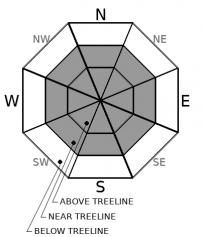
Avalanche Problem 1: Wind Slab
-
Character ?

-
Aspect/Elevation ?
-
Likelihood ?CertainVery LikelyLikelyPossible
 Unlikely
 -
Size ?HistoricVery LargeLargeSmall

We are expecting 17-26 inches of snow in the next 24 hours. This new snow will pile on top of a layer of low density snow that is not well bonded with the widespread crust underneath. This older snow may already be forming wind slabs before today's storm kicks in. This will only add to the instability. South winds will be in the moderate to gale force range. Moderate winds are usually the most productive is forming wind slabs. Be aware of these near slopes over 30 degrees. Shooting cracks, blocking snow, hollow sounding snow, and whumphing are signs of nearby wind slabs. Test for these conditions as you travel in safe terrain. It is recommended that you stay in safe terrain as this storm increases in its intensity.
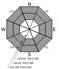
Avalanche Problem 2: Storm Slab
-
Character ?

-
Aspect/Elevation ?
-
Likelihood ?CertainVery LikelyLikelyPossible
Unlikely
-
Size ?HistoricVery LargeLargeSmall
Steady, cold temperatures may keep storm slabs from forming, but be prepared for them on steep slopes over 40 degrees. New snow will not bond well with the old snow and there is a widespread crust underneath that presents a perfect bed surface.
You usually find storm slabs near and below treeline where slopes are more protected from the wind. The west side of Gray Butte, down in the chutes is classic storm slab location.
Avalanche Problem 3: Loose Dry
-
Character ?

-
Aspect/Elevation ?

-
Likelihood ?CertainVery LikelyLikelyPossible
Unlikely
-
Size ?HistoricVery LargeLargeSmall
Like storm slabs, loose dry sloughs tend to slide on slopes greater than 40 degrees. Dry, unbonded snow atop a firm crust will create the right conditions for these to occur. They are less dangerous than slab avalanches, but can sweep you off your feet into terrain traps or cliff areas.
Forecast Discussion
As this storm kicks in, remember that there are other hazards out there besides avalanches. Dress warmly, be prepared for delays on I5, and stay clear of tree wells. Be ready for heightened avalanche danger over the next several days. We may receive 5-6 feet of snow by Thursday night. This is the kind of storm that can produce very large avalanches.
Everitt Memorial Highway and Castle Lake Road will be closed after Noon today to give the county plow drivers room to work. Rangers will be performing a sweep of these roads prior to gate closure.
Recent Observations
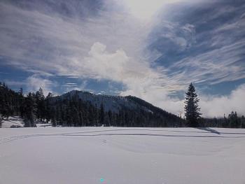
Sunday's storm delivered about 8 inches of light density snow. During the beginning of the storm, Gray Butte reported light west winds that dropped to below 5 mi/hr through most of Monday. In the last 24 hours, SE winds have averaged 4 mi/hr and temperatures 12 ºF.
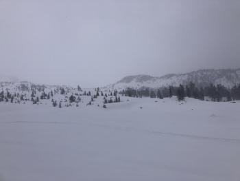
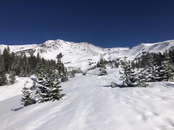
A tour of the Old Ski Bowl and Gray Butte saw little wind effect and no signs of avalanches. A bit of sloughy behavior was triggered on slopes greater than 40 degrees. The upper mountain has filled in a bit, but plenty of rocks are still exposed.
New snow sits atop a widespread stout crust.
More wind effect was seen on Green Butte Ridge and a small D1 wind slab avalanche occurred on Spring Hill in Avalanche Gulch. See pic below:
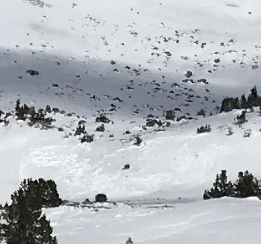
Photo by Matt Hill

Weather and Current Conditions
Weather Summary
Today begins the storm we've all been talking about and waiting for. It's gonna be a doozy. A winter storm warning is in effect from noon today to 4 p.m. Wednesday.
Here's what we are expecting for snow:
- 10 a.m. - 10 p.m.: 9-14 in
- 10 p.m. - 4 a.m.: 8-12 in
- 4 a.m. - 10 p.m. (Wednesday): 18-25 in
By Thursday night we are looking at 5.16 inches of precipitable water which may translate into 5 feet of snow.
Southerly winds will start off in the moderate range and will turn to gale force tonight and tomorrow. Temps will be well below freezing, snow levels will be below town. You would be wise to avoid travel on I5 after noon today. Expect dangerously low wind chills.
24 Hour Weather Station Data @ 6:00 AM
| Weather Station | Temp (°F) | Wind (mi/hr) | Snow (in) | Comments | ||||||||
|---|---|---|---|---|---|---|---|---|---|---|---|---|
| Cur | Min | Max | Avg | Avg | Max Gust | Dir | Depth | New | Water Equivalent | Settlement | ||
| Mt. Shasta City (3540 ft) | 21 | 21 | 43 | 32 | 3 | N | ||||||
| Sand Flat (6750 ft) | 4 | 3 | 21 | 11 | 0 | 0 | snow depth sensor broken | |||||
| Ski Bowl (7600 ft) | 7 | 7 | 20 | 11.5 | 45.2 | 0 | 0.01 | 2 | ||||
| Gray Butte (8000 ft) | 8.5 | 8.5 | 18 | 11 | 4 | 18 | SE | |||||
| Castle Lake (5870 ft) | 13 | 12.5 | 18.5 | 16 | 27.2 | 21.4 | 0 | snow depth sensor broken | ||||
| Mount Eddy (6509 ft) | 8.5 | 6.5 | 18 | 13 | 2 | 6 | SSE | 40.4 | 28.7 | 0 | ||
| Ash Creek Bowl (7250 ft) | 10.5 | 6 | 15 | 11 | 37.7 | 0 | 1.2 | |||||
| Ash Creek Ridge (7895 ft) | 6.5 | 5.5 | 13.5 | 8 | 1 | 18 |
Two Day Mountain Weather Forecast
Produced in partnership with the Medford NWS
| For 7000 ft to 9000 ft | |||
|---|---|---|---|
|
Tuesday (4 a.m. to 10 p.m.) |
Tuesday Night (10 p.m. to 4 a.m.) |
Wednesday (4 a.m. to 10 p.m.) |
|
| Weather | Snow likely, mainly after 1 p.m. Patchy blowing snow after 10 a.m. Increasing clouds. Low wind chill. Breezy. Chance of precipitation is 70%. | Snow. The snow could be heavy at times. Widespread blowing snow. Low wind chills. Windy. Chance of precipitation is 100%. | Snow. The snow could be heavy at times. Widespread blowing snow, mainly before 4 p.m. Windy. Chance of precipitation is 90%. |
| Temperature (°F) | 19 | 20 | 26 |
| Wind (mi/hr) | South 5-10 | South 20-25 | South 20-25 |
| Precipitation SWE / Snowfall (in) | 0.90 / 9-14 | 0.78 / 8-12 | 1.67 / 18-25 |
| For 9000 ft to 11000 ft | |||
| Tuesday | Tuesday Night | Wednesday | |
| Weather | Snow likely, mainly after 1 p.m. Widespread blowing snow after 10 a.m. Increasing clouds. Low wind chills. Windy. Chance of precipitation is 70%. | Snow. The snow could be heavy at times. Widespread blowing snow. Windy. Low wind chills. Chance of precipitation is 100%. | Snow. The snow could be heavy at times. Widespread blowing snow. Low wind chill values. Windy. Chance of precipitation is 90%. New snow accumulation of 10 to 16 inches possible. |
| Temperature (°F) | 15 | 9 | 15 |
| Wind (mi/hr) | Southwest 20-25 | Southwest 80-90 | South 50-60 |
| Precipitation SWE / Snowfall (in) | 0.90 / 9-14 | 0.78 / 8-12 | 1.67 / 18-25 |
Season Precipitation for Mount Shasta City
| Period | Measured (in) | Normal (in) | Percent of Normal (%) |
|---|---|---|---|
| From Oct 1, 2025 (the wet season) | 6.20 | 21.00 | 30 |
| Month to Date (since Jun 1, 2026) | 2.62 | 5.79 | 45 |
| Year to Date (since Jan 1, 2026) | 2.62 | 5.79 | 45 |

