

You are here
Avalanche Forecast for 2021-01-27 06:45
- EXPIRED ON January 28, 2021 @ 6:45 amPublished on January 27, 2021 @ 6:45 am
- Issued by Aaron Beverly - Mount Shasta Avalanche Center
Bottom Line
Avalanche danger is EXTREME. Travel in or near avalanche terrain should be avoided. Up to 24 inches of snow could fall today and tonight adding more weight to the 21 inches that has fallen. This snow will not be bonded to the underlying crust supporting it. Natural avalanches are certain. Be aware and be safe in the snow and on the highways. Everitt Memorial Highway and Castle Lake Road are closed.


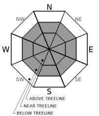
Avalanche Problem 1: Wind Slab
-
Character ?

-
Aspect/Elevation ?
-
Likelihood ?CertainVery LikelyLikelyPossible
 Unlikely
 -
Size ?HistoricVery LargeLargeSmall

So far we have received 21 inches of new snow accompanied by moderate southerly winds. Winds slabs are bound to be found today either sitting on a slick crust or on the low density snow from Sunday, which will be sitting unbonded to the same slick crust. They could be several feet thick. Moderate winds are the most productive for forming wind slabs. Significant snow today will add more weight to those slabs and slabs will continue to build. Stay well clear of leeward terrain. Wind slab avalanches are almost certain today.
Shooting cracks, blocking snow, hollow sounding snow, and whumphing are signs of nearby wind slabs. Test for these conditions as you travel in safe terrain and stay in safe terrain.
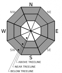
Avalanche Problem 2: Storm Slab
-
Character ?

-
Aspect/Elevation ?
-
Likelihood ?CertainVery LikelyLikelyPossible
Unlikely
-
Size ?HistoricVery LargeLargeSmall
Storm slabs are likely today on steep slopes near 40 degrees. Warmer temperatures will create a slightly upside down snowpack with a top layer potentially acting as a soft cohesive layer (a slab). Snow from yesterday and Sunday will not be well bonded to the slick crust it sits on.
You usually find storm slabs near and below treeline where slopes are more protected from the wind. The chutes on Gray Butte near the trees is a classic location where they form.
Avalanche Problem 3: Loose Dry
-
Character ?

-
Aspect/Elevation ?

-
Likelihood ?CertainVery LikelyLikelyPossible
Unlikely
-
Size ?HistoricVery LargeLargeSmall
Like storm slabs, loose dry sloughs tend to slide on slopes greater than 40 degrees. Dry, unbonded snow atop a firm crust will create the right conditions for these to occur. They are less dangerous than slab avalanches, but can sweep you off your feet into terrain traps or cliff areas.
Forecast Discussion
Two obvious signs of avalanche danger are significant snow in a 24 hour period and winds. We have had these and will have them again today. Avalanches could be very large and could travel long distances. Be aware of where you are and the terrain you are above and below.
Beware of all hazards today. Driving will be frustrating. Take is slow. Dress warmly. Avoid tree wells. Travel with a partner.
Everitt Memorial Highway and Castle Lake Road are closed.
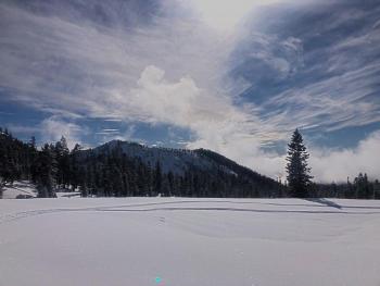
Recent Observations
As of 5 a.m. we are well on track to receive 24 hour forecasted snow totals. The Old Ski Bowl weather station is reporting 21 inches of new snow, which began accumulating around 2 p.m. yesterday. Southerly winds have been moderate all night, maxing at 20 mi/hr and gusting up to 49. Temperatures have averaged 11.5 ºF. Castle Lake reports 14 inches of new snow.
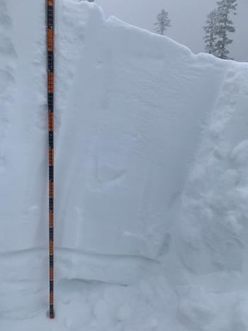
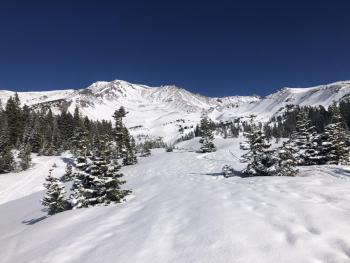
We dug down deep into the snow pack to see if any lurking weak layers could be found of concern. Though there are still some old sugary layers to be found, they are few, have strengthened, and are sandwiched between stout crusts. Column tests yielded hard failures and no failures. I mention this as there have been rumors of a persistent weak layer in Tahoe. We just aren't finding evidence of one here.
The main concern is the widespread slippery crust left over from a week of melt-freeze cycles and scouring winds. Snowmobiles and boots slipped easily on this crust and snow is not bonded to it. Southerly winds were kicking up by the time we headed down and wind effects on the snow were beginning to be seen. More signs of wind related instabilities, such as cracking and blocking, were seen in the Eddies.
Weather and Current Conditions
Weather Summary
Get ready for another round of wintry weather. A winter storm warning is in effect until 10 p.m. this evening.
Here's what we are expecting for snow near and above treeline:
- 10 a.m. - 10 p.m.: 10-20 in
- 10 p.m. - 4 a.m.: 2-6 in
- 4 a.m. - 10 p.m. (Thursday): 3-10 in
Another 2.73 inches of precipitable water is left in this storm which should diminish by Thursday night.
Southerly winds will be moderate to strong today and will begin to taper off tonight. Snow levels will remain low, though temperatures will be slightly higher with mid-20s expected near treeline. Travel advisories remain in effect and avoiding I-5 if possible will keep your stress levels down.
24 Hour Weather Station Data @ 6:00 AM
| Weather Station | Temp (°F) | Wind (mi/hr) | Snow (in) | Comments | ||||||||
|---|---|---|---|---|---|---|---|---|---|---|---|---|
| Cur | Min | Max | Avg | Avg | Max Gust | Dir | Depth | New | Water Equivalent | Settlement | ||
| Mt. Shasta City (3540 ft) | 27 | 27 | 27 | 27 | N | |||||||
| Sand Flat (6750 ft) | 17 | 4 | 17 | 15 | snow sensor broken | |||||||
| Ski Bowl (7600 ft) | 14 | 7 | 15.5 | 12 | 67.4 | 21.6 | 1.26 | 0 | ||||
| Gray Butte (8000 ft) | 12.5 | 8.5 | 12.5 | 10.5 | 13 | 49 | S | |||||
| Castle Lake (5870 ft) | 19 | 13 | 19 | 17.5 | 43.2 | 15.1 | 0 | |||||
| Mount Eddy (6509 ft) | 17.5 | 8.5 | 17.5 | 15 | 3 | 9 | WSW | 58.2 | 16.8 | 0 | ||
| Ash Creek Bowl (7250 ft) | 15.5 | 10.5 | 15.5 | 13 | 46.8 | 8.1 | 0 | |||||
| Ash Creek Ridge (7895 ft) | 12 | 6.5 | 12 | 9.5 | 11 | 125 | S | wind sensor now rimed |
Two Day Mountain Weather Forecast
Produced in partnership with the Medford NWS
| For 7000 ft to 9000 ft | |||
|---|---|---|---|
|
Wednesday (4 a.m. to 10 p.m.) |
Wednesday Night (10 p.m. to 4 a.m.) |
Thursday (4 a.m. to 10 p.m.) |
|
| Weather | Snow. The snow could be heavy at times. Widespread blowing snow. Windy. Low wind chills. Chance of precipitation is 100%. | Snow showers. Windy. Chance of precipitation is 90%. | Snow showers likely, mainly before 5 p.m. Mostly cloudy. Breezy. Chance of precipitation is 70%. |
| Temperature (°F) | 26 | 26 | 27 |
| Wind (mi/hr) | South 20-25 | South 20-25 | South 10-15 |
| Precipitation SWE / Snowfall (in) | 1.75 / 10-18 | 0.36 / 2-4 | 0.62 / 3-7 |
| For 9000 ft to 11000 ft | |||
| Wednesday | Wednesday Night | Thursday | |
| Weather | Snow. The snow could be heavy at times. Widespread blowing snow. Windy. Low wind chills. Chance of precipitation is 100%. | Snow showers. The snow could be heavy at times. Windy. Low wind chills. Chance of precipitation is 90%. | Snow showers likely, mainly before 4 p.m. Mostly cloudy. Windy. Low wind chills. Chance of precipitation is 70%. |
| Temperature (°F) | 14 | 14 | 16 |
| Wind (mi/hr) | South 65-70 | South 60-70 | South 35-45 |
| Precipitation SWE / Snowfall (in) | 1.75 / 12-20 | 0.36 / 4-6 | 0.62 / 6-10 |
Season Precipitation for Mount Shasta City
| Period | Measured (in) | Normal (in) | Percent of Normal (%) |
|---|---|---|---|
| From Oct 1, 2025 (the wet season) | 7.52 | 21.22 | 35 |
| Month to Date (since Jul 1, 2026) | 3.94 | 6.01 | 66 |
| Year to Date (since Jan 1, 2026) | 3.94 | 6.01 | 66 |

