A meandering tour was taken up in the Castle Lake area yesterday, with intentions of checking on the near surface facet situation. Learn more about snow metamorphism here. Check out the full observation from Castle Lake here. Soft, sugary, near surface facets were found below and near treeline on protected, shady, northerly aspects. This snow is great to ski at this point, but can be a weak layer should we receive any new snow...which is not likely in the near future. None-the-less, when we do receive more snow, those slopes may be avalanche prone.
Overall, we are in a holding pattern. Chilly nights and warm days have been the norm. We've had a few periods of high wind, but lately, air stagnation advisories have been in effect. One could host a candlelight vigil out there...it's been quite nice with no shortage of vitamin sun.
In the past 24 hours, temperatures near treeline have ranged from 34 to 41 °F. Wind near and above treeline has been blowing out of the E-NE. Wind speeds reached 49 mi/hr, averaging 20-30 mi/hr. This morning, it is mostly calm.
Snow surfaces are widely variable, firm in the morning and soft in the afternoon on sunny slopes. Sugary, soft snow can be found on northerlies. Anything hit by the wind is scoured to crusts, or exposed rocks.
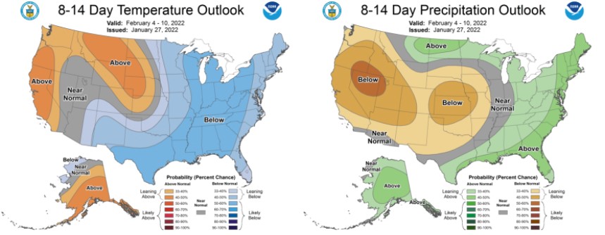
Oy vey! I can take a little dry spell, but it is starting to get ridiculous around here. We haven't had any precipitation since January 8th and the 8-14 day outlook is predicting below normal precipitation and above normal temperatures. As an avalanche forecaster, I suppose it's a good time to take a vacation! A strong upper level ridge is in place over the western U.S. This ridge will weaken and move east on Sunday. Until then, a stagnant pattern will persist over the area with mostly clear skies, mellow wind, chilly nights and big, blue, beautiful days. Check out more climate models and images like the one below at the NOAA Climate Predication Center.