Submitted by mmadden on Sun, 01/01/2023 - 4:52am
Recent Observations:
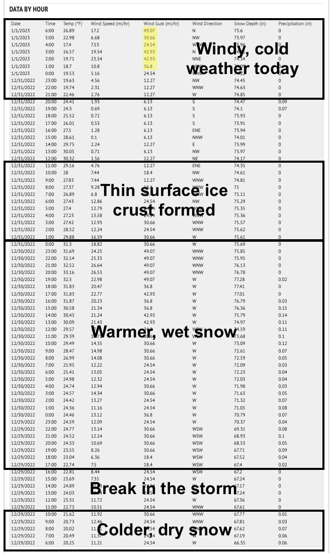
The aftermath of numerous avalanches were reported to Mt. Shasta Avalanche Center yesterday. These were all found above treeline and occurred from a warm period late December 29th and on the 30th. Below freezing temperatures overnight on the 30th created a thin ice crust on the snow surface near and below treeline. This actually made for excellent snowboarding conditions in the near treeline zone on Mt. Shasta. Windy conditions and variable snow surfaces were observed in the Castle Lake area yesterday.
Dangerous avalanche conditions on December 30th were confirmed by the finding of numberous avalanches on December 31st. Here is a summary of the red flags from the 30th:
- Mt Shasta, near treeline, Old Ski Bowl, ~8,000 feet, upside down cake snowpack structure: dense, light wind affected snow on top of softer, lower density snow. Slabs ~1 foot thick were easily triggered in pit tests with moderate (Q2) shear quality. Areas with a touch of wind and stiff snow near the surface had the most sensitive test results.
- Whumpfing felt and heard near treeline in same area of snow pit and stability tests
- Shooting cracks observed near treeline in the Gray Butte / Mt. Shasta Ski Park area
- Cracking and blocking observed along small test slopes on Green Butte Ridge
- Westerly wind was moderate and spatially variable
- Warming occurred in the afternoon. Snow levels fluctuated between 6,000 to 7,000 feet
Below, Old Ski Bowl and Gray Butte weather station data from before and after the recent storms:
Mountain Weather:
The stormy weather from an atmospheric river event has tapered off. The associated low pressure system has moved southeast and is dissipating. Sunny and clear conditions can be expected today. While relatively low freezing levels will leave temperatures in the 20s and upper teens, moderate-to-strong winds will bring wind-chill temperatures into the single digits.
Another low pressure system, this one near the Gulf of Alaska, will bring back stormy weather tomorrow. We can expect precipitation and cloud cover to remain for most of the week. Overall, it looks to be an excellent chance to improve drought conditions and build sorely needed mountain snowpack.
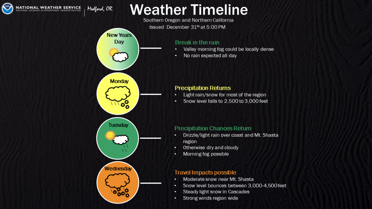
Source: NWS Medford, "Calm before storm"
Today 7-8 Weather :
Sunny and clear with breezy conditions in the morning. Freezing level ~3,600'
Today 7-8 Wind Direction:
NNW
Today 8-9 Weather:
Sunny and clear with moderate-strong winds creating cold wind chill temperatures.
Today 8-9 Wind Direction:
N
Tomorrow 7-8 Weather:
Overcast with a 90% chance of new snow. Breezy. Freezing level ~3,400'
Tomorrow 7-8 Wind Direction:
SE
Tomorrow 8-9 Weather:
Overcast and new snow. Moderate winds creating cold wind chill temperatures.
Tomorrow 8-9 Wind Direction:
SW
Tonight 7-8 Weather:
Gradually increasing clouds becoming mostly cloudy by early morning. 30% chance of precipitation. Freezing level ~3,900'
Tonight 7-8 Wind Direction:
NE
Tonight 8-9 Weather:
Gradually increasing clouds becoming mostly cloudy by early morning. Moderate winds creating cold wind chill temperatures.
Tonight 8-9 Wind Direction:
NW
21
20
33
29
51
0
0
17.5
16.5
30.5
25
73.96
0
0.16
Grey Butte Wind Max:
23.5
Grey Butte Wind Gust Max:
42.93
Mount Eddy Temp Avg:
27.5
Mount Eddy Wind Gust Max:
6.73
Mount Eddy Snow Depth:
43
Ash Creek Bowl Temp Cur:
20
Ash Creek Bowl Temp Min:
20
Ash Creek Bowl Temp Max:
30.5
Ash Creek Bowl Temp Avg:
26
Ash Creek Bowl Snow New:
0
Ash Creek Ridge Temp Cur:
16.5
Ash Creek Ridge Temp Min:
16.5
Ash Creek Ridge Temp Max:
26.5
Ash Creek Ridge Temp Avg:
22.5
Ash Creek Ridge Wind Cur:
2
Ash Creek Ridge Wind Max:
9
Ash Creek Ridge Wind Gust Max:
17.65
Ash Creek Ridge Wind Avg:
W
Mt. Shasta City Temp Cur:
34
Mt. Shasta City Temp Min:
34
Mt. Shasta City Temp Max:
43
Mt. Shasta City Temp Avg:
38.5
Mt. Shasta City Wind Cur:
10
Mt. Shasta City Wind Min:
0
Mt. Shasta City Wind Max:
11
Mt. Shasta City Wind Avg:
5
Mt. Shasta City Wind Avg:
NW
Ash Creek Ridge Wind Min:
2
Ash Creek Ridge Wind Avg:
5
Sand Flat Snow Settlement:
2
Ski Bowl Snow Settlement:
1.3
Mount Eddy Snow Settlement:
1.3
Ash Creek Bowl Snow Settlement:
40.5
Measured Precipitation Oct:
9.13
Normal Precipitation Oct:
12.24
Percent Precipitation Oct:
75
Measured Precipitation MTD:
5.8
Normal Precipitation MTD:
6.61
Percent Precipitation MTD:
88
Measured Precipitation YTD:
17.08
Normal Precipitation YTD:
37.62
Percent Precipitation YTD:
45
Tomorrow Wind Max 7-9:
22
Tomorrow Wind Min 7-9:
12
Tonight Wind Max 9-11:
22
Tomorrow Wind Max 9-11:
30
Tonight Wind Min 9-11:
12
Tomorrow Wind Min 9-11:
20
Tonight Snow Max 7-9:
0.50
Tomorrow Snow Max 7-9:
3.00
Tonight Snow Min 7-9:
0.00
Tomorrow Snow Min 7-9:
1.00
Today Snow Max 9-11:
0.00
Tonight Snow Max 9-11:
0.50
Tomorrow Snow Max 9-11:
4.00
Today Snow Min 9-11:
0.00
Tonight Snow Min 9-11:
0.00
Tomorrow Snow Min 9-11:
2.00
Weather Station Discussion:
The table below summarizes data reported from all of our weather stations over the last 24 hours.
Seasonal Stats Discussion:
The wet season is October 1 through May 1. The table below summarizes recorded vs. normal precipitation amounts for the City of Mount Shasta.
Overall Danger Rating:
Moderate


