Submitted by nmeyers on Fri, 12/24/2021 - 5:49am
Recent Observations:
Yesterday was a moist, soggy and foggy day, despite below freezing temperatures on the mountain. Light rain was observed in town for most of the day. Snow levels fluctuated around 4,500 to 5,000 feet. Freezing fog stuck to your goggles rendering visibility difficult. A light zipper crust formed on most aspects below 7,000 feet. Existing powder turned to moist, mashed taters below treeline, but is much dryer and more winter-like near and above treeline. New snow over the past 24 hours has been minimal, but about 10-13 inches has accumulated over the past 3 days with 1.15 inches of water. Above treeline terrain has been difficult to access. The wind has been notable up there however, with our Gray Butte station showing consistent SW-W-NW wind blowing 15-20 mi/hr with gusts to 35-40 mi/hr over the past 24 hours. On the mountain, max temps have not climbed above 26 F. On the west side, Castle Lake reached 32 F.
We dug a pit near treeline on an easterly aspect, in an area with no wind effect. Moderate to hard, non-planar failures (ECTN22/CT15) were induced about 20 inches down from the surface, at a density change interface. This weak layer was stubborn to trigger. See full observation here.
Mountain Weather:
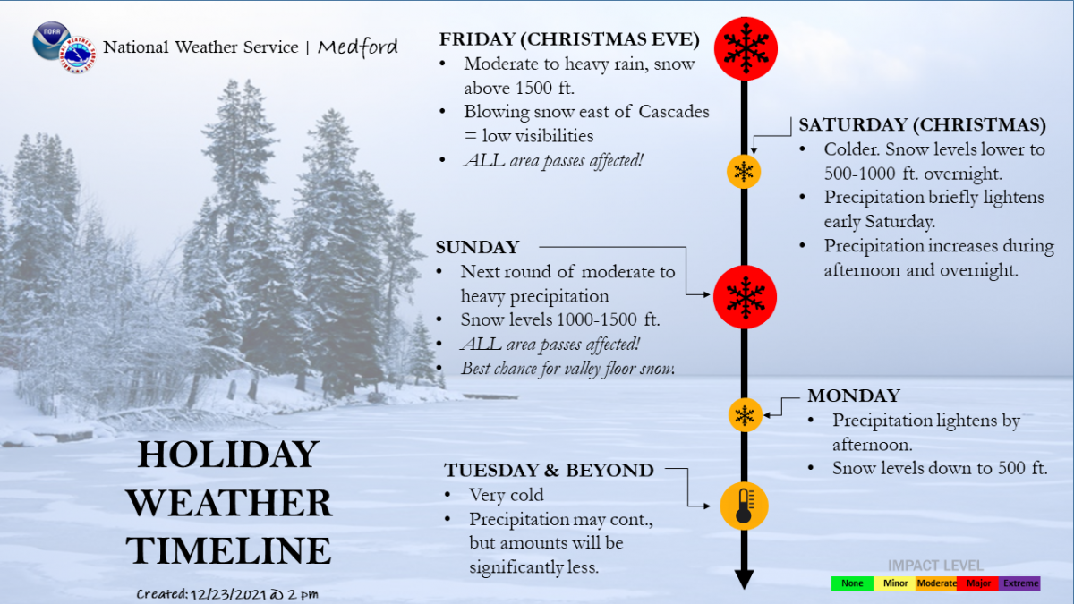
A winter storm warning is in effect from 1 PM this afternoon to 10 AM PST Monday. As we speak this morning, we are in a lull in the weather. A cold front sits offshore and will begin to head our way later today. Snow levels will start low due to a large cold air mass associated with this system. Expect high temperatures in the single digits above treeline on the mountain. Precipitation should be ongoing throughout the weekend. Southern Oregon looks to get the brunt of the storm, but we won't be left empty-handed. Take a gander at the visuals below to game out the weekend. Needless to say, it's going to be a white Christmas and Rudolph will need to shine that nose so bright.
Today 7-8 Weather :
Snow, patchy blowing snow, mainly after 10am. Chance of precipitation 80%, windy
Today 7-8 Wind Direction:
SW
Today 8-9 Weather:
Snow, widespread blowing snow, very windy
Today 8-9 Wind Direction:
W
Tomorrow 7-8 Weather:
Snow, chance of precipitation 80%
Tomorrow 7-8 Wind Direction:
SW
Tomorrow 8-9 Weather:
Snow, widespread blowing snow, very windy
Tomorrow 8-9 Wind Direction:
SW
Tonight 7-8 Weather:
Snow, widespread blowing snow. Chance of precipitation 90%
Tonight 7-8 Wind Direction:
SW
Tonight 8-9 Weather:
Snow, heavy at times, widespread blowing snow, very windy
Tonight 8-9 Wind Direction:
W
27
27
31
29
0
0
21.5
21.5
26
24.5
64.22
0
0.11
Grey Butte Temp Avg:
23.5
Castle Lake Temp Cur:
26.5
Castle Lake Temp Min:
26.5
Castle Lake Temp Max:
32.5
Castle Lake Temp Avg:
29.5
Castle Lake Snow Depth:
38.26
Mount Eddy Snow Depth:
42.12
Ash Creek Bowl Temp Cur:
22
Ash Creek Bowl Temp Min:
22
Ash Creek Bowl Temp Max:
27
Ash Creek Bowl Temp Avg:
25.5
Ash Creek Bowl Snow New:
0
Ash Creek Ridge Temp Cur:
18
Ash Creek Ridge Temp Min:
18
Ash Creek Ridge Temp Max:
24
Ash Creek Ridge Temp Avg:
22
Ash Creek Ridge Wind Cur:
0
Ash Creek Ridge Wind Max:
0
Mt. Shasta City Temp Cur:
34
Mt. Shasta City Temp Min:
32
Mt. Shasta City Temp Max:
40
Mt. Shasta City Temp Avg:
36
Mt. Shasta City Wind Cur:
3
Mt. Shasta City Wind Min:
0
Mt. Shasta City Wind Max:
4
Mt. Shasta City Wind Avg:
N
Grey Butte Wind Min:
13.5
Ash Creek Ridge Wind Min:
0
Sand Flat Snow Settlement:
0
Ski Bowl Snow Settlement:
1.8
Castle Lake Snow Settlement:
1
Mount Eddy Snow Settlement:
1
Ash Creek Bowl Snow Settlement:
1.1
Measured Precipitation Oct:
12.99
Normal Precipitation Oct:
10.58
Percent Precipitation Oct:
123
Measured Precipitation MTD:
3.69
Normal Precipitation MTD:
4.95
Percent Precipitation MTD:
75
Measured Precipitation YTD:
28.94
Normal Precipitation YTD:
35.96
Percent Precipitation YTD:
80
Tomorrow Wind Max 7-9:
15
Tomorrow Wind Min 7-9:
10
Tonight Wind Max 9-11:
55
Tomorrow Wind Max 9-11:
40
Tonight Wind Min 9-11:
45
Tomorrow Wind Min 9-11:
30
Tonight Snow Max 7-9:
11.00
Tomorrow Snow Max 7-9:
3.00
Tonight Snow Min 7-9:
5.00
Tomorrow Snow Min 7-9:
2.00
Today Snow Max 9-11:
5.00
Tonight Snow Max 9-11:
11.00
Tomorrow Snow Max 9-11:
3.00
Today Snow Min 9-11:
3.00
Tonight Snow Min 9-11:
7.00
Tomorrow Snow Min 9-11:
1.00
Weather Station Discussion:
The table below summarizes data reported from all of our weather stations over the last 24 hours.
Seasonal Stats Discussion:
The wet season is October 1 through May 1. The table below summarizes recorded vs. normal precipitation amounts for the City of Mount Shasta.
Overall Danger Rating:
Moderate


