Submitted by mmadden on Sun, 12/25/2022 - 5:01am
Recent Observations:
Recent observations have been dominated by warm temperatures, wet snow, and variable crusts. Forecasters went to 9,300' on Green Butte Ridge yesterday. They found wet, heavy snow below treeline that had the consistency of oatmeal. Near treeline had a stiff crust on the surface with wet snow underneath. The overall snowpack was dominated by rounded grains. Snow depth near treeline was 50 inches. Thickening clouds were observed throughout the day with their base at 11,000'. East facing slopes were sheltered from the wind and made for mild, pleasant travel conditions near and below treeline. West facing slopes and exposed ridgelines had moderate winds, rime ice, and unpleasant travel conditions. No evidence was found of the frozen rain/crust from our December 23rd observation in Old Ski Bowl.
Mountain Weather:
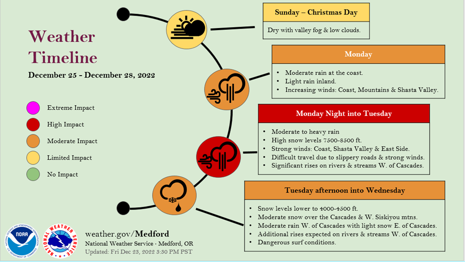
Incoming! Today will be the last day of unusually warm weather with mostly sunny skies and no precipitation forecasted. However, this will all change tomorrow. A river of atmospheric moisture is inbound from the Pacific. This will bring high winds, precipitation, and decreasing temperatures the first half of this week. Freezing levels are forecasted to drop over 5,500-7,000 feet between tonight and Tuesday.
The National Weather Service has issues a HIGH WIND WATCH for the town of Weed and the Shasta Valley immediately north of our forecast area. This will likely result in high winds above treeline on the big mountain. The NWS Medford office had the following quote in their forecast discussion this morning: "For the most part, the strongest winds will be along ridges [on Tuesday], roughly above 2500 feet. Winds in these areas are approaching the 90th percentile for strongest winds in climatology, which is when impacts such as downed tree limbs and downed weakened trees become more prevalent."
Source: NWS Medford
Today 7-8 Weather :
Partly sunny and unusually warm. Freezing level ~11,000'
Today 7-8 Wind Direction:
SSE
Today 8-9 Weather:
Mostly sunny and unusually warm.
Today 8-9 Wind Direction:
W
Tomorrow 7-8 Weather:
Rain/snow mix and windy. An incoming storm system. Freezing level ~9,500' dropping to ~7,000'
Tomorrow 7-8 Wind Direction:
S
Tomorrow 8-9 Weather:
Snow and strong winds.
Tomorrow 8-9 Wind Direction:
SW
Tonight 7-8 Weather:
Mostly cloudy and breezy. Freezing level ~11,000' dropping to ~9,500'
Tonight 7-8 Wind Direction:
S
Tonight 8-9 Weather:
Mostly cloudy and windy.
Tonight 8-9 Wind Direction:
SW
34
30
42
37
39
31.5
43
39.5
48.85
0
0.07
Grey Butte Temp Cur:
38.5
Grey Butte Temp Min:
29.5
Grey Butte Temp Max:
40.5
Grey Butte Temp Avg:
37.5
Grey Butte Wind Max:
25.5
Grey Butte Wind Gust Max:
49.07
Castle Lake Temp Cur:
46.5
Castle Lake Temp Min:
37.5
Castle Lake Temp Max:
53.5
Mount Eddy Temp Cur:
38.5
Mount Eddy Temp Max:
46.5
Mount Eddy Wind Gust Max:
3.83
Mount Eddy Snow Depth:
30.5
Ash Creek Bowl Temp Cur:
40.5
Ash Creek Bowl Temp Min:
32
Ash Creek Bowl Temp Max:
43
Ash Creek Bowl Temp Avg:
36
Ash Creek Bowl Snow New:
0
Ash Creek Ridge Temp Cur:
36.5
Ash Creek Ridge Temp Min:
36.5
Ash Creek Ridge Temp Max:
44
Ash Creek Ridge Temp Avg:
38
Ash Creek Ridge Wind Cur:
1.5
Ash Creek Ridge Wind Max:
20.5
Ash Creek Ridge Wind Gust Max:
30.94
Ash Creek Ridge Wind Avg:
SSW
Mt. Shasta City Temp Cur:
36
Mt. Shasta City Temp Min:
36
Mt. Shasta City Temp Max:
50
Mt. Shasta City Temp Avg:
41
Mt. Shasta City Wind Cur:
0
Mt. Shasta City Wind Min:
0
Mt. Shasta City Wind Max:
3
Mt. Shasta City Wind Avg:
0.5
Mt. Shasta City Wind Avg:
N
Grey Butte Wind Avg:
16.5
Ash Creek Ridge Wind Min:
1.5
Ash Creek Ridge Wind Avg:
10
Ski Bowl Snow Settlement:
2.6
Mount Eddy Snow Settlement:
1.1
Ash Creek Bowl Snow Settlement:
0.3
Measured Precipitation Oct:
5.99
Normal Precipitation Oct:
10.79
Percent Precipitation Oct:
56
Measured Precipitation MTD:
2.66
Normal Precipitation MTD:
5.16
Percent Precipitation MTD:
52
Measured Precipitation YTD:
13.94
Normal Precipitation YTD:
36.17
Percent Precipitation YTD:
39
Tomorrow Wind Max 7-9:
35
Tomorrow Wind Min 7-9:
25
Tonight Wind Max 9-11:
35
Tomorrow Wind Max 9-11:
40
Tonight Wind Min 9-11:
25
Tomorrow Wind Min 9-11:
30
Tonight Snow Max 7-9:
0.00
Tomorrow Snow Max 7-9:
3.00
Tonight Snow Min 7-9:
0.00
Tomorrow Snow Min 7-9:
1.00
Today Snow Max 9-11:
0.00
Tonight Snow Max 9-11:
0.00
Tomorrow Snow Max 9-11:
3.00
Today Snow Min 9-11:
0.00
Tonight Snow Min 9-11:
0.00
Tomorrow Snow Min 9-11:
1.00
Weather Station Discussion:
The table below summarizes data reported from all of our weather stations over the last 24 hours.
Seasonal Stats Discussion:
The wet season is October 1 through May 1. The table below summarizes recorded vs. normal precipitation amounts for the City of Mount Shasta.
Overall Danger Rating:
Low


