Submitted by mmadden on Sun, 12/04/2022 - 3:43am
Recent Observations:
The past 24 hours have seen a mix of weather from rain and wet snow to ice pellets, fog, and high winds. The Mount Shasta region is still continuing to build its winter snowpack with overall coverage shaping up nicely. Yesterday, forecasters found shallow buried obstacles near and below treeline that were easily struck without careful route-finding. The upper 45-65 cm (18-26 in) of the snowpack is generally soft, low density, and incohesive snow. This has meant that windy conditions the past 24 hours caused noticeable wind transport. HERE is a video of wind transporting snow below treeline yesterday in the area of Green Butte ridge. The wind slab problem remains a lingering possibility in specific areas, particularly near and above treeline and along ridge tops. Forecasters found areas of deep, wind-deposited snow yesterday but they lacked cohesive slab properties. No natural avalanches have been observed or reported and forecasters found wind-deposited test slopes unreactive.
Mountain Weather:
The WINTER WEATHER ADVISORY from yesterday's forecast is still in effect until 10 AM Monday (12/5) above 3,000 feet. The dynamic low pressure storm off the California coast will continue to push bands of precipitation into the Mount Shasta region today through Monday. Weather models show new snow totals of anywhere between 10-24 inches are possible by the end of tomorrow. This new snowfall will be short-lived as the low pressure storm is forecasted to move out of the area by Monday night. However, the main weather factor for today's forecast is wind. The Mount Shasta region can expect steady winds between 20-35 MPH. For those traveling near and above treeline, steady winds of 50-60 MPH can be expected, with gusts as high as 95 MPH forecasted for Lake Helen! These high winds could bring wind chills temperatures easily into negative double digits near and above treeline.
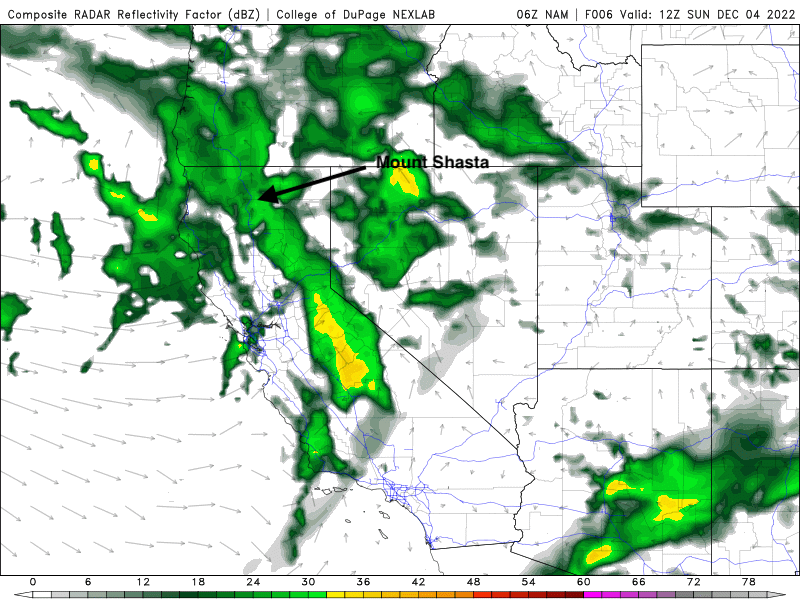
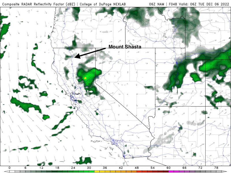
Weather models showing the low pressure storm moving past the Mount Shasta region by Monday night.
Source: NexGen Weather Lab, College of DuPage, NAM
Today 7-8 Weather :
Most cloudy and windy with gusts up to 40 MPH. Snow level at ~4,000'
Today 7-8 Wind Direction:
S
Today 8-9 Weather:
Snow showers and windy with gusts up to 95 MPH! Wind chill temperatures as low as -20°F.
Today 8-9 Wind Direction:
SW
Tomorrow 7-8 Weather:
Mostly cloudy with an 80% chance of new snow. Snow level at ~3,800'
Tomorrow 7-8 Wind Direction:
S
Tomorrow 8-9 Weather:
80% chance of snow showers with wind chill temperatures as low as -2°F
Tomorrow 8-9 Wind Direction:
SW
Tonight 7-8 Weather:
Cloudy with snow showers and 30-40 MPH wind gusts. Snow level at ~3,500'
Tonight 7-8 Wind Direction:
S
Tonight 8-9 Weather:
Cloudy and snow showers with wind chill temperatures as low as -16°F.
Tonight 8-9 Wind Direction:
SW
27
25
31
29
23.5
21.5
28.5
25.5
32.57
0.3
0.29
Grey Butte Temp Cur:
22.5
Grey Butte Temp Max:
27.5
Grey Butte Temp Avg:
24.5
Grey Butte Wind Max:
16.5
Grey Butte Wind Gust Max:
36.8
Castle Lake Temp Min:
24.5
Castle Lake Temp Avg:
28.5
Mount Eddy Temp Cur:
26.5
Mount Eddy Temp Min:
24.5
Mount Eddy Temp Avg:
27.5
Mount Eddy Wind Gust Max:
8.77
Mount Eddy Snow Depth:
28.57
Ash Creek Bowl Temp Cur:
25.5
Ash Creek Bowl Temp Min:
23
Ash Creek Bowl Temp Max:
29
Ash Creek Bowl Temp Avg:
26.5
Ash Creek Bowl Snow New:
2.1
Ash Creek Ridge Temp Cur:
21.5
Ash Creek Ridge Temp Min:
20
Ash Creek Ridge Temp Max:
26
Ash Creek Ridge Temp Avg:
23
Ash Creek Ridge Wind Cur:
0
Ash Creek Ridge Wind Max:
18
Ash Creek Ridge Wind Gust Max:
41.1
Mt. Shasta City Temp Cur:
35
Mt. Shasta City Temp Min:
35
Mt. Shasta City Temp Max:
38
Mt. Shasta City Temp Avg:
36
Mt. Shasta City Wind Cur:
0
Mt. Shasta City Wind Min:
0
Mt. Shasta City Wind Max:
10
Mt. Shasta City Wind Avg:
1.5
Mt. Shasta City Wind Avg:
N
Ash Creek Ridge Wind Min:
0
Ash Creek Ridge Wind Avg:
1
Ski Bowl Snow Settlement:
0
Mount Eddy Snow Settlement:
0.8
Ash Creek Bowl Snow Settlement:
0
Measured Precipitation Oct:
3.86
Normal Precipitation Oct:
6.25
Percent Precipitation Oct:
62
Measured Precipitation MTD:
0.53
Normal Precipitation MTD:
0.62
Percent Precipitation MTD:
85
Measured Precipitation YTD:
11.81
Normal Precipitation YTD:
31.63
Percent Precipitation YTD:
37
Tomorrow Wind Max 7-9:
15
Tonight Wind Max 9-11:
30
Tomorrow Wind Max 9-11:
20
Tonight Wind Min 9-11:
20
Tomorrow Wind Min 9-11:
10
Tonight Snow Max 7-9:
12.00
Tomorrow Snow Max 7-9:
5.00
Tonight Snow Min 7-9:
8.00
Tomorrow Snow Min 7-9:
3.00
Today Snow Max 9-11:
13.00
Tonight Snow Max 9-11:
14.00
Tomorrow Snow Max 9-11:
7.00
Today Snow Min 9-11:
9.00
Tonight Snow Min 9-11:
10.00
Tomorrow Snow Min 9-11:
3.00
Weather Station Discussion:
The table below summarizes data reported from all of our weather stations over the last 24 hours.
Seasonal Stats Discussion:
The wet season is October 1 through May 1. The table below summarizes recorded vs. normal precipitation amounts for the City of Mount Shasta.
Overall Danger Rating:
Moderate


