Submitted by sclairmont on Mon, 01/09/2023 - 5:23am
Recent Observations:
An avalanche observation was recorded yesterday from the Mount Eddy area. This was a north facing aspect, at 7,000 feet. The 3 foot crown was spotted as the party ascended a nearby ridgeline. This avalanche likely occurred within the last 24–36 hours. The failure plane was a thin layer of stellar dendrites that likely fell during the intermittent storm period of January 6 to January 7. The avalanche broke 3 feet deep, 400 feet wide and ran approximately 300 vertical feet into trees (HS-N-R3-D2.5-I).
This observation is important to note for all backcountry recreationalists. With the nonstop storm systems bearing down on the Mount Shasta region, it has been challenging to gain strong visual observations of avalanche occurrences in the mountains. This observation is a perfect example of what you can expect to find in similar aspects and elevations throughout the Mount Shasta region. This avalanche was definitely large enough to bury you. Avalanches of this type and size should be expected with the current instability combined with weather.
Yesterday's weather did not represent much of a lull in storm activity as forecasted. It was windy and snowy all day in the Eddies, with the occasional clearing of the skies. Snow was actively transporting to leeward slopes.
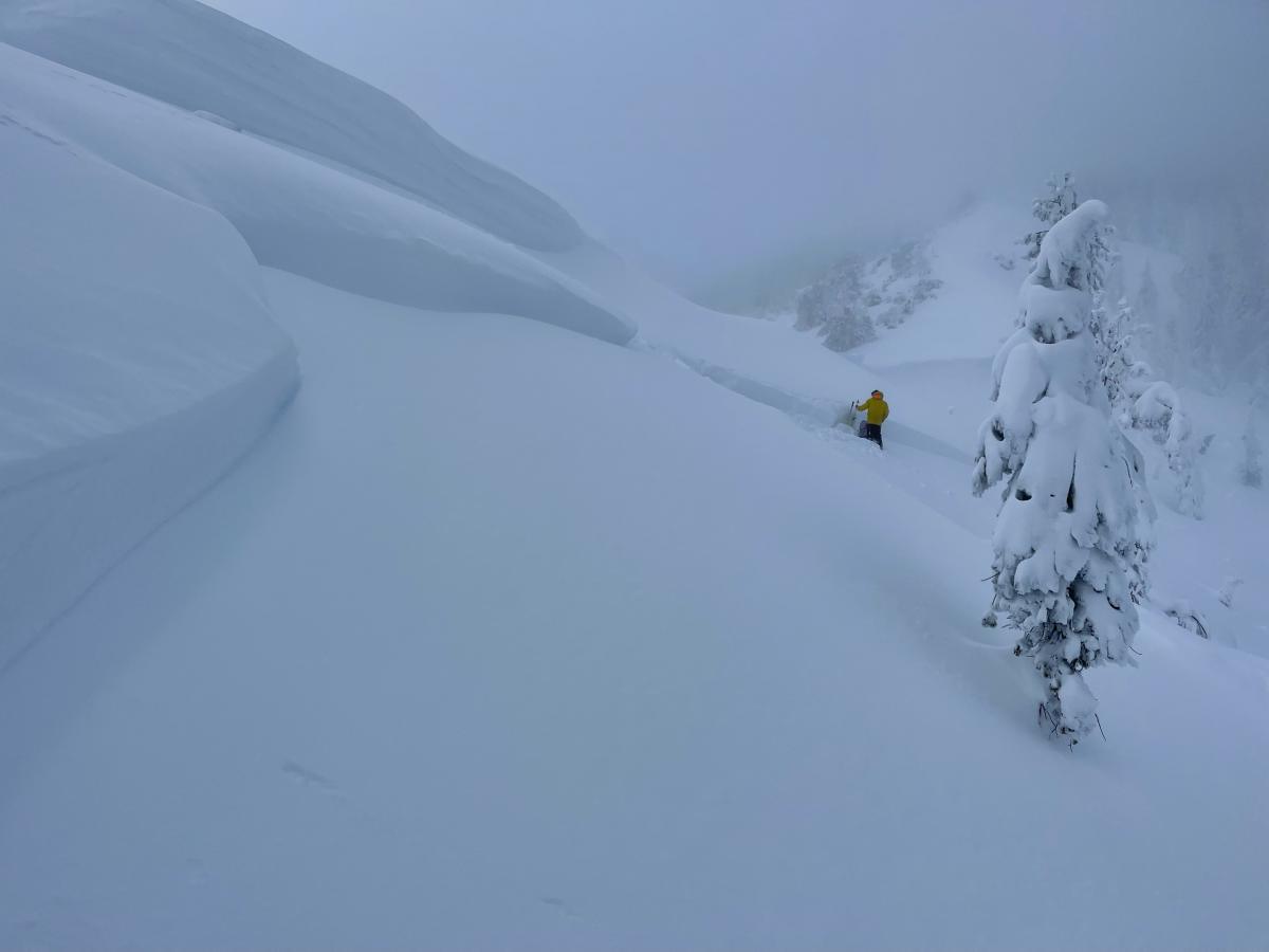
Photo: N. Meyers - Avalanche near Parks Creek Summit
Mountain Weather:
As they say in the show business, "the show must go on!" and that's the case here in Mount Shasta. It's wet and windy out there, and this will continue as storm systems develop in the pacific, heading our way. Late last night, a new surge of weather strengthened as a strong low pressure system closed in on the region. This morning, heavy rain and snow continues to impact the Siskiyou county. This precipitation will lighten up later in the day as this low makes its way north. With this new storm also came warmer temperatures. Snow levels are rising this morning to 5,000 feet.
The National Weather Service has issued a winter storm warning until 10am this morning. Expect blizzard like conditions above treeline as well as potentially difficult driving and travel conditions.
In the mountains, expect to see elevated winds and blowing snow. With these types of conditions, anticipate visibility to be very poor near and above treeline. Old Ski Bowl weather station recorded 9.3 inches of new snow (1.1 inches of SWE) in the last 24 hours. The last three hours have shown ~1.5 inches of snow per hour.
Winds have strengthened since yesterday afternoon. They will remain elevated through today, and slowly weaken this evening. Gray Butte (elevation of 8,100 feet, near treeline) has been showing consistent winds of 25-35 mph, with a gust of 42 mph at 2am this morning. With terrain near or above treeline, expect these winds to be much stronger. This higher elevation terrain could see gusts up to 70 mph.
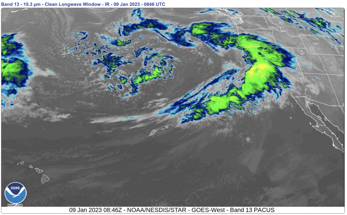
Radar provided by NWS. Time: 12:46am this morning.
Today 7-8 Weather :
Snow, heavy at times, lightening up after 10am. Temperatures dropping throughout the day. Snow level around rising to 5000 feet.
Today 7-8 Wind Direction:
SSE
Today 8-9 Weather:
Snow, mainly before 10am, then slight chance of snow showers in the afternoon. Snow could be heavy at times. Temperatures dropping in the late afternoon. Wind chill values as low as -19. Very windy, with gusts up to 70 mph.
Today 8-9 Wind Direction:
SSW
Tomorrow 7-8 Weather:
Snow, heavy at times. Snow level around 4300 feet.
Tomorrow 7-8 Wind Direction:
SSE
Tomorrow 8-9 Weather:
Snow, could be heavy at times. Windy, with winds slightly weakening in the afternoon. Gusts up to 55 mph. Wind chill values as low as -17.
Tomorrow 8-9 Wind Direction:
S
Tonight 7-8 Weather:
Mostly cloudy with a chance of snow. Snow level around 4400 feet.
Tonight 7-8 Wind Direction:
SSE
Tonight 8-9 Weather:
Chance of snow, mainly after 10pm. Mostly cloudy. Windy, with gusts up to 33 mph. Wind chill values as low as -12.
Tonight 8-9 Wind Direction:
S
27
26
28
27
83
14
0
26
21.5
26.5
24
127.3
8.6
1.07
Grey Butte Temp Cur:
24.5
Grey Butte Temp Min:
20.5
Grey Butte Wind Cur:
15.5
Grey Butte Wind Max:
19.5
Grey Butte Wind Gust Max:
42.93
Mount Eddy Temp Cur:
28.5
Mount Eddy Temp Min:
25.5
Mount Eddy Temp Avg:
27.5
Mount Eddy Wind Gust Max:
10.35
Mount Eddy Snow Depth:
97.5
Ash Creek Bowl Temp Cur:
25
Ash Creek Bowl Temp Min:
23
Ash Creek Bowl Temp Max:
25
Ash Creek Bowl Temp Avg:
23.5
Ash Creek Ridge Temp Cur:
23
Ash Creek Ridge Temp Min:
19.5
Ash Creek Ridge Temp Max:
23.5
Ash Creek Ridge Temp Avg:
21.5
Ash Creek Ridge Wind Cur:
0
Ash Creek Ridge Wind Max:
0
Ash Creek Ridge Wind Gust Max:
0
Mt. Shasta City Temp Cur:
38
Mt. Shasta City Temp Min:
33
Mt. Shasta City Temp Max:
40
Mt. Shasta City Temp Avg:
37.5
Mt. Shasta City Wind Cur:
7
Mt. Shasta City Wind Min:
0
Mt. Shasta City Wind Max:
7
Mt. Shasta City Wind Avg:
4
Mt. Shasta City Wind Avg:
ESE
Ash Creek Ridge Wind Min:
0
Ash Creek Ridge Wind Avg:
0
Sand Flat Snow Settlement:
0
Ski Bowl Snow Settlement:
0
Mount Eddy Snow Settlement:
0
Measured Precipitation Oct:
17.23
Normal Precipitation Oct:
13.96
Percent Precipitation Oct:
123
Measured Precipitation MTD:
8.1
Normal Precipitation MTD:
1.72
Percent Precipitation MTD:
471
Measured Precipitation YTD:
8.1
Normal Precipitation YTD:
1.72
Percent Precipitation YTD:
471
Tomorrow Wind Max 7-9:
50
Tomorrow Wind Min 7-9:
40
Tonight Wind Max 9-11:
30
Tomorrow Wind Max 9-11:
50
Tonight Wind Min 9-11:
20
Tomorrow Wind Min 9-11:
40
Tonight Snow Max 7-9:
5.00
Tomorrow Snow Max 7-9:
13.00
Tonight Snow Min 7-9:
3.00
Tomorrow Snow Min 7-9:
9.00
Today Snow Max 9-11:
12.00
Tonight Snow Max 9-11:
8.00
Tomorrow Snow Max 9-11:
18.00
Today Snow Min 9-11:
8.00
Tonight Snow Min 9-11:
4.00
Tomorrow Snow Min 9-11:
12.00
Weather Station Discussion:
The table below summarizes data reported from all of our weather stations over the last 24 hours.
Seasonal Stats Discussion:
The wet season is October 1 through May 1. The table below summarizes recorded vs. normal precipitation amounts for the City of Mount Shasta.
Overall Danger Rating:
High


