Submitted by nmeyers on Sat, 02/04/2023 - 5:38am
Recent Observations:
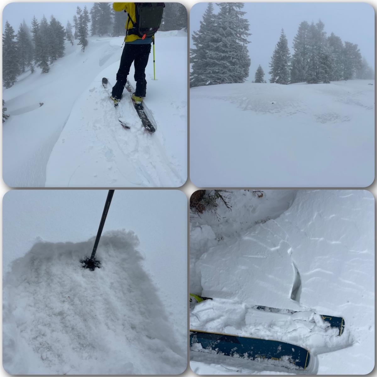
Over the past 24 hours, the mountains of southern Siskiyou County have received 2–4 inches of new snow. Southwest wind has been predominant, averaging 11 mi/hr with gusts to 43 mi/hr. Temperatures have averaged 23 degrees. Yesterday on Green Butte Ridge, it was a chilly day with poor visibility above treeline, light snow and moderate, gusty SE-S-SW wind. New snow distribution was uneven, with southerly wind blowing snow onto westerly and northerly aspects. Along Green Butte Ridge, the W-NW side of the ridge had better coverage than the windward SE-E side. Small wind slabs up to one foot thick could be found around tree wells and other leeward terrain features. Conditions were a level above dust on crust…we'll call it fluff on crust. Wind exposed areas were scoured down to the old, icy surface. Crazy amounts of tree debris litter the snowpack. It will take a foot or more of new snow to bury the detritus completely. Until then, watch out for sharp wooden objects. On the down, ski edges found chunky, icy surfaces below the fresh snow.
Mountain Weather:
A front in the eastern Pacific will move over the west coast today and tonight, tracking southeastward. Today, the system will produce coastal rain and higher-elevation snow over northern California and the Pacific Northwest. Showers have dissipated overnight, but the dry weather won't last long; the next system is close behind. Expect another period of breezy winds ahead of the storm. Precipitation will be more widespread and with greater amounts than the previous storm. Showery conditions will linger Sunday. Snow levels are fairly high with this event due to southerly flow bringing in warmer air to the region...they will hover around 5,000 feet this afternoon/evening, lowering to 3,500 feet as colder air moves in tonight.
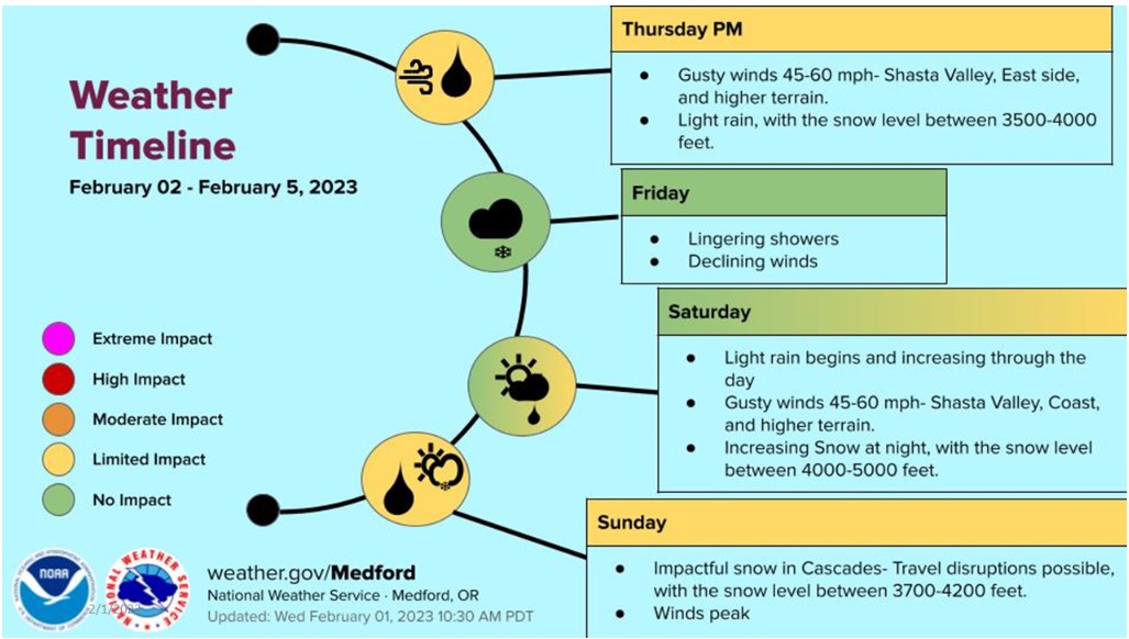
Today 7-8 Weather :
Snow, mainly after 4pm, heavy at times, breezy. Snow level near 5,100 feet
Today 7-8 Wind Direction:
S
Today 8-9 Weather:
Snow, mainly after 4pm, heavy at times, windy
Today 8-9 Wind Direction:
S
Tomorrow 7-8 Weather:
Snow showers mainly between 10am and 4pm, mostly cloudy. Snow level near 3,900 feet
Tomorrow 7-8 Wind Direction:
SW
Tomorrow 8-9 Weather:
Snow showers, mainly between 10am and 4pm, mostly cloudy, breezy
Tomorrow 8-9 Wind Direction:
W
Tonight 7-8 Weather:
Snow showers, heavy at times, breezy. Snow level near 4,900 feet
Tonight 7-8 Wind Direction:
S
Tonight 8-9 Weather:
Snow showers, heavy at times, windy
Tonight 8-9 Wind Direction:
S
27
23
29
27
101
3
0
23.5
19.5
25
22.5
127.9
3.4
0
Grey Butte Temp Cur:
23.5
Grey Butte Temp Min:
18.5
Grey Butte Temp Max:
23.5
Grey Butte Temp Avg:
21.5
Grey Butte Wind Max:
18.5
Grey Butte Wind Gust Max:
42.93
Castle Lake Temp Min:
24.5
Castle Lake Temp Avg:
28.5
Mount Eddy Temp Cur:
26.5
Mount Eddy Temp Avg:
26.5
Mount Eddy Wind Gust Max:
8.26
Mount Eddy Snow Depth:
103.2
Ash Creek Bowl Temp Cur:
25.5
Ash Creek Bowl Temp Min:
21.5
Ash Creek Bowl Temp Max:
25.5
Ash Creek Bowl Temp Avg:
24
Ash Creek Bowl Snow New:
2.6
Ash Creek Ridge Temp Cur:
22.5
Ash Creek Ridge Temp Min:
18.5
Ash Creek Ridge Temp Max:
22.5
Ash Creek Ridge Temp Avg:
21
Ash Creek Ridge Wind Cur:
0
Ash Creek Ridge Wind Max:
33
Ash Creek Ridge Wind Gust Max:
57
Mt. Shasta City Temp Cur:
38
Mt. Shasta City Temp Min:
33
Mt. Shasta City Temp Max:
40
Mt. Shasta City Temp Avg:
37
Mt. Shasta City Wind Cur:
0
Mt. Shasta City Wind Min:
0
Mt. Shasta City Wind Max:
7
Mt. Shasta City Wind Avg:
3.5
Mt. Shasta City Wind Avg:
ESE
Ash Creek Ridge Wind Min:
0
Ash Creek Ridge Wind Avg:
6
Sand Flat Snow Settlement:
0
Ski Bowl Snow Settlement:
0
Mount Eddy Snow Settlement:
0
Ash Creek Bowl Snow Settlement:
0
Measured Precipitation Oct:
26.16
Normal Precipitation Oct:
19.1
Percent Precipitation Oct:
137
Measured Precipitation MTD:
0.28
Normal Precipitation MTD:
0.57
Percent Precipitation MTD:
49
Measured Precipitation YTD:
17.03
Normal Precipitation YTD:
6.86
Percent Precipitation YTD:
248
Tomorrow Wind Max 7-9:
15
Tonight Wind Max 9-11:
40
Tomorrow Wind Max 9-11:
25
Tonight Wind Min 9-11:
30
Tomorrow Wind Min 9-11:
15
Tonight Snow Max 7-9:
10.00
Tomorrow Snow Max 7-9:
2.00
Tonight Snow Min 7-9:
6.00
Tomorrow Snow Min 7-9:
1.00
Today Snow Max 9-11:
5.00
Tonight Snow Max 9-11:
12.00
Tomorrow Snow Max 9-11:
3.00
Today Snow Min 9-11:
3.00
Tonight Snow Min 9-11:
8.00
Tomorrow Snow Min 9-11:
2.00
Weather Station Discussion:
The table below summarizes data reported from all of our weather stations over the last 24 hours.
Seasonal Stats Discussion:
The wet season is October 1 through May 1. The table below summarizes recorded vs. normal precipitation amounts for the City of Mount Shasta.
Overall Danger Rating:
Moderate


