Submitted by sclairmont on Mon, 02/27/2023 - 5:04am
Recent Observations:
In the last 24 hours, winter weather continued on Mount Shasta, bringing new snow and elevated westerly winds. Around six inches of low density snow fell yesterday through last night, with more at upper elevations. The obscured conditions kept mountain temperatures low in the teens through the day. Winds remained moderate, with strong gusts out of the west.
Yesterday's observations came from the Gray Butte area. The February 24th snow has continued settling, becoming slightly more supportable on skis. Moderate snow and graupel rates were encountered throughout the day, with increased intensity at higher elevation. Winds were actively transporting snow onto leeward aspects, blowing snow was evident. A thin melt freeze surface crust had formed overnight with the cooling temperatures. The surface crust is thicker on solar aspects. Four inches of low density new snow was found on the surface crust. No signs of snowpack instability or avalanches were observed, However, the new snow showed no signs of bonding to the firm melt freeze crust underneath on solar aspects.
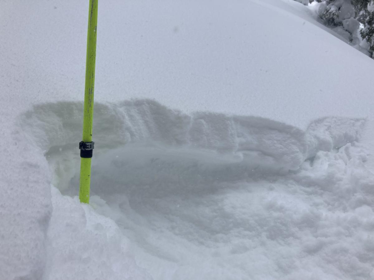
Image: A few inches of new snow on the old surface crust. Amount of new snow varies on exposure and elevation. S. Clairmont
Mountain Weather:
A substantial frontal system will arrive this morning, bringing winter weather to the Mount Shasta region. A winter storm warning is in effect for much of Siskiyou county. This storm will bring southwest flow, similar to the storm event on February 24th. A period of very heavy snowfall is expected for Mount Shasta this morning until noon. Rates could be one to two inches of snow per hour in town. Expect substantially more at higher elevations on the mountain. Snow levels will drop to as low as 500 feet this morning. Snow showers will linger for the remainder of the day, with snow levels rising to 1,500 feet. Tonight, snow will return with the coldest temps of the system. Strong winds will accompany this front, with speeds well into the strong (26-38 mph) and extreme (>38 mph) categories near and above treeline. Expect widespread blowing snow, poor visibility, and extremely low wind chill values. More snow is expected into Tuesday.
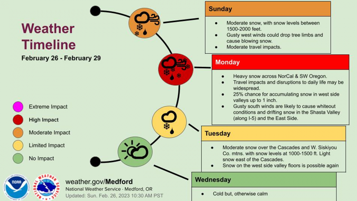
Image: NWS Medford
Today 7-8 Weather :
Snow showers. Widespread blowing snow. Windy, with gusts as high as 55 mph.
Today 7-8 Wind Direction:
S
Today 8-9 Weather:
Snow showers. Widespread blowing snow. Wind chill values as low as -34 F. Gusts up to 115 mph.
Today 8-9 Wind Direction:
SW
Tomorrow 7-8 Weather:
Snow showers, mainly after 4pm. Widespread blowing snow. Gusts up to 31 mph.
Tomorrow 7-8 Wind Direction:
S
Tomorrow 8-9 Weather:
Snow showers, mainly after 4pm. Widespread blowing snow. Wind chill values as low as -31 F. Gusts up to 55 mph.
Tomorrow 8-9 Wind Direction:
SW
Tonight 7-8 Weather:
Snow showers. Blowing snow. Gusts as high as 30 mph.
Tonight 7-8 Wind Direction:
SW
Tonight 8-9 Weather:
Snow showers. Widespread blowing snow. Wind chill values as low as -35 F. Gusts as high as 70 mph.
Tonight 8-9 Wind Direction:
W
14
14
25
20
117
0
0
10
10
20
15
138.3
0
0
Grey Butte Wind Cur:
12.5
Grey Butte Wind Max:
18.5
Grey Butte Wind Gust Max:
49.07
Mount Eddy Temp Cur:
13.5
Mount Eddy Temp Min:
12.5
Mount Eddy Temp Avg:
19.5
Mount Eddy Wind Gust Max:
5.87
Mount Eddy Snow Depth:
127.6
Ash Creek Bowl Temp Cur:
13
Ash Creek Bowl Temp Min:
13
Ash Creek Bowl Temp Max:
20
Ash Creek Bowl Temp Avg:
17
Ash Creek Bowl Snow New:
0.2
Ash Creek Ridge Temp Cur:
8
Ash Creek Ridge Temp Min:
8
Ash Creek Ridge Temp Max:
16
Ash Creek Ridge Temp Avg:
13
Ash Creek Ridge Wind Cur:
0
Ash Creek Ridge Wind Max:
14.5
Ash Creek Ridge Wind Gust Max:
31.05
Mt. Shasta City Temp Cur:
29
Mt. Shasta City Temp Min:
28
Mt. Shasta City Temp Max:
36
Mt. Shasta City Temp Avg:
32
Mt. Shasta City Wind Cur:
4
Mt. Shasta City Wind Min:
0
Mt. Shasta City Wind Max:
5
Mt. Shasta City Wind Avg:
2.5
Mt. Shasta City Wind Avg:
N
Ash Creek Ridge Wind Min:
0
Ash Creek Ridge Wind Avg:
0.5
Sand Flat Snow Settlement:
1
Ski Bowl Snow Settlement:
5.1
Mount Eddy Snow Settlement:
0
Ash Creek Bowl Snow Settlement:
0
Measured Precipitation Oct:
28.59
Normal Precipitation Oct:
24.47
Percent Precipitation Oct:
117
Measured Precipitation MTD:
2.71
Normal Precipitation MTD:
5.94
Percent Precipitation MTD:
46
Measured Precipitation YTD:
19.46
Normal Precipitation YTD:
12.23
Percent Precipitation YTD:
159
Tomorrow Wind Max 7-9:
25
Tomorrow Wind Min 7-9:
15
Tonight Wind Max 9-11:
45
Tomorrow Wind Max 9-11:
35
Tonight Wind Min 9-11:
35
Tomorrow Wind Min 9-11:
25
Today Snow Max 7-9:
16.00
Tonight Snow Max 7-9:
8.00
Tomorrow Snow Max 7-9:
8.00
Today Snow Min 7-9:
10.00
Tonight Snow Min 7-9:
3.00
Tomorrow Snow Min 7-9:
3.00
Today Snow Max 9-11:
16.00
Tonight Snow Max 9-11:
8.00
Tomorrow Snow Max 9-11:
8.00
Today Snow Min 9-11:
10.00
Tonight Snow Min 9-11:
3.00
Tomorrow Snow Min 9-11:
3.00
Weather Station Discussion:
The table below summarizes data reported from all of our weather stations over the last 24 hours.
Seasonal Stats Discussion:
The wet season is October 1 through May 1. The table below summarizes recorded vs. normal precipitation amounts for the City of Mount Shasta.
Overall Danger Rating:
Moderate


