Submitted by nmeyers on Fri, 03/03/2023 - 5:16am
Recent Observations:
A handful of local shredders have been getting after it this week, with no reports of snow behaving badly. We had one user submitted photo of a small storm slab near treeline on the west face of Gray Butte. Other than that, the two feet of recent storm snow has been settling nicely. As a cohort of mine said, "Never underestimate the ability of a massive dump to do absolutely... nothing." What is possible during big storms can go either way: a big avalanche, or none at all. So it goes. Avalanche center staff has been poking our noses in many zones around the forecast area and have not observed any lingering weak layers or signs of danger. The past two days, warmer temps and the good old California sun gave the new snow a solid bake. Temperatures over the past 24 hours have averaged 28° degrees, with a max of 39° and low of 15° near treeline on Mount Shasta. Wind has blown predominantly out of the northwest, averaging 16 mi/hr with gusts to 49 mi/hr. Last night, a dusting of new snow fell. Snow surfaces will get a more robust refresh this weekend, but for today, expect Shasta variable...the post storm, sun baked, wind affected, crust, powder smorgasbord.
Mountain Weather:
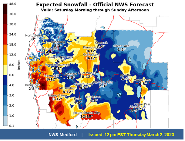
Rain and additional heavy mountain snow will return to the West Coast on Saturday. A storm system tracking southward across the Pacific Northwest and California on Saturday will produce moderate to heavy precipitation across coastal portions of the region, with heavy snow possible in the higher terrains of the Sierra Nevada and Cascade ranges. An additional several feet of snow will be possible in these areas. A winter storm warning remains in effect from 4am Saturday to 4pm PST Sunday. The main event arrives at our doorstep tonight and continues into the weekend, bringing another round of significant winter weather impacts. Snow levels will be as low as 500 feet on Saturday morning. This event is similar from the one we just went through. Longer term, there are signs of a major pattern shift toward milder weather in the latter half of next week as the low lifts out and ridging develops.
Today 7-8 Weather :
Partly cloudy this morning then becoming mostly cloudy
Today 7-8 Wind Direction:
NW
Today 8-9 Weather:
Partly sunny, windy
Today 8-9 Wind Direction:
NW
Tomorrow 7-8 Weather:
Breezy. Snow and blowing snow. Snow level near 500 feet
Tomorrow 7-8 Wind Direction:
S
Tomorrow 8-9 Weather:
Snow, heavy at times. Widespread blowing snow. Windy. New snow accumulation of 6 to 10 inches
Tomorrow 8-9 Wind Direction:
SW
Tonight 7-8 Weather:
Breezy, mostly cloudy, 30% chance of snow. Snow level near 3,000 feet and lowering
Tonight 7-8 Wind Direction:
SW
Tonight 8-9 Weather:
A 30% chance of snow after 10pm. Mostly cloudy, windy. New snow accumulation of 2 to 4 inches
Tonight 8-9 Wind Direction:
SW
19
15
37
29
120
0
0
24
15
39
28.5
152.9
0
0
Grey Butte Temp Min:
15.5
Grey Butte Temp Avg:
26.5
Grey Butte Wind Cur:
18.5
Grey Butte Wind Max:
26.5
Grey Butte Wind Gust Max:
49.07
Castle Lake Temp Cur:
23.5
Castle Lake Temp Min:
18.5
Castle Lake Temp Max:
44.5
Mount Eddy Temp Cur:
17.5
Mount Eddy Temp Min:
17.5
Mount Eddy Temp Avg:
29.5
Mount Eddy Wind Gust Max:
6.02
Mount Eddy Snow Depth:
132.2
Ash Creek Bowl Temp Cur:
17
Ash Creek Bowl Temp Min:
17
Ash Creek Bowl Temp Max:
34
Ash Creek Bowl Temp Avg:
26
Ash Creek Bowl Snow New:
0
Ash Creek Ridge Temp Cur:
12.5
Ash Creek Ridge Temp Min:
12.5
Ash Creek Ridge Temp Max:
29.5
Ash Creek Ridge Temp Avg:
22.5
Ash Creek Ridge Wind Cur:
0
Ash Creek Ridge Wind Max:
0
Ash Creek Ridge Wind Gust Max:
0
Mt. Shasta City Temp Cur:
31
Mt. Shasta City Temp Min:
21
Mt. Shasta City Temp Max:
45
Mt. Shasta City Temp Avg:
35
Mt. Shasta City Wind Cur:
0
Mt. Shasta City Wind Min:
0
Mt. Shasta City Wind Max:
6
Mt. Shasta City Wind Avg:
2
Grey Butte Wind Avg:
15.5
Ash Creek Ridge Wind Min:
0
Ash Creek Ridge Wind Avg:
0
Sand Flat Snow Settlement:
4
Ski Bowl Snow Settlement:
3.2
Mount Eddy Snow Settlement:
4.7
Ash Creek Bowl Snow Settlement:
2.2
Measured Precipitation Oct:
29.72
Normal Precipitation Oct:
25.4
Percent Precipitation Oct:
117
Measured Precipitation MTD:
0.01
Normal Precipitation MTD:
0.46
Percent Precipitation MTD:
2
Measured Precipitation YTD:
20.59
Normal Precipitation YTD:
13.16
Percent Precipitation YTD:
156
Tomorrow Wind Max 7-9:
20
Tomorrow Wind Min 7-9:
10
Tonight Wind Max 9-11:
35
Tomorrow Wind Max 9-11:
45
Tonight Wind Min 9-11:
25
Tomorrow Wind Min 9-11:
35
Tonight Snow Max 7-9:
3.00
Tomorrow Snow Max 7-9:
9.00
Tonight Snow Min 7-9:
1.00
Tomorrow Snow Min 7-9:
5.00
Today Snow Max 9-11:
0.00
Tonight Snow Max 9-11:
4.00
Tomorrow Snow Max 9-11:
10.00
Today Snow Min 9-11:
0.00
Tonight Snow Min 9-11:
2.00
Tomorrow Snow Min 9-11:
6.00
Weather Station Discussion:
The table below summarizes data reported from all of our weather stations over the last 24 hours.
Seasonal Stats Discussion:
The wet season is October 1 through May 1. The table below summarizes recorded vs. normal precipitation amounts for the City of Mount Shasta.
Overall Danger Rating:
Low


