Submitted by sclairmont on Sun, 03/05/2023 - 5:04am
Recent Observations:
In the last 24 hours, southerly flow brought 18 inches of new snow at treeline. Winds remained out of the west, turning more southerly last night. Temperatures remained quite cold, around 10 degrees F at 8,000 feet last night. The sun made a short appearance yesterday afternoon in a lull between showers.
Yesterday's observations come from Green Butte Ridge area where instability could be found abundantly. Strong winds, moderate to high snow accumulation rates, cracking, and triggering of storm slab avalanches were all prevalent. These red flags were found below, near, and above treeline. Moderate to high accumulation rates put six to seven inches of new snow on the ground in five hours. Numerous storm slab avalanches were intentionally triggered on test slopes with W-S-E aspects. These avalanches slid on the new snow old snow interface. The old snow presented with a firm but punchable surface crust to which the new slow could easily slide.
Another observation came from the Eddy mountains, where stiff west winds were actively transporting snow onto leeward slopes. Touchy conditions resulted in multiple wind slab avalanches found throughout the day. New snow totals midday varied upon aspect and terrain feature, with some areas showing upwards of a foot.
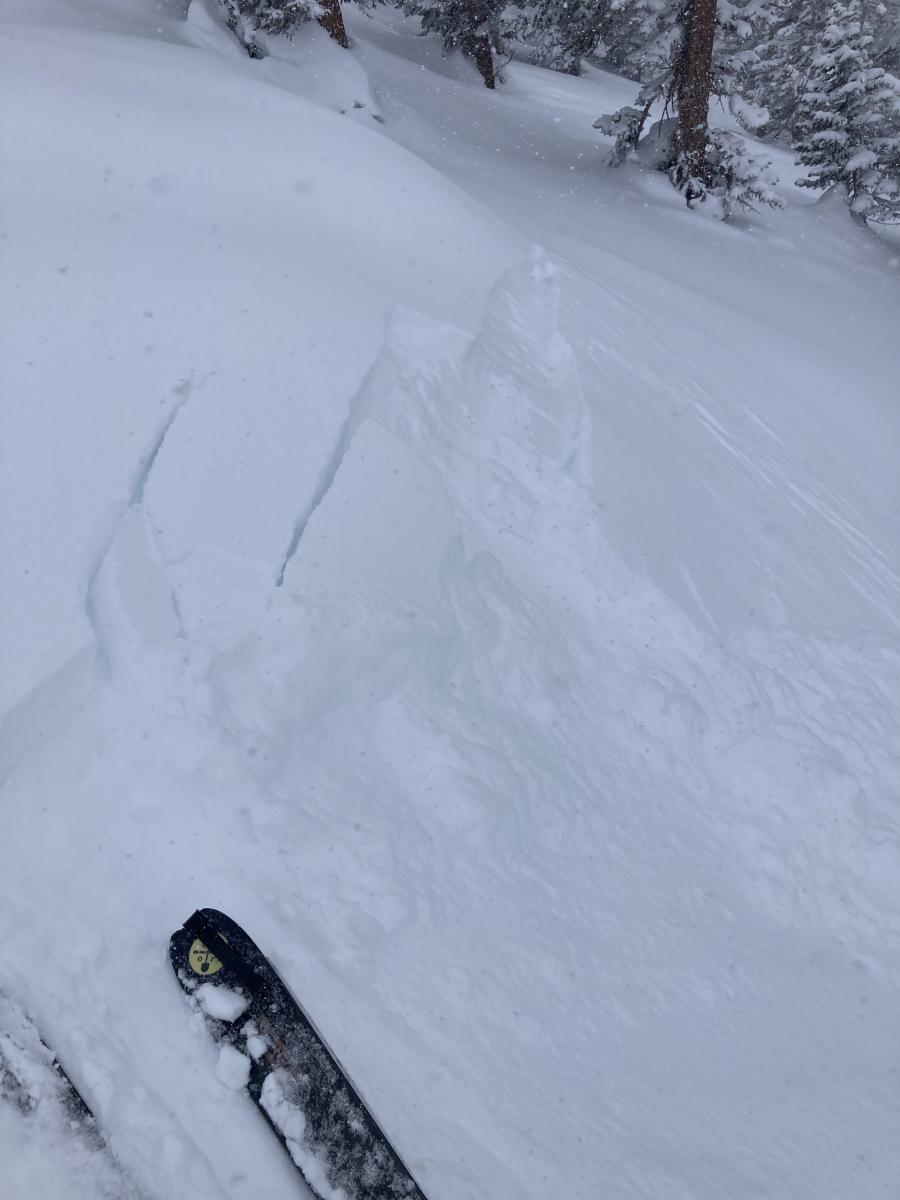
Photo: Storm slab avalanche near treeline. S. Clairmont
Mountain Weather:
An upper level trough positioned just offshore of Oregon will continue to send showery precipitation to Siskiyou county for at least the next 24 hours. A winter storm warning is in place for the Mount Shasta region. After a brief pause in snow yesterday afternoon, more snow has fallen overnight on Mount Shasta. As of 6 am, weather stations are reporting around 18 inches of new snow in the last 24 hours. Notably, Old Ski Bowl weather station recorded snowfall rates of around two inches per hour since midnight. High precipitation rates will likely continue into this afternoon due to the southerly flow of this system. Snow intensity will taper off later in the day into the evening. Monday will see another round of new snow, albeit weaker than today. Snow levels will remain very low (~500 feet) through today into tomorrow. Temperatures will remain cold. This system has brought notably less wind than recent storms, remaining moderate with strong gusts out of the southwest below, near, and above treeline. Expect winds to strengthen significantly at elevations above 10,000 feet.
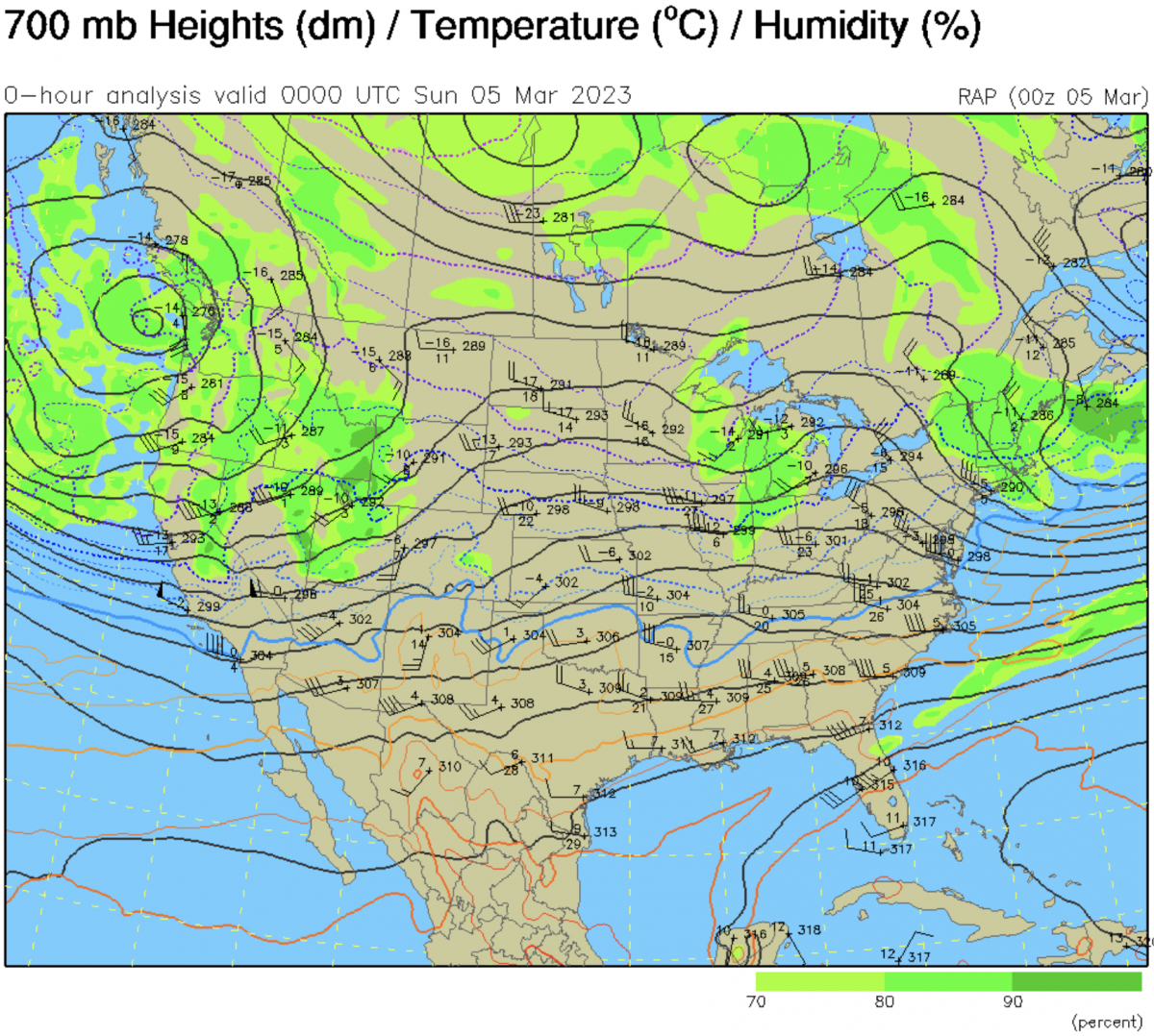
Image: A 10,000 foot analysis of the system bringing southwest flow to the Mount Shasta region.
Today 7-8 Weather :
Snow showers. Snow could be heavy at times. Widespread blowing snow. gusts up to 40 mph. Snow level will be at the base
Today 7-8 Wind Direction:
SW
Today 8-9 Weather:
Snow showers. Snow could be heavy at times. Widespread blowing snow. Gusts up to 55 mph. Wind chill as low as -31 F
Today 8-9 Wind Direction:
NW
Tomorrow 7-8 Weather:
Snow showers. Gusts up to 30 mph. Snow level will be at the base
Tomorrow 7-8 Wind Direction:
S
Tomorrow 8-9 Weather:
Snow showers. Gusts up to 48 mph. Wind chill as low as -28 F
Tomorrow 8-9 Wind Direction:
SW
Tonight 7-8 Weather:
Snow showers. Gusts up to 24 mph. Snow level will be at the base
Tonight 7-8 Wind Direction:
S
Tonight 8-9 Weather:
Snow showers. Widespread blowing snow. Gusts up to 70 mph. Wind chill as low as -29 F
Tonight 8-9 Wind Direction:
SW
17
16
23
19
132
14
0
12.5
11.5
19
14
167.8
17.2
0
Grey Butte Temp Cur:
11.5
Grey Butte Temp Min:
10.5
Grey Butte Wind Cur:
14.5
Grey Butte Wind Max:
20.5
Grey Butte Wind Gust Max:
42.93
Castle Lake Temp Min:
18.5
Mount Eddy Temp Max:
21.5
Mount Eddy Wind Gust Max:
6.05
Mount Eddy Snow Depth:
145.5
Mount Eddy Snow New:
16.1
Ash Creek Bowl Temp Cur:
14
Ash Creek Bowl Temp Min:
13.5
Ash Creek Bowl Temp Max:
22.5
Ash Creek Bowl Temp Avg:
15.5
Ash Creek Bowl Snow New:
15
Ash Creek Ridge Temp Cur:
10.5
Ash Creek Ridge Temp Min:
10
Ash Creek Ridge Temp Max:
16.5
Ash Creek Ridge Temp Avg:
12
Ash Creek Ridge Wind Cur:
0
Ash Creek Ridge Wind Max:
29
Ash Creek Ridge Wind Gust Max:
118.69
Mt. Shasta City Temp Cur:
27
Mt. Shasta City Temp Min:
27
Mt. Shasta City Temp Max:
36
Mt. Shasta City Temp Avg:
30.5
Mt. Shasta City Wind Cur:
4
Mt. Shasta City Wind Min:
0
Mt. Shasta City Wind Max:
5
Mt. Shasta City Wind Avg:
2
Mt. Shasta City Wind Avg:
N
Grey Butte Wind Avg:
11.5
Ash Creek Ridge Wind Min:
0
Ash Creek Ridge Wind Avg:
7.5
Sand Flat Snow Settlement:
0
Ski Bowl Snow Settlement:
0
Mount Eddy Snow Settlement:
0
Ash Creek Bowl Snow Settlement:
0
Measured Precipitation Oct:
30.24
Normal Precipitation Oct:
25.82
Percent Precipitation Oct:
117
Measured Precipitation MTD:
0.53
Normal Precipitation MTD:
0.88
Percent Precipitation MTD:
60
Measured Precipitation YTD:
21.11
Normal Precipitation YTD:
13.58
Percent Precipitation YTD:
155
Tomorrow Wind Max 7-9:
20
Tomorrow Wind Min 7-9:
10
Tonight Wind Max 9-11:
30
Tomorrow Wind Max 9-11:
35
Tonight Wind Min 9-11:
20
Tomorrow Wind Min 9-11:
25
Tonight Snow Max 7-9:
5.00
Tomorrow Snow Max 7-9:
4.00
Tonight Snow Min 7-9:
3.00
Tomorrow Snow Min 7-9:
2.00
Today Snow Max 9-11:
10.00
Tonight Snow Max 9-11:
4.00
Tomorrow Snow Max 9-11:
3.00
Today Snow Min 9-11:
6.00
Tonight Snow Min 9-11:
2.00
Tomorrow Snow Min 9-11:
1.00
Weather Station Discussion:
The table below summarizes data reported from all of our weather stations over the last 24 hours.
Seasonal Stats Discussion:
The wet season is October 1 through May 1. The table below summarizes recorded vs. normal precipitation amounts for the City of Mount Shasta.
Overall Danger Rating:
High


