Submitted by sclairmont on Mon, 03/06/2023 - 5:02am
Recent Observations:
In the last 24 hours, southerly flow brought 4 inches of new snow at treeline. Winds remained light to moderate out of the west. Temperatures remained quite cold, around 9 degrees F at 8,000 feet last night. The sun popped out for short periods of time across the forecast area.
Yesterday's observations come from the northwest face of the Gray Butte area. Around 19 inches (50 cm) of new snow was measured at 7,600 feet. The most notable observations were the screaming signs of instability. On the ski down, virtually any open slope close to 30 degrees would shoot cracks and settle without enough angle to slide. Avalanche debris could be seen buried underneath fresh snow below the chutes of the northwest face. A pit dug at 7,600 feet (NW aspect) showed a right side up snowpack, with 3 feet of dense consolidated snow beneath last night's new snow. Upon tests, an ECTP was observed on tap 13. The failure plane was 14 inches down within the 19 inches of new snow. A thin 4-5mm graupel layer that fell in between storms on March 4th was the weak layer.
Another party in the Eddy mountains reported off and on precipitation, westerly winds transporting snow onto leeward aspects, and some warming of the surface snow from extended periods of sun.
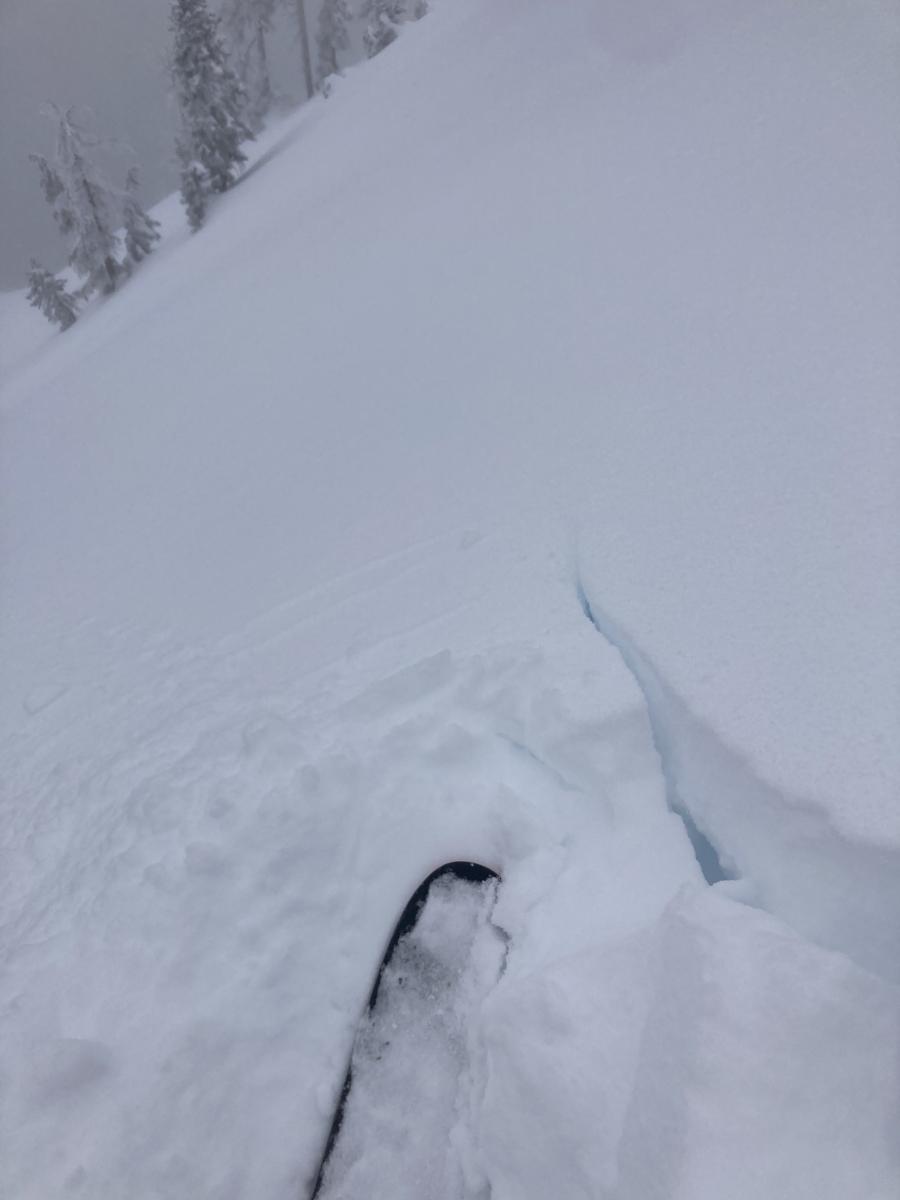
Photo: Shooting cracks. S. Clairmont
Mountain Weather:
A deep and cold low pressure system will remain positioned off the Oregon coast today. A deep trough from this low is currently dipping down to Northern California, continuing the southwest flow over Mount Shasta for the next 24 hours. Scattered showers will pass over Siskiyou county, with snow expected into tonight. Around four to six inches of snow is expected in the next 24 hours. Cold temperatures will continue, with cloud cover remaining over the area. Winds will remain light to moderate out of the south. A winter storm warning has been issued for the Mount Shasta area from 4am Tuesday until 10am Wednesday in preparation for a stronger low pressure. Farther out, another deep low is expected on Thursday.
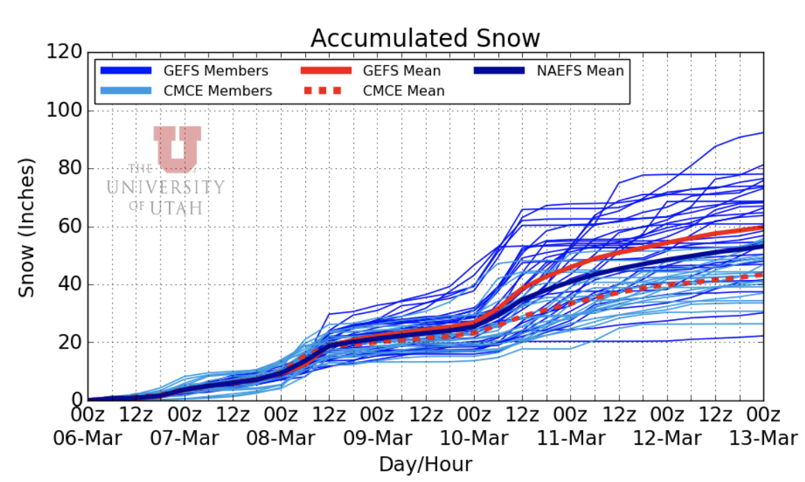
Image: University of Utah's NAEFS snow forecast for the Mount Shasta region. This shows some large ambiguity on the long term, but safe to say more snow is on the way.
Today 7-8 Weather :
Snow showers likely, mainly after 10am. Gusts as high as 23 mph. Snow level will be at the base
Today 7-8 Wind Direction:
S
Today 8-9 Weather:
Snow showers likely, mainly after 10am. Mostly cloudy and cold. Wind chill values as low as -28 F. Gusts up to 28 mph
Today 8-9 Wind Direction:
S
Tomorrow 7-8 Weather:
Snow showers, mainly after 10am. Snow could be heavy at times. Gusts up to 26 mph. Snow level will be at the base
Tomorrow 7-8 Wind Direction:
S
Tomorrow 8-9 Weather:
Snow showers, mainly after 10 am. Snow could be heavy at times. Wind chill values as low as -22 F. Breezy, with gusts up to 34 mph
Tomorrow 8-9 Wind Direction:
S
Tonight 7-8 Weather:
Snow showers likely, mainly after 10pm. Mostly cloudy. Wind around 11mph. Snow level will be at the base
Tonight 7-8 Wind Direction:
S
Tonight 8-9 Weather:
Snow showers likely, mainly after 10pm. Mostly cloudy. Wind chill values as low as -19 F. Gusts up to 21 mph
Tonight 8-9 Wind Direction:
SW
16
12
27
18
130
0
0
11.5
9
21.5
13.5
167
1
0
Grey Butte Temp Max:
22.5
Grey Butte Wind Max:
16.5
Grey Butte Wind Gust Max:
42.93
Castle Lake Temp Cur:
20.5
Castle Lake Temp Max:
36.5
Castle Lake Temp Avg:
22.5
Mount Eddy Temp Avg:
16.5
Mount Eddy Wind Gust Max:
4.75
Mount Eddy Snow Depth:
142.9
Ash Creek Bowl Temp Cur:
12.5
Ash Creek Bowl Temp Min:
10.5
Ash Creek Bowl Temp Max:
19
Ash Creek Bowl Temp Avg:
14.5
Ash Creek Bowl Snow New:
0.3
Ash Creek Ridge Temp Cur:
9
Ash Creek Ridge Temp Min:
8.5
Ash Creek Ridge Temp Max:
18.5
Ash Creek Ridge Temp Avg:
11
Ash Creek Ridge Wind Cur:
0
Ash Creek Ridge Wind Max:
0
Ash Creek Ridge Wind Gust Max:
0
Mt. Shasta City Temp Cur:
27
Mt. Shasta City Temp Min:
25
Mt. Shasta City Temp Max:
35
Mt. Shasta City Temp Avg:
29.5
Mt. Shasta City Wind Cur:
3
Mt. Shasta City Wind Min:
0
Mt. Shasta City Wind Max:
5
Mt. Shasta City Wind Avg:
1.5
Mt. Shasta City Wind Avg:
N
Ash Creek Ridge Wind Min:
0
Ash Creek Ridge Wind Avg:
0
Sand Flat Snow Settlement:
3
Ski Bowl Snow Settlement:
0
Mount Eddy Snow Settlement:
2.8
Ash Creek Bowl Snow Settlement:
0
Measured Precipitation Oct:
30.79
Normal Precipitation Oct:
26.03
Percent Precipitation Oct:
118
Measured Precipitation MTD:
1.08
Normal Precipitation MTD:
1.09
Percent Precipitation MTD:
99
Measured Precipitation YTD:
21.66
Normal Precipitation YTD:
13.79
Percent Precipitation YTD:
157
Tomorrow Wind Max 7-9:
30
Tomorrow Wind Min 7-9:
20
Tonight Wind Max 9-11:
20
Tomorrow Wind Max 9-11:
25
Tonight Wind Min 9-11:
10
Tomorrow Wind Min 9-11:
15
Tonight Snow Max 7-9:
3.00
Tomorrow Snow Max 7-9:
7.00
Tonight Snow Min 7-9:
2.00
Tomorrow Snow Min 7-9:
3.00
Today Snow Max 9-11:
3.00
Tonight Snow Max 9-11:
3.00
Tomorrow Snow Max 9-11:
7.00
Today Snow Min 9-11:
2.00
Tonight Snow Min 9-11:
2.00
Tomorrow Snow Min 9-11:
3.00
Weather Station Discussion:
The table below summarizes data reported from all of our weather stations over the last 24 hours.
Seasonal Stats Discussion:
The wet season is October 1 through May 1. The table below summarizes recorded vs. normal precipitation amounts for the City of Mount Shasta.
Overall Danger Rating:
Considerable


