Submitted by efalconer on Wed, 03/08/2023 - 5:27am
Recent Observations:
With a full immersion into the storm yesterday at Castle Lake, observations quickly revealed touchy storm slab conditions. The upper elevations hosted slabs with depths ranging from 3 – 8 inches, with the potential to be much deeper. Shooting cracks and blocking snow were experienced on any steep convex terrain feature. West and southwest winds blowing snow at light to moderate speeds were observed. Wind effected snow was evident in the forms of wind pillows on open slope faces, textured surfaces near ridgelines, and large wind lips and cornices atop snow banks. Below-freezing temperatures paired with a harsh wind chill made for very real winter conditions.
Mountain Weather:
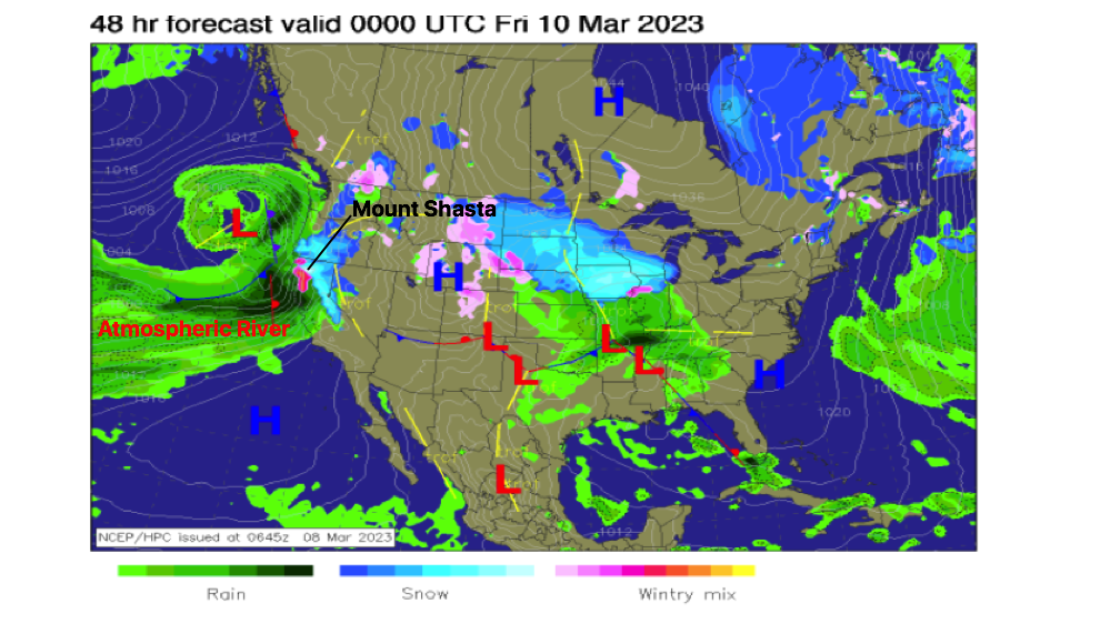
Over the last 24 hours mountain temperatures have sat in the upper teens with light to moderate winds blowing from the west and southwest. Overnight the mountains picked up a healthy seven inches of new snow with Ash Creek Butte reporting 14 inches. This morning will give way to the final flurries of snowfall as the storm departs the region. This departure will cause winds to shift to a northwest direction for a short period before shifting back to a westerly flow. A brief intermission between storms may allow for partial clearing of skies before the next storm wave crashes over the region this afternoon. Temperatures are expected to remain cool enough that snow showers will commence early evening in tow of the preceding storm. An atmospheric river event is stewing as another arctic low takes up position off the coast pulling in moisture originating from the tropics. Our region remains on the northern edge and will receive significant impacts over the next 72 hours.
Today 7-8 Weather :
Snow showers likely, mainly after 10am. Wind chill values as low as -2
Today 7-8 Wind Direction:
SW
Today 8-9 Weather:
Snow showers likely. The snow could be heavy at times. Breezy, with gusts as high as 41 mph. Wind chill values as low as -29
Today 8-9 Wind Direction:
W
Tomorrow 7-8 Weather:
A chance of snow showers before 10am, then snow after 10am. The snow could be heavy at times. Windy, with gusts as high as 60 mph. Wind chill values as low as zero
Tomorrow 7-8 Wind Direction:
Ss
Tomorrow 8-9 Weather:
A chance of snow showers before 10am, then snow after 10am. The snow could be heavy at times. Wind chill values as low as -18. Winds could gust as high as 115 mph
Tomorrow 8-9 Wind Direction:
SW
Tonight 7-8 Weather:
Snow showers likely, mainly before 4am. Breezy, with wind chill values as low as zero. Winds could gust as high as 44 mph
Tonight 7-8 Wind Direction:
S
Tonight 8-9 Weather:
Snow showers likely, mainly before 4am. The snow could be heavy at times. Wind chill values as low as -19
Tonight 8-9 Wind Direction:
SW
19
16
25
20
142
8
0
15
11.5
22
15.5
178.8
6.2
0
Grey Butte Temp Min:
10.5
Grey Butte Temp Max:
20.5
Grey Butte Temp Avg:
14.5
Grey Butte Wind Gust Max:
36.8
Castle Lake Temp Max:
30.5
Mount Eddy Temp Min:
11.5
Mount Eddy Temp Max:
22.5
Mount Eddy Temp Avg:
17.5
Mount Eddy Wind Gust Max:
5.85
Mount Eddy Snow Depth:
151
Ash Creek Bowl Temp Cur:
16.5
Ash Creek Bowl Temp Min:
13
Ash Creek Bowl Temp Max:
18
Ash Creek Bowl Temp Avg:
16
Ash Creek Bowl Snow New:
14.2
Ash Creek Ridge Temp Cur:
13
Ash Creek Ridge Temp Min:
9.5
Ash Creek Ridge Temp Max:
15.5
Ash Creek Ridge Temp Avg:
13
Ash Creek Ridge Wind Cur:
0
Ash Creek Ridge Wind Max:
0
Ash Creek Ridge Wind Gust Max:
0
Mt. Shasta City Temp Cur:
30
Mt. Shasta City Temp Min:
24
Mt. Shasta City Temp Max:
33
Mt. Shasta City Temp Avg:
30
Mt. Shasta City Wind Cur:
3
Mt. Shasta City Wind Min:
0
Mt. Shasta City Wind Max:
6
Mt. Shasta City Wind Avg:
2.5
Mt. Shasta City Wind Avg:
N
Grey Butte Wind Avg:
10.5
Ash Creek Ridge Wind Min:
0
Ash Creek Ridge Wind Avg:
0
Sand Flat Snow Settlement:
0
Ski Bowl Snow Settlement:
0
Mount Eddy Snow Settlement:
0
Ash Creek Bowl Snow Settlement:
0
Measured Precipitation Oct:
30.79
Normal Precipitation Oct:
26.03
Percent Precipitation Oct:
118
Measured Precipitation MTD:
1.08
Normal Precipitation MTD:
1.09
Percent Precipitation MTD:
99
Measured Precipitation YTD:
21.66
Normal Precipitation YTD:
13.79
Percent Precipitation YTD:
157
Tomorrow Wind Max 7-9:
30
Tomorrow Wind Min 7-9:
20
Tonight Wind Max 9-11:
35
Tomorrow Wind Max 9-11:
30
Tonight Wind Min 9-11:
25
Tomorrow Wind Min 9-11:
20
Tonight Snow Max 7-9:
5.00
Tomorrow Snow Max 7-9:
9.00
Tonight Snow Min 7-9:
3.00
Tomorrow Snow Min 7-9:
5.00
Today Snow Max 9-11:
4.00
Tonight Snow Max 9-11:
5.00
Tomorrow Snow Max 9-11:
11.00
Today Snow Min 9-11:
5200.00
Tonight Snow Min 9-11:
3.00
Tomorrow Snow Min 9-11:
7.00
Weather Station Discussion:
The table below summarizes data reported from all of our weather stations over the last 24 hours.
Seasonal Stats Discussion:
The wet season is October 1 through May 1. The table below summarizes recorded vs. normal precipitation amounts for the City of Mount Shasta.
Overall Danger Rating:
Considerable


