Submitted by sclairmont on Sun, 03/12/2023 - 5:36am
Recent Observations:
In the last 24 hours, southwest flow continued to blow across the region, bringing a couple inches of new snow to treeline. Winds remained moderate out of the southwest, with stronger gusts on ridges.
Yesterday's observations came from the Parks Creek area of the Eddy Mountains. Overall, high density new snow from the recent atmospheric river (AR) on March 8/9 blanketed terrain below, near, and above treeline. A punchable surface crust was noted at low elevations up to around 6,500 feet, where the snow begins to soften. The crust is about 1 inch thick, with small surface hoar at the very top. A sun and wind crust was also found with some scabby distribution across north and east aspects below and near treeline. Thick, hard wind slab was present along ridges. Wind transport could be seen with growing cornices on north and west aspects.
A pit was dug at 6,700 feet, on a ENE aspect. The March 8/9 AR snow has consolidated immensely, measuring at 21 inches (54 cm) thick. The AR snow sits on top of older snow from March 4/5 measuring at 15 inches (39 cm) thick. The snowpack is right side up, with dense, well-consolidated snow down to almost a meter deep. Tests resulted in an ECTN down 21 inches just below the AR snow, on a super saturated layer. Shovel shear tests exposed weak interfaces at the super saturated layer (down 21 inches) and at an old melt freeze crust from March 4th (down 36 inches).
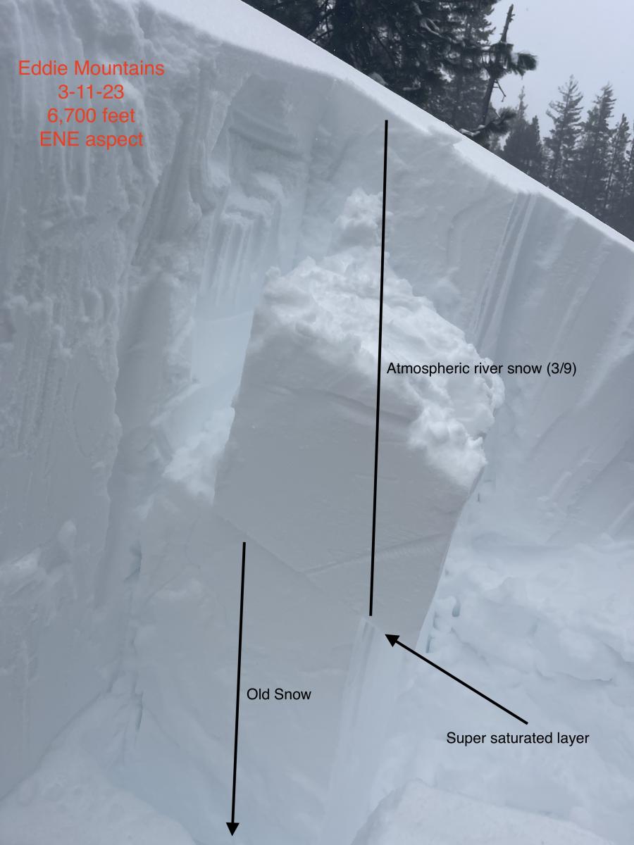
Image: Snowpack stability on a shovel shear test. S. Clairmont
Mountain Weather:
Southwest flow will dominate Siskiyou county today as another atmospheric river event approaches the region. With the atmospheric river having origins in the subtropics, the subsequent warm front will make its way across the Mount Shasta this morning. Precipitation will intensify through the day into the evening, and snow levels will rise to nearly 6,000 feet. Precipitation will come in the form of rain and snow, with 6 to 11 inches of snow possible at higher elevations. Tonight, the offshore upper level trough will swing through the Mount Shasta area, pushing colder temperatures and a surface low into the region early Monday. Precipitation will continue, bringing 8 to 14 inches of new snow overnight. For the next 24 hours, Wind will be moderate to strong, gusting to extreme out of the southwest. Expect gale force winds above treeline. Heavy precipitation and wind is expected through Monday night. High pressure is likely to build over the region on Wednesday and Thursday.
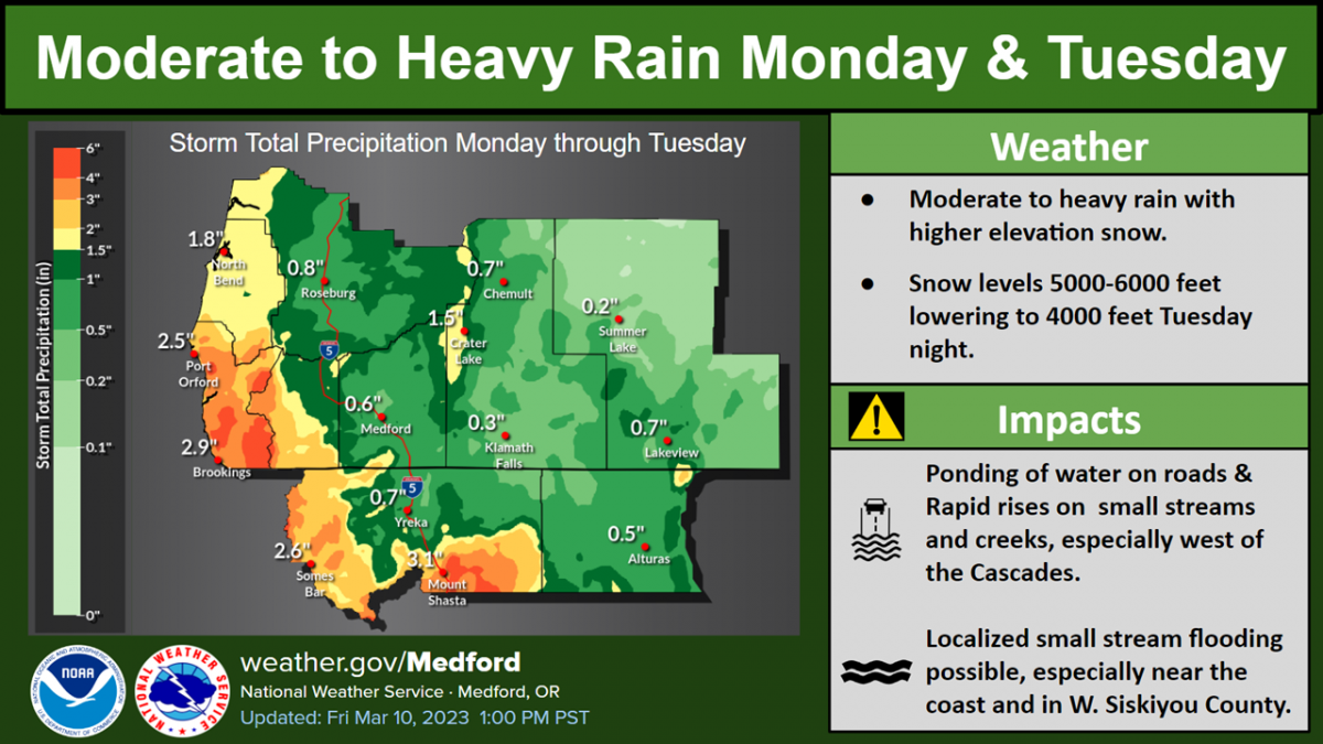
Image: NWS Medford.
Today 7-8 Weather :
Snow. Gusts as high as 28 mph. Snow level around 5,300 feet
Today 7-8 Wind Direction:
SW
Today 8-9 Weather:
Snow. Snow could be heavy at times. Wind chill values as low as -10 F. Windy, with gusts up to 95 mph
Today 8-9 Wind Direction:
SW
Tomorrow 7-8 Weather:
Snow. Snow could be heavy at times. Gusts as high as 43 mph. Snow level around 5,800 feet
Tomorrow 7-8 Wind Direction:
SW
Tomorrow 8-9 Weather:
Snow. Snow could be heavy at times. Wind chill values as low as -7 F. Windy, with gusts up to 105 mph
Tomorrow 8-9 Wind Direction:
SW
Tonight 7-8 Weather:
Snow. Gusts as high as 37 mph. Snow level around 5,900 feet
Tonight 7-8 Wind Direction:
SW
Tonight 8-9 Weather:
Snow. Snow could be heavy at times. Wind chill values as low as -7 F. Windy, with gusts as high as 100 mph
Tonight 8-9 Wind Direction:
SW
28
14
31
26
146
0
0
24.5
10
28
22
186.9
0
0
Grey Butte Temp Max:
26.5
Grey Butte Temp Avg:
21.5
Grey Butte Wind Cur:
13.5
Grey Butte Wind Max:
13.5
Grey Butte Wind Gust Max:
36.8
Castle Lake Temp Cur:
-38
Castle Lake Temp Min:
-39.5
Castle Lake Temp Max:
-37
Castle Lake Temp Avg:
-39
Mount Eddy Temp Min:
14.5
Mount Eddy Temp Avg:
25.5
Mount Eddy Wind Gust Max:
4.74
Mount Eddy Snow Depth:
151
Ash Creek Bowl Temp Cur:
26.5
Ash Creek Bowl Temp Min:
18
Ash Creek Bowl Temp Max:
26.5
Ash Creek Bowl Temp Avg:
23
Ash Creek Bowl Snow New:
0
Ash Creek Ridge Temp Cur:
23.5
Ash Creek Ridge Temp Min:
13
Ash Creek Ridge Temp Max:
24
Ash Creek Ridge Temp Avg:
20
Ash Creek Ridge Wind Cur:
0
Ash Creek Ridge Wind Max:
0
Ash Creek Ridge Wind Gust Max:
0
Mt. Shasta City Temp Cur:
37
Mt. Shasta City Temp Min:
22
Mt. Shasta City Temp Max:
40
Mt. Shasta City Temp Avg:
33.5
Mt. Shasta City Wind Cur:
10
Mt. Shasta City Wind Min:
0
Mt. Shasta City Wind Max:
10
Mt. Shasta City Wind Avg:
2
Mt. Shasta City Wind Avg:
N
Ash Creek Ridge Wind Min:
0
Ash Creek Ridge Wind Avg:
0
Sand Flat Snow Settlement:
2
Ski Bowl Snow Settlement:
1.7
Mount Eddy Snow Settlement:
2.5
Ash Creek Bowl Snow Settlement:
2.3
Measured Precipitation Oct:
33.71
Normal Precipitation Oct:
27.26
Percent Precipitation Oct:
124
Measured Precipitation MTD:
4
Normal Precipitation MTD:
2.32
Percent Precipitation MTD:
172
Measured Precipitation YTD:
24.58
Normal Precipitation YTD:
15.02
Percent Precipitation YTD:
164
Tomorrow Wind Max 7-9:
30
Tomorrow Wind Min 7-9:
20
Tonight Wind Max 9-11:
60
Tomorrow Wind Max 9-11:
60
Tonight Wind Min 9-11:
50
Tomorrow Wind Min 9-11:
50
Today Snow Max 7-9:
11.00
Tonight Snow Max 7-9:
14.00
Tomorrow Snow Max 7-9:
22.00
Tonight Snow Min 7-9:
8.00
Tomorrow Snow Min 7-9:
16.00
Today Snow Max 9-11:
11.00
Tonight Snow Max 9-11:
14.00
Tomorrow Snow Max 9-11:
22.00
Today Snow Min 9-11:
6.00
Tonight Snow Min 9-11:
8.00
Tomorrow Snow Min 9-11:
16.00
Weather Station Discussion:
The table below summarizes data reported from all of our weather stations over the last 24 hours.
Seasonal Stats Discussion:
The wet season is October 1 through May 1. The table below summarizes recorded vs. normal precipitation amounts for the City of Mount Shasta.
Overall Danger Rating:
Moderate


