Submitted by sclairmont on Mon, 03/13/2023 - 4:55am
Recent Observations:
In the last 24 hours, southwest flow continued for the Mount Shasta region. Around 7 inches of high-density new snow has fallen near treeline. Winds remained moderate, with strong to extreme gusts near and above treeline. On Gray Butte, a gust of 49 mph was recorded at 9 pm last night. Mount Shasta City recorded 0.68 inches of water in the last 24 hours. Temperatures remained relatively warm, with a low of 25 degrees F at 7,200 feet.
Yesterday's observations came from the Power Lines route via Old McCloud Road. Heavy rain was encountered until about 5,000 feet, where the rain turned to large moist snowflakes. The top few inches of snow have become very wet and heavy, sitting on top of older, low-density snow. The observed snowpack felt upside down in density. Precipitation intensity increased with higher elevation, exceeding 1 inch/hr accumulation rates. Winds remained calm to light below 6,000 feet.
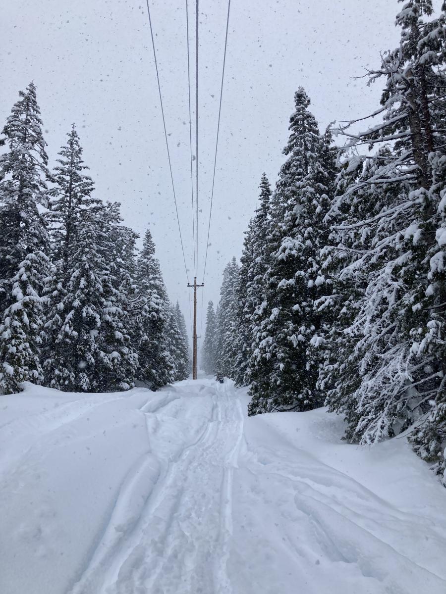
Image: Large wet snowflakes falling around 5,500 feet. S. Clairmont
Mountain Weather:
Siskiyou county remains in the northern periphery of a large atmospheric river. Today, southwest flow will continue for the forecast area. Rain, snow, and wind will continue to be the story today. This afternoon, an upper level trough and its associated cold front will swing inland, bringing enhanced precipitation rates. Significant precipitation rates are expected from this afternoon until Tuesday. Around 11 to 22 inches of new snow is expected by tomorrow morning. Snow levels will be between 5,500 and 6,000 feet over the next two days. Snow levels will lower to nearly 2,000 feet after the front passes on Wednesday. Below treeline, winds will remain moderate, with strong gusts out of the southwest. Near and above treeline, southwest winds will be strong to extreme, with gale force gusts. High pressure is likely to build on Wednesday and Thursday.
On a different note, a flood watch is issued for the Mount Shasta area.
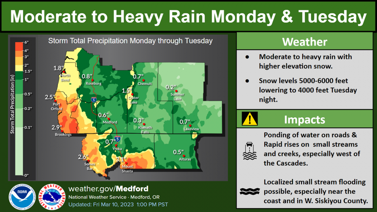
Image: NWS Medford.
Today 7-8 Weather :
Snow. Snow could be heavy at times. Gusts up to 43 mph. Snow level around 5,900 feet
Today 7-8 Wind Direction:
S
Today 8-9 Weather:
Snow. Snow could be heavy at times. Wind chill values as low as -5 F. Windy, with gusts up to 85 mph
Today 8-9 Wind Direction:
SW
Tomorrow 7-8 Weather:
Snow. Snow could be heavy at times. Windy, With gusts up to 55 mph. Snow level around 5,500 feet
Tomorrow 7-8 Wind Direction:
S
Tomorrow 8-9 Weather:
Snow. Snow could be heavy at times. Wind chill values as low as -6 F. Windy, with gusts up to 105 mph
Tomorrow 8-9 Wind Direction:
SW
Tonight 7-8 Weather:
Snow. Snow could be heavy at times. Breezy, with gusts up to 39 mph. Snow level around 5,700 feet
Tonight 7-8 Wind Direction:
S
Tonight 8-9 Weather:
Snow. Snow could be heavy at times. Wind chill values as low as -7 F. Windy, with gusts as high as 95 mph
Tonight 8-9 Wind Direction:
SW
31
28
33
31
151
5
0
28
25.5
30.5
28
193.4
6.5
0
Grey Butte Temp Cur:
27.5
Grey Butte Temp Max:
29.5
Grey Butte Wind Max:
19.5
Grey Butte Wind Gust Max:
49.07
Castle Lake Temp Cur:
-37.5
Castle Lake Temp Min:
-38.5
Castle Lake Temp Max:
-36
Castle Lake Temp Avg:
-37.5
Mount Eddy Temp Avg:
31.5
Mount Eddy Wind Gust Max:
7.03
Mount Eddy Snow Depth:
153.7
Ash Creek Bowl Temp Cur:
29.5
Ash Creek Bowl Temp Min:
27
Ash Creek Bowl Temp Max:
30
Ash Creek Bowl Temp Avg:
28.5
Ash Creek Bowl Snow New:
0
Ash Creek Ridge Temp Cur:
26.5
Ash Creek Ridge Temp Min:
24.5
Ash Creek Ridge Temp Max:
27.5
Ash Creek Ridge Temp Avg:
26
Ash Creek Ridge Wind Cur:
0
Ash Creek Ridge Wind Max:
0
Ash Creek Ridge Wind Gust Max:
0
Mt. Shasta City Temp Cur:
41
Mt. Shasta City Temp Min:
34
Mt. Shasta City Temp Max:
44
Mt. Shasta City Temp Avg:
39.5
Mt. Shasta City Wind Cur:
6
Mt. Shasta City Wind Min:
0
Mt. Shasta City Wind Max:
7
Mt. Shasta City Wind Avg:
4
Grey Butte Wind Min:
10.5
Ash Creek Ridge Wind Min:
0
Ash Creek Ridge Wind Avg:
0
Sand Flat Snow Settlement:
0
Ski Bowl Snow Settlement:
0
Mount Eddy Snow Settlement:
0
Ash Creek Bowl Snow Settlement:
0.1
Measured Precipitation Oct:
34.32
Normal Precipitation Oct:
27.46
Percent Precipitation Oct:
125
Measured Precipitation MTD:
4.61
Normal Precipitation MTD:
2.52
Percent Precipitation MTD:
183
Measured Precipitation YTD:
25.19
Normal Precipitation YTD:
15.22
Percent Precipitation YTD:
166
Tomorrow Wind Max 7-9:
30
Tomorrow Wind Min 7-9:
20
Tonight Wind Max 9-11:
45
Tomorrow Wind Max 9-11:
50
Tonight Wind Min 9-11:
35
Tomorrow Wind Min 9-11:
40
Today Snow Max 7-9:
10.00
Tonight Snow Max 7-9:
12.00
Tomorrow Snow Max 7-9:
19.00
Tonight Snow Min 7-9:
6.00
Tomorrow Snow Min 7-9:
13.00
Today Snow Max 9-11:
10.00
Tonight Snow Max 9-11:
12.00
Tomorrow Snow Max 9-11:
19.00
Today Snow Min 9-11:
5.00
Tonight Snow Min 9-11:
6.00
Tomorrow Snow Min 9-11:
13.00
Weather Station Discussion:
The table below summarizes data reported from all of our weather stations over the last 24 hours.
Seasonal Stats Discussion:
The wet season is October 1 through May 1. The table below summarizes recorded vs. normal precipitation amounts for the City of Mount Shasta.
Overall Danger Rating:
Considerable


