You are here

Forecast Addendum 3/17/2023 - 07:00am

Submitted by nmeyers on Fri, 03/17/2023 - 5:27am
Recent Observations: 

Winter weather, atmospheric rivers and strong wind has all taken a time-out the past couple days. Yesterday hosted clear, blue sky with light wind on Mount Shasta. Temperatures ranged from 18 to 40 deg F. Wind has averaged 10 mi/hr out of the east. A wide-ranging snowmobile tour from town to 10,000 feet was had, continuing to observe the aftermath of the widespread avalanche cycle that occurred earlier in the week. Below treeline is a rain runnel mess, rough, soft to hard runnel features, not pleasurable in any way. Near treeline, above ~6,700 feet, things start to get a little better. Trees are drippin' and bomin' and snow is variable hot powder, heavy and moist. Expect crusts. Above treeline is smooth and completely caked. Mount Shasta is looking fantastic, and a long and glorious spring ski season is guaranteed at this point. Wind effect is minimal due to the heavy, wet nature of the snow. Soft, mostly smooth surfaces dominate. Ridge routes have supportable snow with ~6 inch boot penetration. Gullies and bowls host deeper conditions. Earlier in the week, near treeline snow depth crested 200 inches, topping out at 207 inches on March 13th. Since then, the snowpack has settled 13 inches. We've observed a few small loose wet slides and roller balls on these sunny days, but other than that, it's been quiet on the home front. 


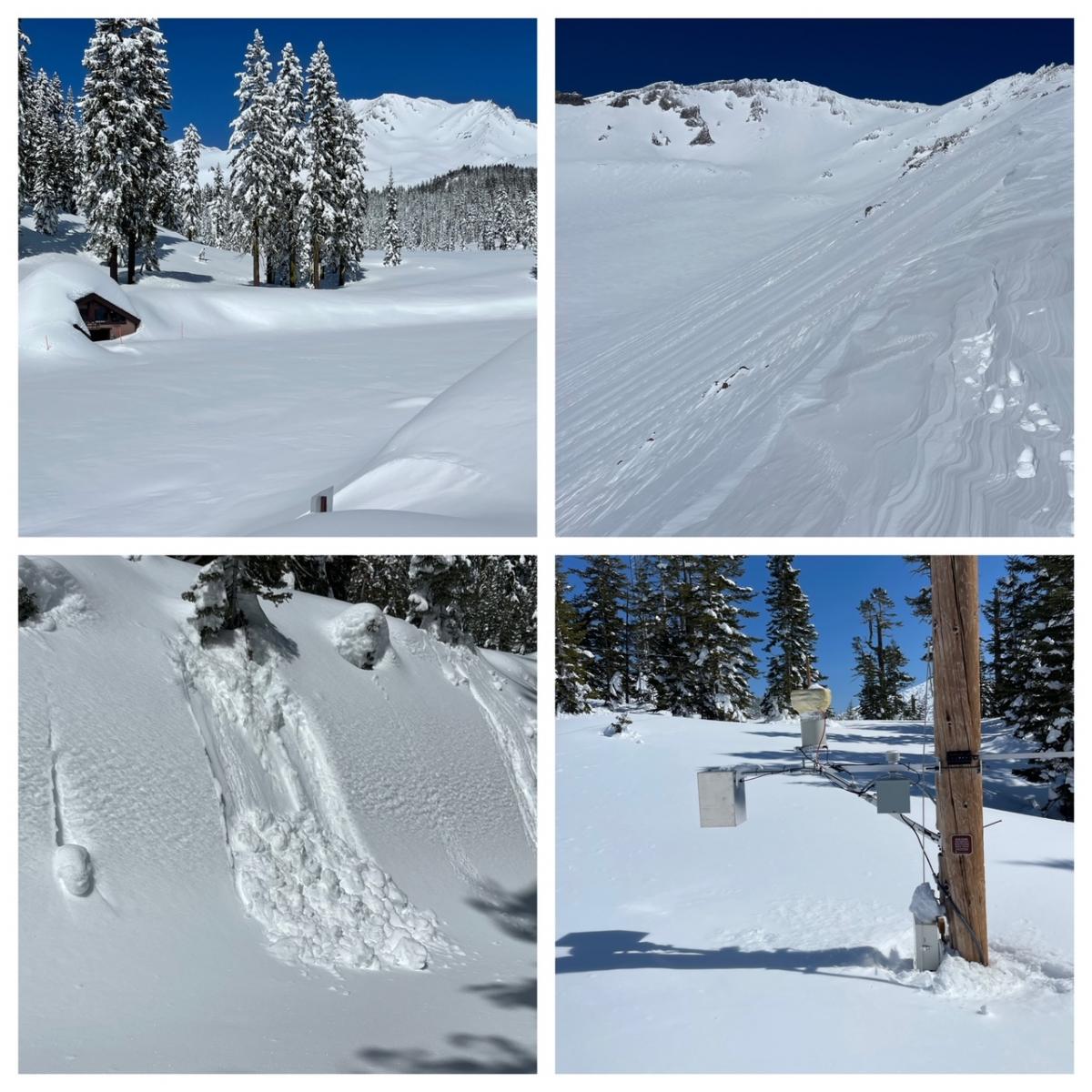
Clockwise from top left: Bunny Flat, unplowed and buried with Mount Shasta in the background / Green Butte Ridge and Avalanche Gulch viewed from 10,000 feet / Old Ski Bowl weather station. Snow depth sensor is 20 feet off the ground! / Small, greasy, loose-wet slides on sunny aspects yesterday, below treeline [Photos: Meyers]

Mountain Weather: 

Drier air and much more tranquil weather is the story across much of the West for the end of the week and into the first part of the weekend. Temperatures will be slightly below normal. A new storm system will be approaching the West Coast by the latter part of the weekend, with the next round of precipitation likely reaching northern and central California by early on Sunday. The area is under the influence of high pressure, which will allow for mild temperatures and sunny skies this afternoon. High pressure will begin to displace tomorrow. A low pressure system drops on Sunday. This will kick off a period of impactful weather.


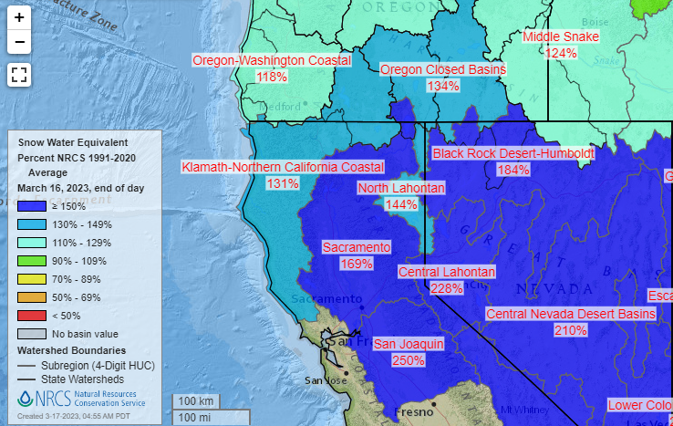
                      NRCS National Water and Climate Center - SWE Percent of Average

Today 7-8 Weather : 
Mostly sunny, increasing clouds
Today 7-8 Wind Direction: 
SE
Today 8-9 Weather: 
Mostly sunny, increasing clouds
Today 8-9 Wind Direction: 
SW
Tomorrow 7-8 Weather: 
Mostly sunny, increasing clouds
Tomorrow 7-8 Wind Direction: 
SE
Tomorrow 8-9 Weather: 
Mostly sunny, increasing clouds
Tomorrow 8-9 Wind Direction: 
S
Tonight 7-8 Weather: 
Partly cloudy
Tonight 7-8 Wind Direction: 
SE
Tonight 8-9 Weather: 
Partly cloudy
Tonight 8-9 Wind Direction: 
S
Today 7-8 Temp: 
36
Today 8-9 Temp: 
21
Tomorrow 7-8 Temp: 
36
Tomorrow 8-9 Temp: 
20
Tonight 7-8 Temp: 
22
Tonight 8-9 Temp: 
7
14
14
47
27
153
0
0
19.5
18
40
27.5
194.9
0
0
Grey Butte Temp Cur: 
25
Grey Butte Temp Min: 
23.5
Grey Butte Temp Max: 
32.5
Grey Butte Temp Avg: 
26.5
Grey Butte Wind Cur: 
3.5
Grey Butte Wind Max: 
25
Grey Butte Wind Gust Max: 
42.93
Grey Butte Wind Avg: 
E
Castle Lake Temp Cur: 
-37.5
Castle Lake Temp Min: 
-38
Castle Lake Temp Max: 
-37
Castle Lake Temp Avg: 
-37.5
Mount Eddy Temp Cur: 
18.5
Mount Eddy Temp Min: 
17.5
Mount Eddy Temp Max: 
37
Mount Eddy Temp Avg: 
26
Mount Eddy Wind Cur: 
3.5
Mount Eddy Wind Max: 
4
Mount Eddy Wind Gust Max: 
5.66
Mount Eddy Wind Avg: 
WSW
Mount Eddy Snow Depth: 
156.2
Mount Eddy Snow New: 
0
Ash Creek Bowl Temp Cur: 
17.5
Ash Creek Bowl Temp Min: 
14
Ash Creek Bowl Temp Max: 
37.5
Ash Creek Bowl Temp Avg: 
23
Ash Creek Bowl Snow New: 
0
Ash Creek Ridge Temp Cur: 
19.5
Ash Creek Ridge Temp Min: 
14
Ash Creek Ridge Temp Max: 
31
Ash Creek Ridge Temp Avg: 
21.5
Ash Creek Ridge Wind Cur: 
3
Ash Creek Ridge Wind Max: 
5
Ash Creek Ridge Wind Gust Max: 
12.8
Mt. Shasta City Temp Cur: 
25
Mt. Shasta City Temp Min: 
20
Mt. Shasta City Temp Max: 
51
Mt. Shasta City Temp Avg: 
35
Mt. Shasta City Wind Cur: 
0
Mt. Shasta City Wind Min: 
0
Mt. Shasta City Wind Max: 
6
Mt. Shasta City Wind Avg: 
1
Mt. Shasta City Wind Avg: 
N
Ski Bowl Comments: 
Water content n/a
Grey Butte Wind Min: 
2
Grey Butte Wind Avg: 
10.5
Caslte Lake Comments: 
Snow depth sensor down
Mount Eddy Wind Min: 
0.5
Mount Eddy Wind Avg: 
2.5
Ash Creek Ridge Wind Min: 
0
Ash Creek Ridge Wind Avg: 
2
Sand Flat Snow Settlement: 
4
Ski Bowl Snow Settlement: 
3.9
Mount Eddy Snow Settlement: 
3.1
Ash Creek Bowl Snow Settlement: 
0
Measured Precipitation Oct: 
36.5
Normal Precipitation Oct: 
28.17
Percent Precipitation Oct: 
130
Measured Precipitation MTD: 
6.79
Normal Precipitation MTD: 
3.23
Percent Precipitation MTD: 
210
Measured Precipitation YTD: 
27.37
Normal Precipitation YTD: 
15.93
Percent Precipitation YTD: 
172
Today SWE: 
0.00
Tonight SWE: 
0.00
Tomorrow SWE: 
0.00
Today Wind Max 7-9: 
10
Tonight Wind Max 7-9: 
10
Tomorrow Wind Max 7-9: 
15
Today Wind Min 7-9: 
0
Tonight Wind Min 7-9: 
0
Tomorrow Wind Min 7-9: 
5
Today Wind Max 9-11: 
10
Tonight Wind Max 9-11: 
15
Tomorrow Wind Max 9-11: 
20
Today Wind Min 9-11: 
0
Tonight Wind Min 9-11: 
5
Tomorrow Wind Min 9-11: 
10
Today Snow Max 7-9: 
0.00
Tonight Snow Max 7-9: 
0.00
Tomorrow Snow Max 7-9: 
0.00
Today Snow Min 7-9: 
0.00
Tonight Snow Min 7-9: 
0.00
Tomorrow Snow Min 7-9: 
0.00
Today Snow Max 9-11: 
0.00
Tonight Snow Max 9-11: 
0.00
Tomorrow Snow Max 9-11: 
0.00
Today Snow Min 9-11: 
0.00
Tonight Snow Min 9-11: 
0.00
Tomorrow Snow Min 9-11: 
0.00
Ash Creek Bowl HS: 
174.7
Weather Station Discussion: 
The table below summarizes data reported from all of our weather stations over the last 24 hours.
Seasonal Stats Discussion: 
The wet season is October 1 through May 1. The table below summarizes recorded vs. normal precipitation amounts for the City of Mount Shasta.
Overall Danger Rating: 
Low
Current Time: 
3:00 AM