Submitted by sclairmont on Mon, 03/20/2023 - 5:04am
Recent Observations:
In the last 24 hours, southwest flow carried a system through the forecast area with a fresh coat of snow above 5,000 feet. With no new snow overnight, total storm accumulation from this system is about five inches. This is the low end of what was forecasted. That being said, southerly wind and favorable storm direction gave some areas six or seven inches of new snow. Wind remained lighter than expected, mostly in the light to moderate range. Periods of strong wind were observed over ridges.
Yesterday's observations came from the Gray Butte area. As of 12pm, the average new snow accumulation was about five to six inches. The new snow was found laying on top of an old solar crust on all observed terrain. The thickness and supportability of the crust varied depending on aspect. Solar aspects held a thicker punchable crust, while northerly terrain had a very thin and sometimes unnoticeable crust. There were a few signs of instability on northerly terrain. The most obvious were the easily triggered dry-loose avalanches due to ski cuts. These dry-loose avalanches could entrain moderate amounts of snow and run up to 100 feet. Some cracking and slab characteristics were also observed on steeper convexities under skis.
Two pits were dug yesterday. Both were at 7,900 feet at opposite sides of a ridgeline. The first pit was on a northwest aspect. As mentioned, five inches of new snow was found sitting on top of the old surface crust. On compression tests, failure occurred on tap 12 with a sudden collapse at the new snow - old crust interface (down 14 cm). The second pit was on a southeast aspect. This held a far thicker crust (6 cm) and more new snow (17 cm) compared to pit #1. Upon compression test, failure occurred on isolation just below the old crust. On ECT, failure also occurred on isolation.
Another party from the Eddy Mountains reported three to six inches of new snow, strong wind over ridges, sensitive wind slabs up to 1 foot deep, and some wet loose activity.
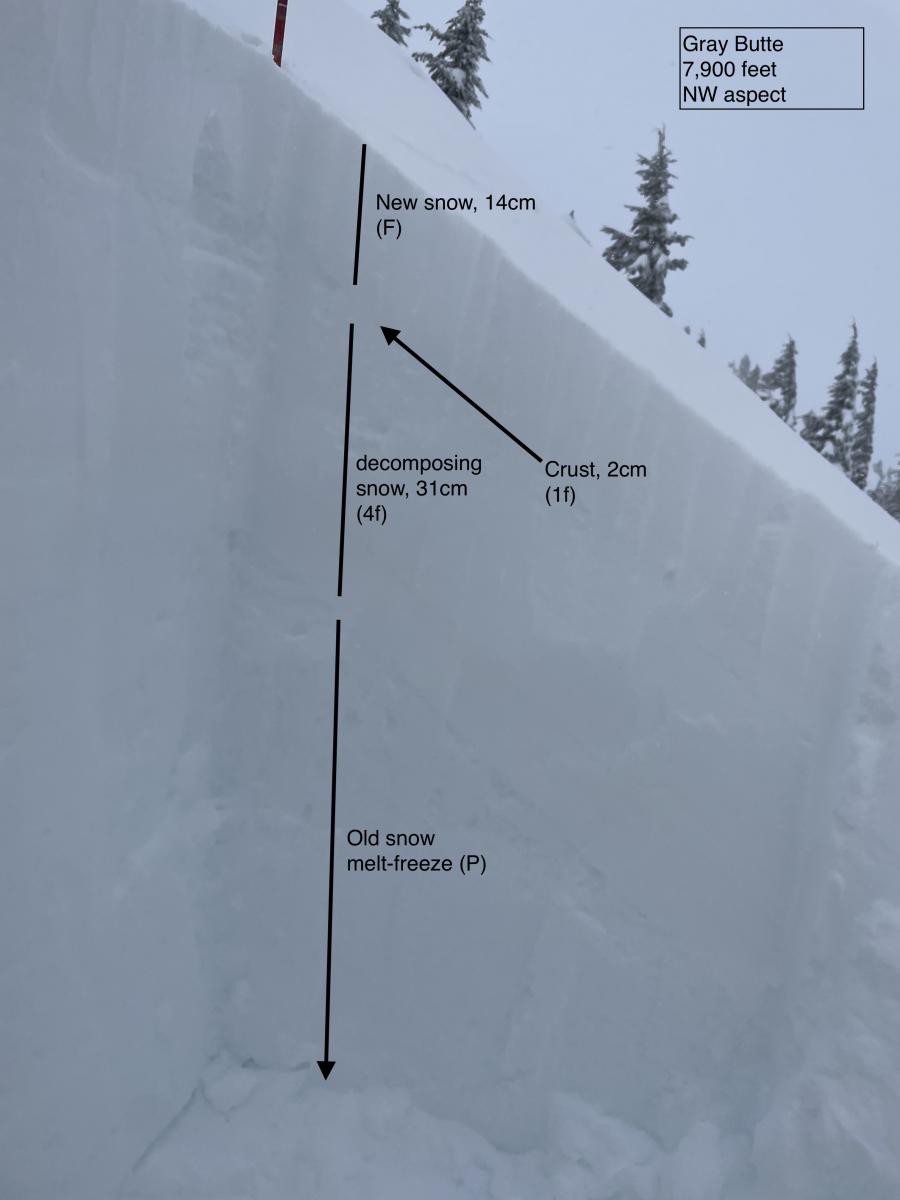
Image: Pit #1 from 03.19.2023. S. Clairmont
Mountain Weather:
The next few days are defined by multiple weak systems providing cooler temperatures and minimal amounts of precipitation. All things considered, no significant storms appear to be heading our way. For today, a weak upper trough approaching the coast is bringing isolated to scattered showers over Siskiyou county this morning. Ridging will build in the afternoon, resulting in mostly dry weather into the evening. The next system to arrive will be late tonight. This system is more centered to hit central California, giving an easterly flow to Mount Shasta on Tuesday. Light precipitation is expected. We will shift to a northwest flow starting Thursday, bringing cooler air down to the forecast area. Snow levels will be at the base through tonight and Tuesday. Winds remain light out of the southwest, shifting easterly on Tuesday.
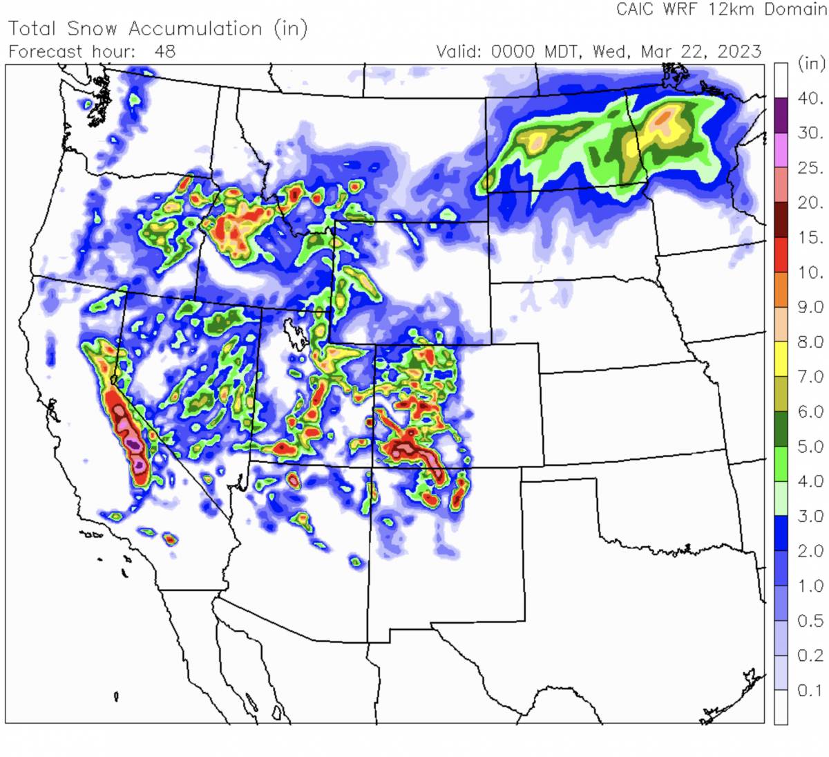
Image: CAIC's WRF 48-hour total snow accumulation forecast. As you can see, the Sierras will see most of the snow from the next couple systems.
Today 7-8 Weather :
Partly sunny. Gusts up to 21 mph. Snow level will be at the base
Today 7-8 Wind Direction:
SW
Today 8-9 Weather:
Mostly cloudy, then gradually becoming sunny. Windy, with gusts up to 50 mph. Wind chill values as low as -22 F
Today 8-9 Wind Direction:
W
Tomorrow 7-8 Weather:
Chance of snow showers, mainly after 11am. Mostly sunny. Breezy, with gusts up to 34 mph. Snow level will be at the base
Tomorrow 7-8 Wind Direction:
NE
Tomorrow 8-9 Weather:
Chance of snow showers, mainly after 11am. Mostly sunny. Windy, with gusts up to 50 mph. Wind chill values as low as -14 F
Tomorrow 8-9 Wind Direction:
E
Tonight 7-8 Weather:
Partly cloudy. Gusts up to 20 mph. Snow level at the base
Tonight 7-8 Wind Direction:
SE
Tonight 8-9 Weather:
Partly cloudy. Windy, with gusts up to 50 mph. Wind chill values as low as -15 F
Tonight 8-9 Wind Direction:
SW
27
25
33
30
150
2
0
22
21.5
28
25.5
193.1
3.1
0
Grey Butte Temp Cur:
21.5
Grey Butte Temp Min:
21.5
Grey Butte Temp Max:
26.5
Grey Butte Temp Avg:
24.5
Grey Butte Wind Cur:
20.5
Grey Butte Wind Max:
23.5
Grey Butte Wind Gust Max:
49.07
Castle Lake Temp Avg:
71.5
Castle Lake Snow Depth:
171
Castle Lake Snow New:
1.8
Mount Eddy Temp Max:
34.5
Mount Eddy Wind Gust Max:
6.39
Mount Eddy Snow Depth:
154.8
Ash Creek Bowl Temp Cur:
23
Ash Creek Bowl Temp Min:
21.5
Ash Creek Bowl Temp Max:
29
Ash Creek Bowl Temp Avg:
26.5
Ash Creek Bowl Snow New:
0
Ash Creek Ridge Temp Cur:
19.5
Ash Creek Ridge Temp Min:
19.5
Ash Creek Ridge Temp Max:
25.5
Ash Creek Ridge Temp Avg:
23
Ash Creek Ridge Wind Cur:
0
Ash Creek Ridge Wind Max:
13
Ash Creek Ridge Wind Gust Max:
38.8
Mt. Shasta City Temp Cur:
32
Mt. Shasta City Temp Min:
32
Mt. Shasta City Temp Max:
43
Mt. Shasta City Temp Avg:
37.5
Mt. Shasta City Wind Cur:
0
Mt. Shasta City Wind Min:
0
Mt. Shasta City Wind Max:
4
Mt. Shasta City Wind Avg:
0.5
Mt. Shasta City Wind Avg:
N
Ash Creek Ridge Wind Min:
0
Ash Creek Ridge Wind Avg:
0.5
Sand Flat Snow Settlement:
0
Ski Bowl Snow Settlement:
0
Castle Lake Snow Settlement:
0
Mount Eddy Snow Settlement:
0
Ash Creek Bowl Snow Settlement:
0
Measured Precipitation Oct:
36.5
Normal Precipitation Oct:
28.5
Percent Precipitation Oct:
128
Measured Precipitation MTD:
6.79
Normal Precipitation MTD:
3.56
Percent Precipitation MTD:
191
Measured Precipitation YTD:
27.37
Normal Precipitation YTD:
16.26
Percent Precipitation YTD:
168
Tomorrow Wind Max 7-9:
20
Tomorrow Wind Min 7-9:
10
Tonight Wind Max 9-11:
20
Tomorrow Wind Max 9-11:
30
Tonight Wind Min 9-11:
10
Tomorrow Wind Min 9-11:
20
Tonight Snow Max 7-9:
1.00
Tomorrow Snow Max 7-9:
2.00
Tonight Snow Min 7-9:
0.00
Tomorrow Snow Min 7-9:
0.00
Today Snow Max 9-11:
1.00
Tonight Snow Max 9-11:
1.00
Tomorrow Snow Max 9-11:
2.00
Today Snow Min 9-11:
0.00
Tonight Snow Min 9-11:
0.00
Tomorrow Snow Min 9-11:
0.00
Weather Station Discussion:
The table below summarizes data reported from all of our weather stations over the last 24 hours.
Seasonal Stats Discussion:
The wet season is October 1 through May 1. The table below summarizes recorded vs. normal precipitation amounts for the City of Mount Shasta.
Overall Danger Rating:
Moderate


