Submitted by efalconer on Tue, 03/21/2023 - 5:25am
Recent Observations:
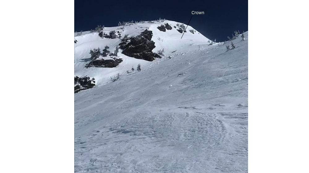
Yesterday in the Old Ski Bowl basin I spotted two small recent wind slab avalanches. The first one observed off the Saint Germaine ridgeline on an east aspect. The second occurred off the south face of Green Butte. Both involved the recent snow. West and northwesterly winds were observed drifting the recent snowfall. Widespread wind effect was evident on all aspects near and above treeline. Large wind ripples lay across slope faces and textured surfaces existed on roll-overs and ridgelines. The effected snow had some extra girth to it but was not dense enough that skis or a snowmobile struggled to move through it. A stout crust beneath the snow can be found on all aspects at the lower and mid-elevations, with less of a presence on northerly shady slopes. This crust has proven to be both punchy and supportable dependent on aspect and elevation. Cold and brisk upper elevation temperatures kept the snow cold and in place. A melt freeze cycle was experienced in the snowpack at the lower elevations over the duration of the outing.
Mountain Weather:
Over the past 24 hrs mountain temperatures have remained below freezing with an average west and northwest wind direction blowing at moderate speeds with strong gusts. Today a strong low-pressure system will arrive at the central California coast. Our region remains on the north edge of the storm flow and will only receive peripheral weather impacts. As the low moves inland winds will shift counterclockwise with a predominantly east and northeast direction blowing at moderate to strong speeds. Partly clear skies will become mostly cloudy, with mountain temperatures reaching above freezing levels. Light precipitation may occur at upper elevations this evening. Cloudy and cool weather with a chance for snow showers looks to be on the menu for tomorrow.
Today 7-8 Weather :
Partly sunny. A 50 percent chance of snow showers after 11am. Wind gusts as high as 26 mph
Today 7-8 Wind Direction:
E
Today 8-9 Weather:
A 50 percent chance of snow showers after 11am. Partly sunny, with wind chill values as low as -13. Winds could gusts as high as 37 mph
Today 8-9 Wind Direction:
E
Tomorrow 7-8 Weather:
Snow showers likely, mainly after 11am. Mostly cloudy
Tomorrow 7-8 Wind Direction:
SW
Tomorrow 8-9 Weather:
Snow showers, mainly after 11am. Wind chill values as low as -4. Winds could gust as high as 21 mph. Chance of precipitation is 80%
Tomorrow 8-9 Wind Direction:
W
Tonight 7-8 Weather:
Mostly cloudy. Snow showers likely, mainly before 11pm. Wind gusts as high as 21 mph
Tonight 7-8 Wind Direction:
E
Tonight 8-9 Weather:
Snow showers likely, mainly before 11pm. Mostly cloudy, with wind chill values as low as -6. Winds could gust as high as 30 mph
Tonight 8-9 Wind Direction:
E
20
13
40
25
147
0
0
13.5
10.5
31.5
21
190.4
0
0.44
Grey Butte Temp Min:
12.5
Grey Butte Wind Max:
23.5
Grey Butte Wind Gust Max:
36.8
Castle Lake Temp Cur:
83.5
Castle Lake Temp Min:
17.5
Castle Lake Temp Max:
127
Castle Lake Snow Depth:
170.3
Mount Eddy Temp Cur:
21.5
Mount Eddy Wind Gust Max:
5.7
Mount Eddy Snow Depth:
152.6
Ash Creek Bowl Temp Cur:
21.5
Ash Creek Bowl Temp Min:
14
Ash Creek Bowl Temp Max:
29.5
Ash Creek Bowl Temp Avg:
21.5
Ash Creek Bowl Snow New:
0
Ash Creek Ridge Temp Cur:
16
Ash Creek Ridge Temp Min:
12.5
Ash Creek Ridge Temp Max:
23
Ash Creek Ridge Temp Avg:
18
Ash Creek Ridge Wind Cur:
6
Ash Creek Ridge Wind Max:
13
Ash Creek Ridge Wind Gust Max:
23.89
Mt. Shasta City Temp Cur:
28
Mt. Shasta City Temp Min:
28
Mt. Shasta City Temp Max:
45
Mt. Shasta City Temp Avg:
35.5
Mt. Shasta City Wind Cur:
0
Mt. Shasta City Wind Min:
0
Mt. Shasta City Wind Max:
3
Mt. Shasta City Wind Avg:
1
Mt. Shasta City Wind Avg:
N
Ash Creek Ridge Wind Min:
0
Ash Creek Ridge Wind Avg:
3.5
Sand Flat Snow Settlement:
3
Ski Bowl Snow Settlement:
2.6
Castle Lake Snow Settlement:
0.5
Mount Eddy Snow Settlement:
1.9
Ash Creek Bowl Snow Settlement:
0
Measured Precipitation Oct:
36.5
Normal Precipitation Oct:
28.5
Percent Precipitation Oct:
128
Measured Precipitation MTD:
6.79
Normal Precipitation MTD:
3.56
Percent Precipitation MTD:
191
Measured Precipitation YTD:
27.37
Normal Precipitation YTD:
16.26
Percent Precipitation YTD:
168
Tomorrow Wind Max 7-9:
15
Tonight Wind Max 9-11:
20
Tomorrow Wind Max 9-11:
20
Tonight Wind Min 9-11:
10
Tomorrow Wind Min 9-11:
10
Tonight Snow Max 7-9:
2.00
Tomorrow Snow Max 7-9:
3.00
Tonight Snow Min 7-9:
0.00
Tomorrow Snow Min 7-9:
1.00
Today Snow Max 9-11:
1.00
Tonight Snow Max 9-11:
3.00
Tomorrow Snow Max 9-11:
0.00
Today Snow Min 9-11:
0.00
Tonight Snow Min 9-11:
1.00
Tomorrow Snow Min 9-11:
0.00
Weather Station Discussion:
The table below summarizes data reported from all of our weather stations over the last 24 hours.
Seasonal Stats Discussion:
The wet season is October 1 through May 1. The table below summarizes recorded vs. normal precipitation amounts for the City of Mount Shasta.
Overall Danger Rating:
Moderate


