Submitted by sclairmont on Mon, 03/27/2023 - 5:08am
Recent Observations:
Yesterday provided clear and calm conditions across the region. The cold temperatures and scattered showers gave way to sunny skies and a warming trend by mid-afternoon. Wind remained light out of the north. Around one to two inches of low-density snow fell across the Mount Shasta area.
Yesterday's observations came from the Gray Rocks area. The road to Castle Lake is still closed, with one very narrow lane plowed to the Methodist camp. North, east, south aspects held one to inches of new snow on top of a firm surface crust. North facing terrain remained slightly softer, with a less obvious crust underneath the new snow. East facing terrain still held some variable surfaces due to wind effect. Slight cracking was observed between ski tracks. Some old avalanche debris was still visible on north and east facing aspects. Beside the cracking, no significant signs of instability or recent avalanche activity was observed. Snow depth in this area was over 150 inches.
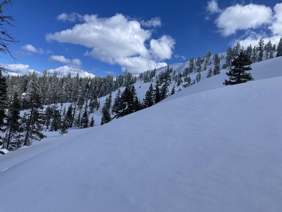
Image: North facing terrain around 5,800 feet. Gray Rocks area.
Mountain Weather:
A brief period of calm weather will continue through this morning. Cold temperatures and light winds are expected through midday. This afternoon, a large storm system off the coast of the Oregon-California border will hit land. This storm will begin to impact the Mount Shasta area by late afternoon. Moderate to heavy snowfall is expected for much of Siskiyou county from Monday evening through Tuesday afternoon. The previous winter storm watch has been upgraded to a winter storm warning, and extended through Wednesday morning. This storm is expected to bring one to three feet of snow as low as the I-5, impacting travel in the area. Around two to four feet of snow is expected at treeline on Mount Shasta. Upper level winds will also elevate with this storm. Southerly winds will be moderate to strong below treeline, and extreme above treeline.
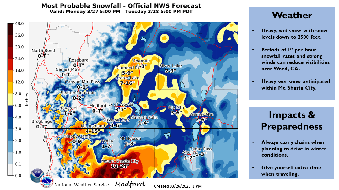
Image: NWS Medford.
Today 7-8 Weather :
A chance of snow after 11am. Cloudy. Windy, with gusts as high as 50 mph. Snow level will be at the base
Today 7-8 Wind Direction:
S
Today 8-9 Weather:
Chance of snow after 11am. Cloudy. Windy, with gusts up to 85 mph. Wind chill values as low as -21 F
Today 8-9 Wind Direction:
NWS
Tomorrow 7-8 Weather:
Snow. Snow could be heavy at times. Windy, with gusts up to 80 mph. Snow level will be at the base
Tomorrow 7-8 Wind Direction:
S
Tomorrow 8-9 Weather:
Snow. Snow could be heavy at times. Windy, with gusts up to 115 mph. Wind chill values as low as -35 F
Tomorrow 8-9 Wind Direction:
S
Tonight 7-8 Weather:
Snow. Snow could be heavy at times. Windy, with gusts up to 80 mph. Snow level will be at the base
Tonight 7-8 Wind Direction:
S
Tonight 8-9 Weather:
Snow. Snow could be heavy at times. Windy, with gusts up to 115 mph. Wind chill values as low as -30 F
Tonight 8-9 Wind Direction:
SW
26
2
29
16
146
0
0
15.5
4
28
15.5
188.6
0
0.01
Grey Butte Temp Cur:
14.5
Grey Butte Temp Avg:
15.5
Grey Butte Wind Max:
10.5
Grey Butte Wind Gust Max:
24.54
Castle Lake Snow Depth:
161.3
Mount Eddy Wind Gust Max:
4.86
Mount Eddy Snow Depth:
150.1
Ash Creek Bowl Temp Cur:
17
Ash Creek Bowl Temp Min:
6.5
Ash Creek Bowl Temp Max:
28.5
Ash Creek Bowl Temp Avg:
15
Ash Creek Bowl Snow New:
0
Ash Creek Ridge Temp Cur:
11
Ash Creek Ridge Temp Min:
4.5
Ash Creek Ridge Temp Max:
31.5
Ash Creek Ridge Temp Avg:
16.5
Ash Creek Ridge Wind Cur:
16
Ash Creek Ridge Wind Max:
16
Ash Creek Ridge Wind Gust Max:
23.7
Mt. Shasta City Temp Cur:
24
Mt. Shasta City Temp Min:
24
Mt. Shasta City Temp Max:
43
Mt. Shasta City Temp Avg:
31.5
Mt. Shasta City Wind Cur:
0
Mt. Shasta City Wind Min:
0
Mt. Shasta City Wind Max:
7
Mt. Shasta City Wind Avg:
2
Mt. Shasta City Wind Avg:
N
Ash Creek Ridge Wind Min:
0
Ash Creek Ridge Wind Avg:
3.5
Sand Flat Snow Settlement:
1
Ski Bowl Snow Settlement:
2
Castle Lake Snow Settlement:
1.7
Mount Eddy Snow Settlement:
1.7
Ash Creek Bowl Snow Settlement:
0
Measured Precipitation Oct:
37.3
Normal Precipitation Oct:
29.74
Percent Precipitation Oct:
125
Measured Precipitation MTD:
7.59
Normal Precipitation MTD:
4.8
Percent Precipitation MTD:
158
Measured Precipitation YTD:
28.17
Normal Precipitation YTD:
17.5
Percent Precipitation YTD:
161
Tomorrow Wind Max 7-9:
35
Tomorrow Wind Min 7-9:
25
Tonight Wind Max 9-11:
75
Tomorrow Wind Max 9-11:
70
Tonight Wind Min 9-11:
65
Tomorrow Wind Min 9-11:
60
Tonight Snow Max 7-9:
18.00
Tomorrow Snow Max 7-9:
19.00
Tonight Snow Min 7-9:
12.00
Tomorrow Snow Min 7-9:
13.00
Today Snow Max 9-11:
0.50
Tonight Snow Max 9-11:
18.00
Tomorrow Snow Max 9-11:
19.00
Today Snow Min 9-11:
0.00
Tonight Snow Min 9-11:
12.00
Tomorrow Snow Min 9-11:
13.00
Weather Station Discussion:
The table below summarizes data reported from all of our weather stations over the last 24 hours.
Seasonal Stats Discussion:
The wet season is October 1 through May 1. The table below summarizes recorded vs. normal precipitation amounts for the City of Mount Shasta.
Overall Danger Rating:
Moderate


