Submitted by sclairmont on Sun, 04/02/2023 - 5:18am
Recent Observations:
The last 24 hours brought westerly flow, moderate to strong westerly winds above treeline, and light precipitation. Gray Butte weather station has recorded moderate westerly with strong gusts since 10am yesterday morning. Snow levels were around 4,800 feet during the day.
Yesterday's observations came from the Parks Creek summit area in the Eddy Mountains. Snow began to accumulate around 6,000 feet, with moderate snowfall continuing through the day. A widespread breakable crust was found on all but the most shaded northerly aspects. At 7,300 feet, winds remained light out of the west, with no wind transport observed.
A pit was dug at 7,200 feet on a northwest aspect in search of the recently active weak layer. The weak layer was found below 71 cm of new snow, albeit thinner and less prominent than other observed areas. Tests resulted in no propagation (ECTX) and no failure (CTN). On a shovel shear test, the weak layer did fail with moderate pressure (Q2/Q3). In addition to test results, no new signs of recent avalanche activity were found. Overall, this weak layer appeared less reactive yesterday in that area, compared to observations earlier this week.
A skier triggered wind slab avalanche occurred on the east bowl of Gray Butte yesterday by stomping on some cornices. It was estimated six to ten inches deep, 150 feet wide, and traveled the full length of the slope (~600 feet). This is a good reminder of the instability that moderate winds can bring. The continued westerly winds surely loaded leeward aspects yesterday.
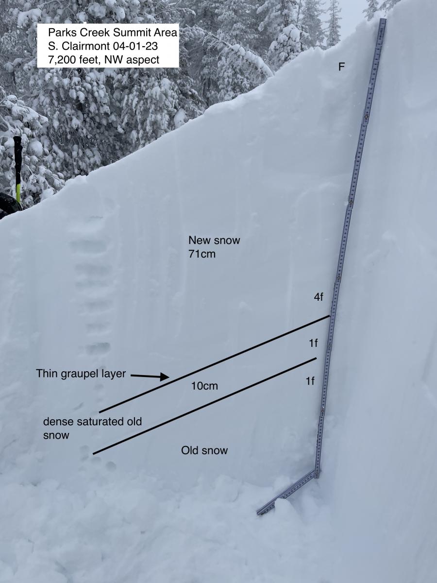
Image: Pit on Parks Creek summit area.
Mountain Weather:
Strong westerly flow aloft continues to bring colder temperatures and light precipitation to Siskiyou county. Scattered showers will continue in the forecast area, a couple inches of snow is possible today and tonight. With the westerly flow, this bulk of the snow will likely fall west of the I-5 with less on Mount Shasta. Current snow levels are around 2,500 feet. Isolated thunderstorms remain possible through today. Strong westerly winds will blow above treeline today, lightening up a bit tonight. Temperatures will continue to be cold, becoming unseasonably cold through tonight. Northwest flow will continue to bring light snow showers over the next few days.
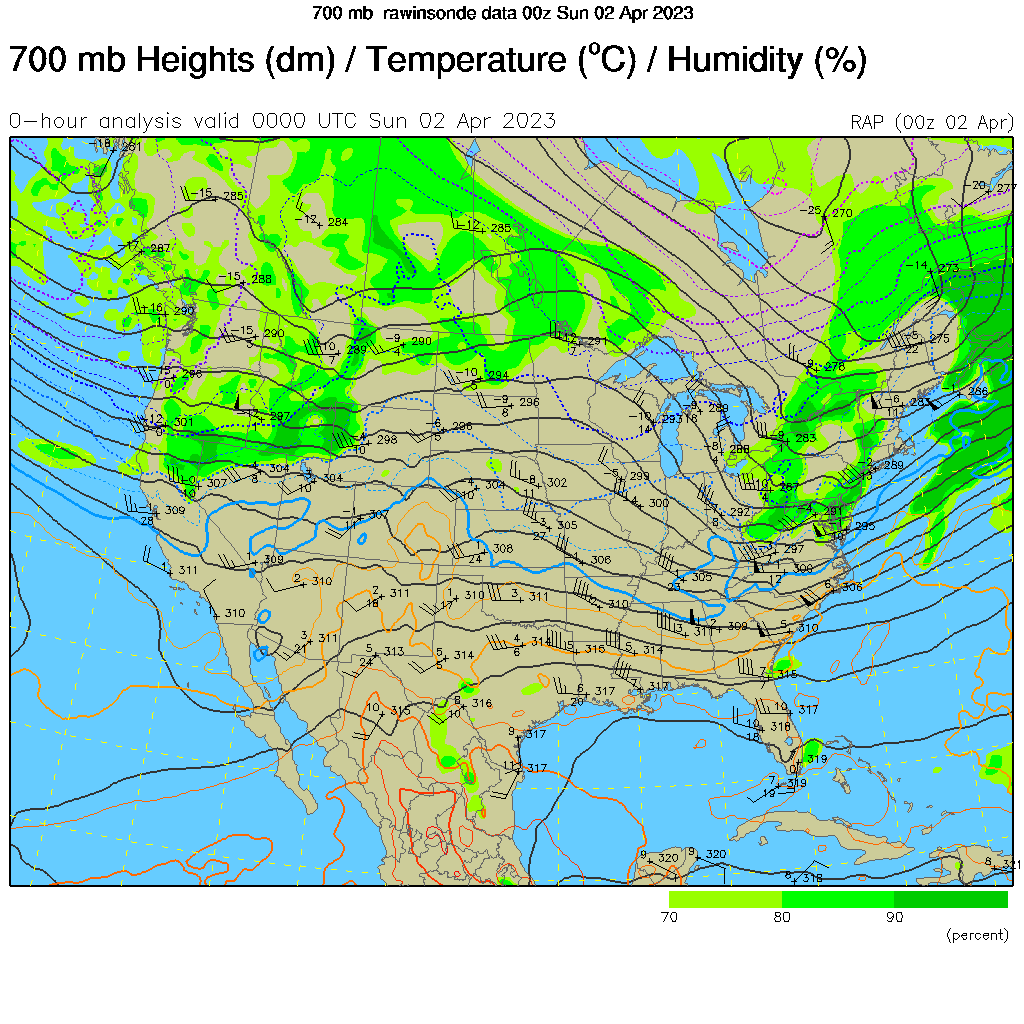
Image: Upper air mass showing westerly flow, and 80-90% RH over Mount Shasta.
Today 7-8 Weather :
Snow showers. Some thunder is possible. Patchy blowing snow. Mostly cloudy. Gusts up to 29 mph. Snow level will be at the base
Today 7-8 Wind Direction:
SW
Today 8-9 Weather:
Snow showers. Widespread blowing snow. Thunder is possible. Windy, with gusts up to 115 mph. Wind chill values as low as -28 F
Today 8-9 Wind Direction:
W
Tomorrow 7-8 Weather:
Partly sunny. Chance of snow. Gusts up to 29 mph. Snow level will be at the base
Tomorrow 7-8 Wind Direction:
NW
Tomorrow 8-9 Weather:
Chance of snow. Partly sunny and cold. Windy, with gusts up to 65 mph. Wind chill values as low as -32 F
Tomorrow 8-9 Wind Direction:
NW
Tonight 7-8 Weather:
Chance of snow. Mostly cloudy. Thunder is possible. Gusts up to 28 mph. Snow level will be at the base
Tonight 7-8 Wind Direction:
NW
Tonight 8-9 Weather:
Snow showers. Mostly cloudy. Windy, with gusts up to 90 mph. Thunder is possible. Wind chill values as low as -31 F
Tonight 8-9 Wind Direction:
NW
26
2
29
16
146
0
0
14
14
28
22
204
0
0
Grey Butte Temp Avg:
22.5
Grey Butte Wind Gust Max:
36.8
Castle Lake Temp Cur:
118
Castle Lake Temp Min:
107.5
Castle Lake Temp Max:
118
Castle Lake Temp Avg:
110
Castle Lake Snow Depth:
180.6
Castle Lake Snow New:
0.4
Mount Eddy Temp Min:
18.5
Mount Eddy Wind Gust Max:
5.95
Mount Eddy Snow Depth:
165.6
Ash Creek Bowl Temp Cur:
17.5
Ash Creek Bowl Temp Min:
17.5
Ash Creek Bowl Temp Max:
32.5
Ash Creek Bowl Temp Avg:
25.5
Ash Creek Bowl Snow New:
0
Ash Creek Ridge Temp Cur:
15.5
Ash Creek Ridge Temp Min:
15.5
Ash Creek Ridge Temp Max:
26.5
Ash Creek Ridge Temp Avg:
22
Ash Creek Ridge Wind Cur:
0
Ash Creek Ridge Wind Max:
0
Ash Creek Ridge Wind Gust Max:
0
Mt. Shasta City Temp Cur:
29
Mt. Shasta City Temp Min:
29
Mt. Shasta City Temp Max:
39
Mt. Shasta City Temp Avg:
35.5
Mt. Shasta City Wind Cur:
0
Mt. Shasta City Wind Min:
0
Mt. Shasta City Wind Max:
5
Mt. Shasta City Wind Avg:
2.5
Mt. Shasta City Wind Avg:
N
Ash Creek Ridge Wind Min:
0
Ash Creek Ridge Wind Avg:
0
Sand Flat Snow Settlement:
1
Ski Bowl Snow Settlement:
0.7
Castle Lake Snow Settlement:
0
Mount Eddy Snow Settlement:
1.7
Ash Creek Bowl Snow Settlement:
16.3
Measured Precipitation Oct:
39.76
Normal Precipitation Oct:
30.68
Percent Precipitation Oct:
130
Measured Precipitation MTD:
0.04
Normal Precipitation MTD:
0.14
Percent Precipitation MTD:
29
Measured Precipitation YTD:
30.63
Normal Precipitation YTD:
18.44
Percent Precipitation YTD:
166
Tomorrow Wind Max 7-9:
20
Tomorrow Wind Min 7-9:
10
Tonight Wind Max 9-11:
35
Tomorrow Wind Max 9-11:
40
Tonight Wind Min 9-11:
25
Tomorrow Wind Min 9-11:
30
Tonight Snow Max 7-9:
2.00
Tomorrow Snow Max 7-9:
2.00
Tonight Snow Min 7-9:
1.00
Tomorrow Snow Min 7-9:
1.00
Today Snow Max 9-11:
3.00
Tonight Snow Max 9-11:
2.00
Tomorrow Snow Max 9-11:
2.00
Today Snow Min 9-11:
2.00
Tonight Snow Min 9-11:
1.00
Tomorrow Snow Min 9-11:
1.00
Weather Station Discussion:
The table below summarizes data reported from all of our weather stations over the last 24 hours.
Seasonal Stats Discussion:
The wet season is October 1 through May 1. The table below summarizes recorded vs. normal precipitation amounts for the City of Mount Shasta.
Overall Danger Rating:
Moderate


