Submitted by efalconer on Tue, 04/04/2023 - 5:29am
Recent Observations:
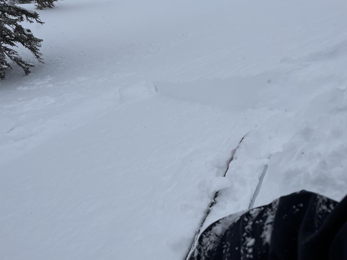
The last 24 hrs have brought strong to extreme northwest winds to the region with an average speed of 18 mph and a max gust of 71 mph. Scattered rates of precipitation have occurred with no real accumulation. Observations from the Old Ski Bowl yesterday found 4 inches of fresh snow near treeline. Snow was observed blowing over ridge tops and across open slopes onto south and east aspects. Wind textured and scoured surfaces were seen on exposed terrain features. Near treeline on a southeast aspect drifts five to eight inch deep sat on top of a uniform crust. Around specific terrain features, like beneath cliffs bands and protected rollovers, larger amounts of drifted snow existed. These were the most sensitive locations we observed for this problem. A party on the east side of the mountain encountered strong northwest winds blowing tons of snow off ridge tops onto east and south aspects. Temperatures remained in the mid-teens with a brisk wind chill. Below treeline no signs of wind effect were observed. Less fresh snow with firmer surfaces beneath exists.
Mountain Weather:
Northwest flow will persist today on the backside of an upper trough. Light and scattered showers may occur along the Cascades this morning, tapering off by mid-day. Low clouds will burn off presenting mostly clear skies. Mountain temperatures will remain below freezing with a high in the mid-twenties. Valleys temperatures could reach as high as 40°F. A warm front will inch closer towards the area Wednesday with possible precipitation beginning Wednesday evening into Thursday. Snow levels look to remain fairly high.
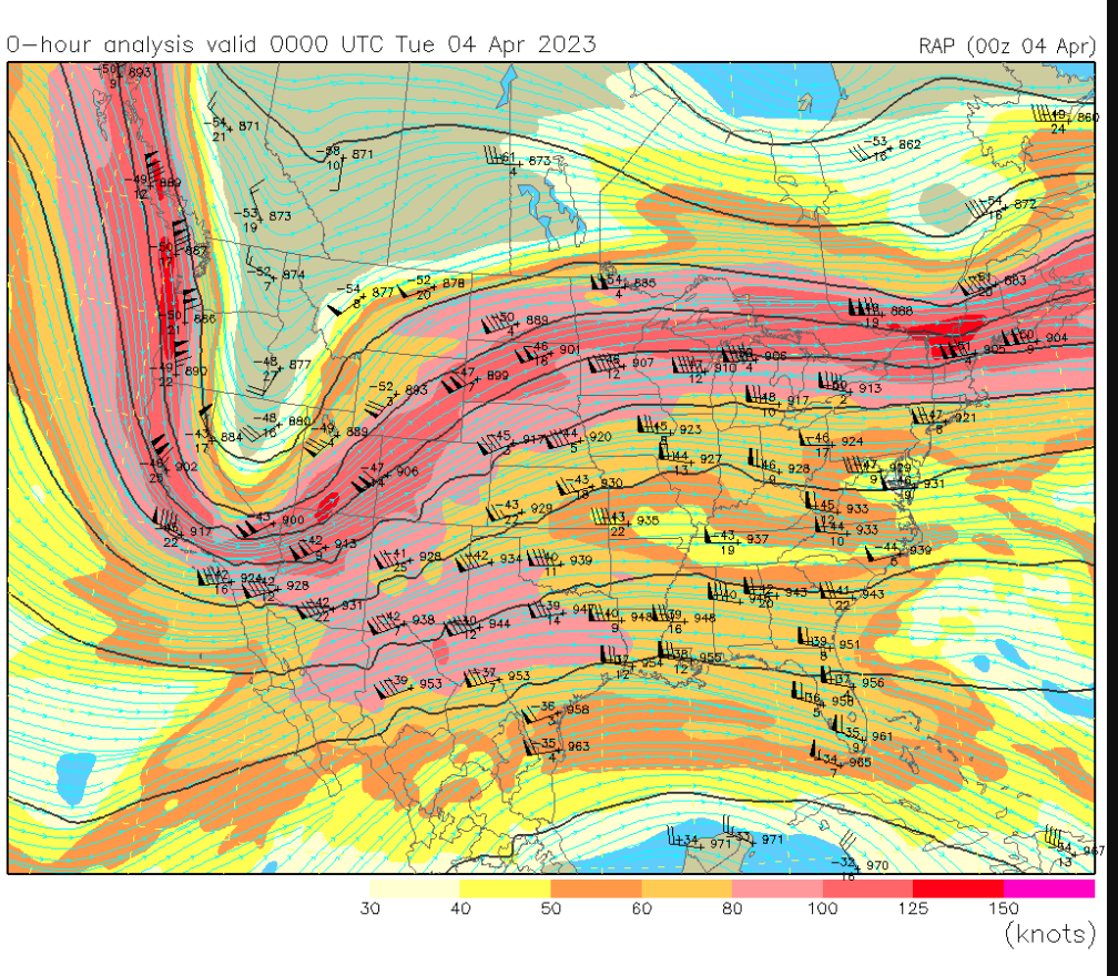
The JET STREAM at 33,000 feet delivering strong north and northwest flow to the region.
Today 7-8 Weather :
Mostly sunny, with wind chill values as low as -4 and gusts as high as 26 mph
Today 7-8 Wind Direction:
NW
Today 8-9 Weather:
Partly sunny. Wind chill values as low as -25. Blustery, with a north northwest wind 15 to 22 mph, with gusts as high as 33 mph
Today 8-9 Wind Direction:
N
Tomorrow 7-8 Weather:
A 30 percent chance of snow. Mostly cloudy
Tomorrow 7-8 Wind Direction:
S
Tomorrow 8-9 Weather:
Partly sunny. A 10 percent chance of snow showers after 11am
Tomorrow 8-9 Wind Direction:
W
Tonight 7-8 Weather:
Mostly cloudy
Tonight 7-8 Wind Direction:
NW
Tonight 8-9 Weather:
Mostly cloudy. Wind chill values as low as -14
Tonight 8-9 Wind Direction:
N
26
2
29
16
146
0
0
10.5
8.5
18.5
12.5
204.8
0.6
0
Grey Butte Temp Max:
15.5
Grey Butte Temp Avg:
10.5
Grey Butte Wind Max:
28.5
Grey Butte Wind Gust Max:
73.6
Castle Lake Snow Depth:
179
Mount Eddy Temp Cur:
14.5
Mount Eddy Wind Gust Max:
8.06
Mount Eddy Snow Depth:
164
Ash Creek Bowl Temp Cur:
12.5
Ash Creek Bowl Temp Min:
10
Ash Creek Bowl Temp Max:
23
Ash Creek Bowl Temp Avg:
14
Ash Creek Bowl Snow New:
0
Ash Creek Ridge Temp Cur:
8
Ash Creek Ridge Temp Min:
6
Ash Creek Ridge Temp Max:
15.5
Ash Creek Ridge Temp Avg:
10
Ash Creek Ridge Wind Cur:
0
Ash Creek Ridge Wind Max:
0
Ash Creek Ridge Wind Gust Max:
0
Mt. Shasta City Temp Cur:
29
Mt. Shasta City Temp Min:
28
Mt. Shasta City Temp Max:
40
Mt. Shasta City Temp Avg:
32.5
Mt. Shasta City Wind Cur:
9
Mt. Shasta City Wind Min:
0
Mt. Shasta City Wind Max:
9
Mt. Shasta City Wind Avg:
4
Grey Butte Wind Avg:
18.5
Ash Creek Ridge Wind Min:
0
Ash Creek Ridge Wind Avg:
0
Sand Flat Snow Settlement:
1
Ski Bowl Snow Settlement:
0
Castle Lake Snow Settlement:
1.7
Mount Eddy Snow Settlement:
1.9
Ash Creek Bowl Snow Settlement:
0
Measured Precipitation Oct:
39.81
Normal Precipitation Oct:
30.82
Percent Precipitation Oct:
129
Measured Precipitation MTD:
0.09
Normal Precipitation MTD:
0.28
Percent Precipitation MTD:
32
Measured Precipitation YTD:
30.68
Normal Precipitation YTD:
18.58
Percent Precipitation YTD:
165
Tomorrow Wind Max 7-9:
15
Tonight Wind Max 9-11:
15
Tomorrow Wind Max 9-11:
15
Tomorrow Wind Min 9-11:
5
Tonight Snow Max 7-9:
0.50
Tomorrow Snow Max 7-9:
0.00
Tonight Snow Min 7-9:
0.00
Tomorrow Snow Min 7-9:
0.00
Today Snow Max 9-11:
0.00
Tonight Snow Max 9-11:
0.00
Tomorrow Snow Max 9-11:
0.00
Today Snow Min 9-11:
0.00
Tonight Snow Min 9-11:
0.00
Tomorrow Snow Min 9-11:
0.00
Weather Station Discussion:
The table below summarizes data reported from all of our weather stations over the last 24 hours.
Seasonal Stats Discussion:
The wet season is October 1 through May 1. The table below summarizes recorded vs. normal precipitation amounts for the City of Mount Shasta.
Overall Danger Rating:
Considerable


