

You are here
Avalanche Forecast for 2019-03-28 05:21
- EXPIRED ON March 29, 2019 @ 5:21 amPublished on March 28, 2019 @ 5:21 am
- Issued by Nick Meyers - Shasta-Trinity National Forest
Bottom Line
Previous and continued wind loading will keep the wind slab problem in play today. Near and above treeline terrain impacted by southwesterly wind is your primary concern. Avalanche starting zones just below ridgelines, near the tops of bowls or steep convex rollovers should be approached with caution. Pay attention to wind blowing snow and what direction it's headed. Natural avalanches are unlikely, human triggered avalanches are possible.


Avalanche Problem 1: Wind Slab
-
Character ?

-
Aspect/Elevation ?
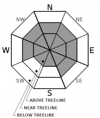
-
Likelihood ?CertainVery LikelyLikelyPossible
 Unlikely
 -
Size ?HistoricVery LargeLargeSmall

Watch for wind slabs near and above treeline today. Uncertainty exists above treeline due to recent poor visibility and lack of observations along wind exposed ridges. Several crust layers exist in the snowpack, with soft snow sandwiched in between. Look for active blowing snow, recent wind drifts and cornices. These are signs of wind loading.
Forecast Discussion
We know the Mount Shasta climbing season is right around the corner...but for now winter lives on. We get a two day window of decent weather this weekend prior to more rain, snow and wind next week. Early season climbers should be prepared for avalanche conditions and carry a beacon, shovel and probe...and know how to use them. Post-holing (i.e. sinking up to your calf, knee or thigh in soft snow) can also be a real problem. High wind can create dangerous wind chill and whiteout conditions on the mountain. Every year, climbers become lost, injured and/or die on Mount Shasta. The bottom line: BE PREPARED, check the forecast and make sound decisions."Sometimes the mountains are saying get out of here...and sometimes the mountains are saying come on in, it's time to party." -Jeremy Jones
Recent Observations
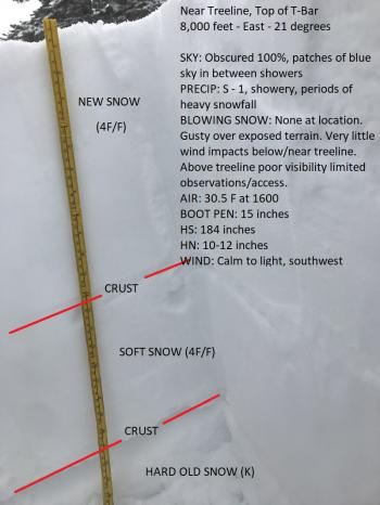
Snow started to fall at 2300 on the evening of the 26th and did not stop for 14 hours. New snow totals of 10-12 inches was observed at Bunny Flat and in the Old Ski Bowl. On the west side, Castle Lake and Eddies, about half that was recorded by weather stations. Snowmobile grooming operations out on the east side, Medicine Lake area, observed upwards of 2 feet of new snow! These snow totals typified the storm...very localized, showery conditions with periods of heavy snow, isolated to specific areas. One minute hosted partial clearing with blue sky donut holes, the next a complete whiteout and snowing. A late afternoon tour on the south side of the big hill did not show any glaring instabilities, however visibility was tough. While Gray Butte recorded 14 mi/hr average speeds with gusts to 37 mi/hr ranging from S/SW to W/NW, on the snow observations in the Old SKi Bowl revealed little in wind effect. Comparing other public observations, winds seemed variable and isolated. Uncertainty exists higher on the mountain where conditions could be different in terrain exposed to wind. Snowpit tests were inconclusive below and near treeline. Small tests slopes were unreactive. Snow surfaces were smooth and soft with poor slab properties. An unconfirmed wind slab avalanche near the top of Sun Bowl was thought to have been observed (poor visibility).

Weather and Current Conditions
Weather Summary
A winter weather advisory is in effect through 10am Thursday around the McCloud area above 4,000 feet. Low pressure off the coast of California will spin southwest flow aloft, and host cool and showery weather today. Snow levels should reside near 4,500 feet, with an accompanied .5 inches of water. We should see several inches of new snow that will arrive in waves. Over exposed terrain, moderate southwesterly wind will be in place. In general, expect a gradual tapering of precipitation and wind over the next 24-48 hours. The weekend appears to be mostly clear. Next week... warm, sunny, spring-like weather will evade us. More wet weather is on the way.
24 Hour Weather Station Data @ 2:00 AM
| Weather Station | Temp (°F) | Wind (mi/hr) | Snow (in) | Comments | ||||||||
|---|---|---|---|---|---|---|---|---|---|---|---|---|
| Cur | Min | Max | Avg | Avg | Max Gust | Dir | Depth | New | Water Equivalent | Settlement | ||
| Mt. Shasta City (3540 ft) | 36 | 32 | 47 | 35.5 | 1 | N | ||||||
| Sand Flat (6750 ft) | 26 | 24 | 38 | 30 | 146 | 5 | n/a | 1 | ||||
| Ski Bowl (7600 ft) | 21.5 | 21.5 | 30.5 | 25.5 | 184 | 11 | 0.88 | 2 | ||||
| Gray Butte (8000 ft) | 20.5 | 20.5 | 26.5 | 24 | 14 | 37 | SW | |||||
| Castle Lake (5870 ft) | 34 | 27 | 41.5 | 33 | 149 | 6 | 1 | |||||
| Mount Eddy (6509 ft) | 24.5 | 22 | 33.5 | 28 | 2 | 17 | S | 147 | 5 | 1 | ||
| Ash Creek Bowl (7250 ft) | ||||||||||||
| Ash Creek Ridge (7895 ft) |
Two Day Mountain Weather Forecast
Produced in partnership with the Medford NWS
| For 7000 ft to 9000 ft | |||
|---|---|---|---|
|
Thursday (4 a.m. to 10 p.m.) |
Thursday Night (10 p.m. to 4 a.m.) |
Friday (4 a.m. to 10 p.m.) |
|
| Weather | Snow showers all day, tapering off into the afternoon. Breezy. Snow levels near 3,600 feet. | Cloudy. Rain and snow showers. Fading precipitation. Snow level near 3,900 feet. | Mostly cloudy, slight chance of snow showers in the morning. Gradually clearing, partly cloudy. Snow levels near 3,900 feet. |
| Temperature (°F) | 32 | 25 | 38 |
| Wind (mi/hr) | Southwest 10-15 | Southwest 5-10 | Southwest 0-5 |
| Precipitation SWE / Snowfall (in) | / 3-6 | / .5-2 | / < .5 |
| For 9000 ft to 11000 ft | |||
| Thursday | Thursday Night | Friday | |
| Weather | Snow showers. Windy. | Snow showers. Breezy. | Slight chance of lingering snow showers. Clearing, partly sunny. |
| Temperature (°F) | 12 | 10 | 13 |
| Wind (mi/hr) | Southwest 20-30 | Southwest 4-8 | West/Southwest 5-15 |
| Precipitation SWE / Snowfall (in) | / 4-8 | / 1-3 | / < .5 |
Season Precipitation for Mount Shasta City
| Period | Measured (in) | Normal (in) | Percent of Normal (%) |
|---|---|---|---|
| From Oct 1, 2025 (the wet season) | 34.48 | 34.93 | 99 |
| Month to Date (since Jun 1, 2026) | 4.95 | 5.43 | 91 |
| Year to Date (since Jan 1, 2026) | 26.07 | 19.72 | 132 |

